Prevalje - Sveta Barbara in Zagrad (gentle path)
Starting point: Prevalje (409 m)
| Latitude/Longitude: | 46,54410°N 14,93190°E |
| |
Route name: gentle path
Walking time: 6 min
Difficulty: easy unmarked way
Elevation gain: 26 m
Elevation difference along the route: 26 m
Map: Koroška 1:50.000
Recommended equipment (summer):
Recommended equipment (winter):
Views: 307
 | 1 person like this post |
Access to starting point:
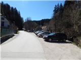
From Mežica, border crossing Holmec or Ravne na Koroškem, we drive to Prevalje, where between the stores Hofer and Eurospin, at the inn Gostilna Brančurnik, we turn onto a side road which continues towards the south. At the spot where we leave the main road there are hiking signposts for Uršlja gora, and we park only a little further on a larger macadam parking lot.
Route description:
From the parking lot, we return to the main road, and then we continue on the sidewalk in the direction of Mežica. The path leads us past the bus stop, and then we get to a crossroad, where an asphalt road branches off to the left towards the cemetery. Before we cross the mentioned road, we go left on a wide and fenced footpath which starts ascending on the slope. After a few steps, below the chapel of St. Rozalija, the path splits, and we continue straight on a still wide path (right steep path). The path ahead slowly turns to the right, and higher up the south path joins from the left.
We continue straight and after a few steps of additional walking, we get to the church of St. Barbara.
Description and pictures refer to the condition in the year 2018 (April).
Photos:
 1
1 2
2 3
3 4
4 5
5 6
6 7
7 8
8 9
9 10
10 11
11 12
12 13
13
Discussion about the trip Prevalje - Sveta Barbara in Zagrad (gentle path)
To post a comment you must log in:
If you do not yet have a username, you must first
register.