Starting point: Pri Rosu (685 m)
| Latitude/Longitude: | 46,44900°N 13,92430°E |
| |
Walking time: 15 min
Difficulty: easy marked way
Elevation gain: 30 m
Elevation difference along the route: 33 m
Map: TNP 1:50.000
Recommended equipment (summer):
Recommended equipment (winter): crampons
Views: 6.782
 | 2 people like this post |
Access to starting point:
We leave the Gorenjska motorway at the Jesenice - west exit, and then continue driving in the direction of Kranjska Gora. Just a little before the village of Dovje, the road which leads towards Mojstrana and the valleys of Krma, Kot and Vrata branches off to the left. At the crossroads we follow the mentioned road in the direction of the Vrata valley, and drive along it to the Pri Rosu parking lot.
Route description:
At the end of the parking lot there are numerous signs, and the path immediately splits into two parts. We choose the left path (straight to Koča pri Peričniku - by road), which crosses the Triglavska Bistrica river over a bridge and then on the other side we continue left (right path of Triglavske Bistrice towards the Peričnik waterfall and Aljažev dom v Vratih). We continue along the Triglavska Bistrica without major changes in altitude. We "overlook" the first turn-off to the right, at the second we turn right. From the junction onwards, the path begins to ascend transversely through a mostly coniferous forest and in a few minutes passes from the slope into a smaller valley through which a stream runs. Here the path flattens and continues along the mentioned pleasant stream. Several tens of meters further, the path from Mojstrana also joins us (in the path description path Dovje - Kreda Lake), and we continue right here and after a few steps arrive at the mentioned lake.

Photos:
 1
1 2
2 3
3 4
4 5
5 6
6 7
7 8
8 9
9 10
10 11
11 12
12 13
13 14
14 15
15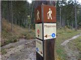 16
16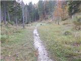 17
17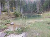 18
18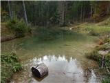 19
19
Discussion about the trip Pri Rosu - Jezero Kreda
|
| ločanka13. 03. 2016 |
Extremely attractive destination, extraordinary nature. But it's true that pictures don't convey enough here. The only thing that bothered me in this environment was the large number of whitefish in the lake.
|
|
|
|
| Gdu bo meni reku svinja14. 03. 2016 |
Are there possibly two Kredas in these parts?
Last year I swam in a turbid turquoise pond in the Radovna valley, which connects Bled and Mojstrana, roughly in the middle between them, and practically behind the road. There were quite a few swimmers who said it's called Kreda. Unlike this lake, that one is on the plain and among meadows.
|
|
|
|
| Lunatic14. 03. 2016 |
There are two, you can swim here without crowds... except snakes 
|
|
|
|
| Lunatic14. 03. 2016 |
There are two, you can swim here without crowds... except snakes
|
|
|
|
| potka14. 03. 2016 |
There's also that little lake on the plain among the meadows And people usually swim in it, or we have swum there too And people usually swim in it, or we have swum there too
|
|
|
|
| Anamarija13616. 02. 2020 |
We were there today. We left the car at Ros and then headed to the lake over the bridge. After the end of the bridge we turned left, there was no sign at first, only after a few meters it is marked on yellow signs to Jezero Kreda. The trail is nice, climbs a bit, then levels out. Part of the trail also runs past the stream and then we spot the lake. Benches are placed by the lake, a small pier. The lake was frozen but with good visibility like looking through glass. Extremely beautiful nature, a real little gem hidden in the forest.
|
|
|
To post a comment you must log in:
If you do not yet have a username, you must first
register.