Prvine - Črni vrh (Čemšeniška planina)
Starting point: Prvine (870 m)
| Latitude/Longitude: | 46,18670°N 14,93950°E |
| |
Walking time: 1 h
Difficulty: easy marked way
Elevation gain: 334 m
Elevation difference along the route: 334 m
Map: Posavsko hribovje - zahodni del 1:50.000
Recommended equipment (summer):
Recommended equipment (winter):
Views: 48.932
 | 2 people like this post |
Access to starting point:
From the highway Ljubljana - Celje we go to the exit Trojane. Further, we continue in the direction of Zagorje and the road then runs through the tunnel V Zideh after which we will get to the spot, where the road towards the village Šentgotard branches off to the left upwards. At the end of the village Šentgotard we come to the crossroad, where we continue left in the direction of Prvine (right Čemšenik). A little further, we come to the next crossroad, where we continue right again in the direction of Prvine (left Zaplanina). The road then soon brings us to the next crossroad, where we continue left in the direction of Prvine (right Čemšenik). We follow this road, which then runs past the hunting lodge, to the parking lot near the ski center on Prvine.
From Zagorje we drive through Kisovec and Izlake towards Trojane, but only to the spot where the road towards Šentgotard branches off to the right. Further, follow the above description.
Route description:
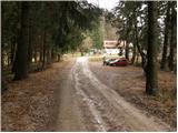
From the parking lot, we continue on the road along which we parked. The road then bypasses the house on the left side, which we see in front of us, and only a little further crosses the ski slope. Right at the spot where the road crosses the ski slope, we leave it and go right upward on a cart track which also crosses the ski slope. The path then goes into the forest and gently ascends towards the east. The path, which only occasionally ascends a little steeper, crosses some paths and cart tracks. But because the path is well marked, there are no problems with orientation. A little further, the path from Zagorje, Izlake and Čemšenik joins from the right. The path ahead runs along the edge of the steep hayfields of Čemšeniška planina from which beautiful views open up mainly towards Kum. A few minutes of walking along the edge of steep hayfields follow, then we come to the spot where the cargo cableway crosses the mountain path. Here we carefully cross the cableway, taking care not to hit the steel cable with our head. On the other side of the cableway, we already notice the mountain hut, which we reach in a few steps.
From the mountain hut, we continue forward towards the east on the path which at first runs along the edge of steep hayfields then goes into the forest. The path through the forest then only slowly ascends and after 15 minutes of walking from the mountain hut brings us to the logbook box, which is located only a few steps below the summit.

Photos:
 1
1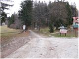 2
2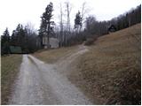 3
3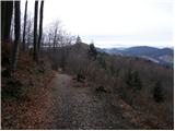 4
4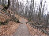 5
5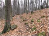 6
6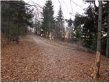 7
7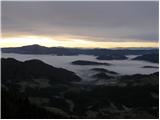 8
8 9
9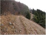 10
10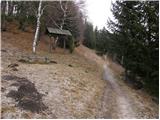 11
11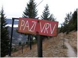 12
12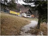 13
13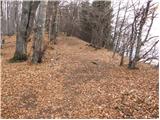 14
14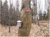 15
15 16
16
Discussion about the trip Prvine - Črni vrh (Čemšeniška planina)
|
| Gost7. 12. 2007 |
The man behind the bar at the hut on Čemšeniška planina is "freh", insane. We know that all hikers in the hut are equal, even those who bring their own snack. Isn't there a more friendly person!!!!! Maria
|
|
|
|
| Gost10. 12. 2007 |
and the swings at the hut are death traps. Š.
|
|
|
|
| Gost18. 12. 2007 |
I was always satisfied with the service in the hut. The path is also nice and short, so it's suitable even for those with less fitness.
Greetings Anja
|
|
|
|
| Gost19. 12. 2007 |
Of course, when you ate their food. We bring our own because food in huts is really very, very expensive. For our 5-member family, 30 euros just for stew without bread is a big bite. It is expensive, so we were probably in the caretaker's way. LP Maria
|
|
|
|
| nadjau7. 04. 2008 |
Beautiful spring excursion. Not at all strenuous walk through the forest, enlivened by nearby birdsong and scenic terraces on hayfields right below the hut.
Comments regarding the "mood" of the caretaker are quite appropriate. With a bit of good will, many problems would be solved. But "panic" is present already with modestly occupied all six tables in the hut (2 hikers per table)!????
Prices. Disaster. Turkish coffee - 2 EUR, without receipt of course!!!
All problems are solvable, right?? We jumped in to help with serving and with good will and mountaineering optimism infected the other waiting ones......The accordion player, due to frozen hands, swapped the windy concert stage in front of the hut and moved indoors......we even danced.
May your excursion be as nice as ours was, on Sunday, 6. 4. 2008.
Nadka, Kamnik
|
|
|
|
| klavdipo11. 05. 2008 |
A nice May day lured me to Čemšeniška planina. I must admit that the service in the hut was really very friendly, even though I didn't eat their food. Special praise goes to the slightly older lady who served at the bar!
Otherwise, the path is really not steep and I recommend it also to those with a bit less fitness.
|
|
|
|
| nod328. 01. 2010 |
I'm interested if the hut is open also in winter time?
|
|
|
|
| dm8. 01. 2010 |
Open on Saturdays, Sundays and holidays.
LP
|
|
|
|
| čemšeničan11. 01. 2010 |
Yes, on Saturday when it was snowing there were quite a few of us in the hut, Sunday was sunny, and there were even more visitors than on Saturday, which is proof of the hut keeper Helena, that she also takes care of us, when I met her on Sunday carrying such a big backpack from Prvine to the mountain pasture. Thank you Helena, may your health serve you for a long time.
|
|
|
|
| Jany29. 03. 2010 |
On Čemšeniška the first "čemaž" has already appeared. Information for those who like to pick it, make pesto from it, various spreads and cook soups.
Lp
|
|
|
|
| ZOJA20. 11. 2010 |
Tomorrow we'd head to Črni vrh. What are the conditions? Is the hut open? Tomorrow should hold without rain...
Best regards!
|
|
|
|
| Valuk23. 12. 2010 |
With the group we set off today to Čemšeniška planina from Prvine direction.
According to PZS info the hut should have been open. But unfortunately it wasn't and to our great disappointment we had to push on hungry and freezing.
Obviously the info on open huts on PZS pages is outdated!
|
|
|
|
| mbohinc224. 12. 2010 |
Hey! Čemšeniška planina is open only on weekends-Friday, Saturday and Sunday!
|
|
|
|
| starakapa26. 02. 2011 |
Yesterday I was at Čemšeniška planina and Črni vrh. The hut is open Fridays, Saturdays and Sundays. There were quite a few people. Through the forest it's snowy but not icy. From the saddle to the hut it's muddy-wet. First calves have already been born along the path. NO STAMP at the top of Črni vrh.
Different caretakers in the hut than last year. They are friendly and communicative-young. Food as always good and tasty, and prices not high
2x schnapps and 2x tea costs 4 euros. Weather was sunny and a bit windy. View along the path to nearby peaks was fantastic.
|
|
|
|
| starakapa26. 02. 2011 |
Yesterday I was at Čemšeniška planina and Črni vrh. The hut is open on Fridays, Saturdays, and Sundays. There were quite a few people. The path through the forest is snowy but not icy. From the saddle to the hut it is muddy-slippery. Along the path the first calves have already been born. At the top of Črni vrh there is NO ŽIGA.
In the hut there are different caretakers than last year. They are friendly and communicative-young. Food as always good and tasty, and prices are not high.
2 x schnapps and 2x tea cost 4 euros. The weather was sunny and somewhat windy. The view along the path to nearby peaks was superb.
|
|
|
|
| VanSims4. 04. 2011 |
@nadjau
those who inquire beforehand about prices (price list, menu or don't spare the tongue) know how to get quite significant discounts in taverns and mountain posts. The prices in price lists and menus are already written with that discount. Specifically for the Turkish coffee you mention, the discount on Čemšeniška planina is as much as 50%. 
|
|
|
|
| nadjau4. 04. 2011 |
Oops. It must be true: "Who spares the tongue, starves for bread". Apparently the staff has changed in these three years too, right?
|
|
|
|
| VanSims6. 04. 2011 |
@nadjau
Unfortunately, I don't know if anything has changed because I was there for the first time this weekend.
|
|
|
|
| dušan6. 04. 2011 |
Yes, the caretakers changed before winter.
lpd
|
|
|
|
| CarpeDiem2477. 01. 2013 |
Yesterday my colleague and I were at Koča on Čemšeniška planina. There is no talk of any arrogant waitresses, prices are also reasonable; 2 Radlers and 2 Medicos, total 9€. A cool young lady about 25 years old served us. 
|
|
|
|
| jvali7. 10. 2017 |
Today with school kids (mountaineering club) on Čemšeniška planina and then to the summit, where they want to build a lookout tower. Weather excellent, great views, just above the starting point Grintovec was visible in all its beauty. Food in the hut really tasty, all praise to the kitchen! Not to mention the strudel... Friendly staff, in short, a beautiful autumn excursion. Val.
|
|
|
|
| grega_p23. 10. 2019 |
Beautiful autumn day up there.
Fantastic views, especially at the bench a bit below the hut. On the summit section trees are already leafless, surprisingly quick given temperatures. Probably dry spell and wind taking effect.
At the hut they're digging a hole for cistern so it's quite churned up. Same below at start where they're felling and hauling timber.
Also note if you want circular tour via Črni vrh and descend towards Vransko then at one bend turn onto unmarked path crossing northern slopes of Čemšeniška planina it's good if you find it :-) I didn't so descended to lower road to Blodnik then half hour more up to start at hotel.
lp Grega
|
|
|
|
| plaNinaPirsMajcen21. 02. 2025 16:36:11 |
https://youtu.be/1SW1izslpOY?si=tVdTS2YEBUqPCioM
I recorded the video 3 days ago. I recommend the hike, nice winter tour ❄️
The road to Prvine was icy in the gravel section, but properly gritted and I had no problems. Past the frolicking children on the ski slope, I set off on an enjoyable, easy, this time solitary path. I didn't meet anyone, except one gentleman overtook me while I was filming, a little below the summit.
The markings are new. For someone who hasn't been to Čemšeniška yet, I'd mention that the logbook box and stamp are below the summit, on one tree where the path continues in another direction. I filmed that in the video. The actual summit is behind, behind the radio amateur hut, marked with a larger cairn.
Best regards, Nina
|
|
|
To post a comment you must log in:
If you do not yet have a username, you must first
register.