Ravenska Kočna - Češka koča na Spodnjih Ravneh (Ferata)
Starting point: Ravenska Kočna (1000 m)
| Latitude/Longitude: | 46,38474°N 14,53644°E |
| |
Route name: Ferata
Walking time: 2 h
Difficulty: extremely difficult marked way
Via ferrata: E
Elevation gain: 542 m
Elevation difference along the route: 542 m
Map: Kamniško Savinjske Alpe 1:50.000
Recommended equipment (summer): helmet, self belay set
Recommended equipment (winter): helmet, self belay set, ice axe, crampons
Views: 97.414
 | 6 people like this post |
Access to starting point:
From the Ljubljana - Jesenice highway, we take the exit Kranj - east and follow the road ahead in the direction of Jezersko. At Zgornje Jezersko, just a little after the gas station, we will notice a road which branches off to the right from the main road (direction Planšarsko jezero). The road then leads us past the mentioned lake and behind it for a short time steeply ascends. Higher, the road flattens and at the beginning of a large meadow loses its asphalt surface. We then follow the macadam road to a marked larger parking lot.
Route description:
From the parking lot, we continue on a macadam road following the signs »Češka koča, Ledine« and after approximately 15 minutes of walking, we come to a cargo cableway. At the cargo cableway where there is a junction, we continue following the signs Kranjska koča na Ledinah (Skozi žrelo/Slovenska pot) and Češka koča (umik žrela). At first for a short time, we walk through the forest and then the path brings us to terrain which is partly covered with dwarf pines. The path here starts to ascend a little steeper and then brings us to a junction.
We turn right onto the scree where a sign on the rock »Ferata Češka koča« points us. After a short ascent on the scree, we come to the entrance of the climbing path. At the entrance of the climbing path, an easier path also branches off to the left, which bypasses the initial most difficult part of the climbing path. This path is marked with a sign »umik«.
At the beginning, the climbing path ascends very steeply along the steel cable (difficulty C/D) and because there are few footholds, considerable arm strength is needed. A short less demanding traverse follows on a slope covered with grass and dwarf pines (A/B). The path then becomes more demanding again and ascends diagonally up the steep wall (C/D). In the wall, the path turns left upwards and brings us through a short but still quite demanding overhang (E) to somewhat less demanding terrain. Here we ascend along the steel cable on a slope partly covered with grass and dwarf pines (B/C). The path then brings us to easier terrain where the first part of the climbing path ends.
For some time, we then ascend on an undemanding slope through dwarf pines, then we come again to steel cables where the second part of the secured path begins. Here, the path that bypasses the initial most difficult part also joins from the left. For some time, we then ascend along the steel cable on a not overly demanding slope (A/B), then the path turns left and a short vertical ascent follows (D). Continuing, we steeply ascend along the steel cable for quite some time (C and C/D). Such a path then brings us to the logbook box where for a short time the path becomes a shade less demanding (B/C). The path then ascends steeply once more (C/D), after which the steepness begins to ease. The steel cables then end and soon we join the path »umik Žrela«. Here we continue right and to the hut, which we already see ahead, it is only a few minutes' walk.
The described path is extremely demanding and is suitable only for experienced mountaineers with sufficient arm strength. Use of a helmet and self-belay set is mandatory. Use of climbing gloves is also highly recommended.

Along the route: Tovorna žičnica (1080m)
Photos:
 1
1 2
2 3
3 4
4 5
5 6
6 7
7 8
8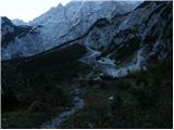 9
9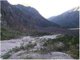 10
10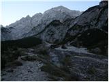 11
11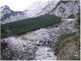 12
12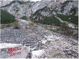 13
13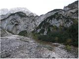 14
14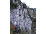 15
15 16
16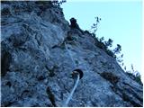 17
17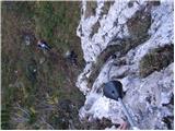 18
18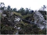 19
19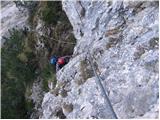 20
20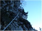 21
21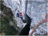 22
22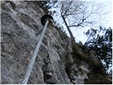 23
23 24
24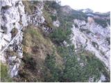 25
25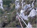 26
26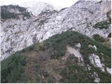 27
27 28
28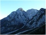 29
29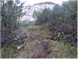 30
30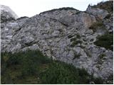 31
31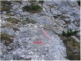 32
32 33
33 34
34 35
35 36
36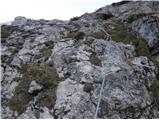 37
37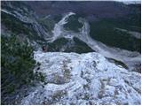 38
38 39
39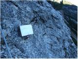 40
40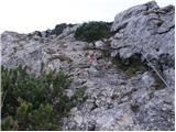 41
41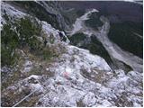 42
42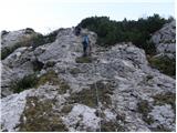 43
43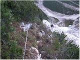 44
44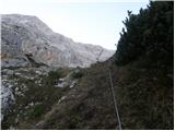 45
45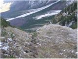 46
46 47
47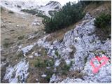 48
48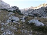 49
49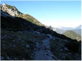 50
50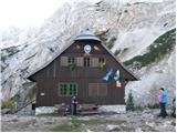 51
51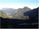 52
52
Discussion about the trip Ravenska Kočna - Češka koča na Spodnjih Ravneh (Ferata)
Show older messages
|
| Matic2523. 10. 2014 |
It looks very difficult. The E overhang is probably the hardest.
|
|
|
|
| jelka10024. 10. 2014 |
The start is immediately vertical then a bit of rest if I can say so, the problem is only that there is a lot of grass and small stones so very slippery the overhang is so-so if you have long legs no panic you pull yourself over with short legs it's oh boy a bit of a problem then strong arms save you otherwise the via ferrata is very nice and varied WORTH TRYING
|
|
|
|
| Matic2525. 10. 2014 |
We'll try it. I'll just wait a bit for this rush to calm down.
|
|
|
|
| subaru25. 10. 2014 |
In the coming week we plan to visit this new via ferrata, and I'm wondering if it's dry - without snow?
|
|
|
|
| Viper25. 10. 2014 |
There is no snow on the rocks. In between on the grass there is a little snow, but it causes no problems. The wall was quite wet today and there's quite a bit of mud so it slips.
|
|
|
|
| ms_primoz30. 10. 2014 |
Conditions are completely wintery and the mentioned path is 2 degrees more difficult than in summer, for example. Mainly because of ice... today a rescue operation took place on the mentioned path because two got stuck, many this week reached the wall and then turned back to the valley. At Češka koča there is 20 cm of frozen snow, all other paths from the hut onwards are completely wintery.
|
|
|
|
| urbancek2. 11. 2014 |
Interesting via ferrata, "spiced up" with some more difficult sections. Experience on such paths is necessary, and one should approach it with proper equipment and respect. There is still a lot of loose earth in the wall and consequently in these humid days the shoes slip a lot, so extra caution won't hurt. Good luck!
|
|
|
|
| Tanja723. 11. 2014 |
I would like to thank Mr. Franci once again for helping me over the overhang E  . I couldn't have done it alone! And also thanks to the guys who accompanied us in the second part! To the less experienced, I recommend bypassing the first part and starting the ascent in the second somewhat demanding part. Good luck! . I couldn't have done it alone! And also thanks to the guys who accompanied us in the second part! To the less experienced, I recommend bypassing the first part and starting the ascent in the second somewhat demanding part. Good luck!
|
|
|
|
| Matic253. 11. 2014 |
It wouldn't leave me alone and I went (successfully) to climb it. The ferrata didn't give me trouble except slightly overhanging E. The ferrata is definitely not easy. Currently 223 of us have signed the book. Good luck!
|
|
|
|
| Branee4. 11. 2014 |
Congratulations to all who are in such good shape that they can lift themselves up with their arms even once.
|
|
|
|
| Sebo135. 11. 2014 |
Last week we went to try it, it's great, but helmet on the head is obligatory because of falling rocks especially in the first part of the wall.
|
|
|
|
| sport-bi24. 06. 2015 |
At the beginning of the week after prolonged rain, we went along this via ferrata. Because there is quite a bit of soil in the initial part, slippery shoes were a problem at the entry. Otherwise an interesting via ferrata. The overhang requires some concentration. From there on it's no longer difficult.
|
|
|
|
| UrbanH2. 08. 2015 |
Yesterday I went climbing this via ferrata with two friends. The beginning is already quite difficult, the most difficulties were on the E difficulty section.
Since I had a lot of trouble, I couldn't climb that part at all. Solidarity and mutual assistance are essential in the mountains. Fortunately, two climbers who went ahead of us on the via ferrata helped us by lowering a rope. Then Mr. Uroš climbed up to me and relieved me of my backpack.
Thanks once again for all the effort and help!
The via ferrata to Češka koča is really extremely demanding and from my own experience I can say it's only for exceptionally fit and experienced hikers.
LP
|
|
|
|
| UROS12. 08. 2015 |
Yes, this via ferrata is in my opinion the second hardest in Slovenia, right after Gonžarjeva peč, which has two E sections. But if I look at this via ferrata to Češka koča as a whole, I'd say it's the hardest in Slo, as it's much, much longer than Gonžarjeva peč.
Yes, no problem UrbanH, this time you needed help, next time I might need it somewhere. Real hikers help each other, right? Just glad it all ended safely .... did you turn back from that half of the via ferrata and go back via the scree??? .... did you turn back from that half of the via ferrata and go back via the scree???
|
|
|
|
| urbancek2. 08. 2015 |
This via ferrata can only be a problem for those who tackle it lacking experience on such routes, with inappropriate or too heavy gear and insufficient physical fitness . .
|
|
|
|
| UrbanH3. 08. 2015 |
UROS1, only my friends ventured into the second part of the via ferrata and successfully climbed it. I went via the scree. At the entrance to the second part of the via ferrata there were quite a few hikers who bypassed the first part, then realized that the second was too difficult for them too. Together we then went in the direction of Slovenska pot towards Kranjska koča na Ledinah, where my friends who climbed the via ferrata arrived later. Descent was via the hunting path.
|
|
|
|
| UROS13. 08. 2015 |
Yes, the second part wasn't as easy as I expected at all, especially the initial part of the second.... just that we all succeeded one way or another...
|
|
|
|
| don kihott19. 08. 2015 |
UROŠ1 in Slovenia we don't have via ferratas rated E yet...The entry wall at Gonžarjeva peč justly has a D/E rating, that overhang in the via ferrata to Češka koča is possibly overrated (misleading!!!) and maximally reaches C/D rating....Gonžarjeva peč is a typical sports via ferrata, the one to Češka koča I would classify among mountain via ferratas like....Cjajnik, Via Italiana...etc...
|
|
|
|
| andrej7819. 08. 2015 |
We have one at Lisco...the last section is E...
|
|
|
|
| don kihott19. 08. 2015 |
This thing at Lisco the last part is rated D/E in all descriptions already in the article in the latest mountaineering bulletin and I hope it's not just misleading and overestimation of the actual difficulty here too!!!
|
|
|
|
| ms_primoz19. 08. 2015 |
and again we're at the ratings.... one says A, another E... it hurts my a**.... someone says Šmarna H. so what then, are you going to investigate and debate if it's true or not? everything is relative, so is the path rating (it depends on the individual and their physical strength, psyche, daily form, moon, sleep, food,...)
|
|
|
|
| don kihott19. 08. 2015 |
Well now at least I know that we don't need ratings anymore and that they are just written for show...
|
|
|
|
| Keko19. 08. 2015 |
Three years ago I climbed a via ferrata that has a pure E rating and I can say that Gonžarjeva peč, Železna kaplja, let alone the via ferrata to Češka koča, cannot even remotely compare to this one. Already on the overhanging ledge rated C we were all hanging on our slings. On the section rated C/D that goes diagonally across a smooth slab, two already bailed who had climbed Železna Kapla and Gonžarjeva peč without problems. They simply couldn't make it. The fact that we needed a solid 4 hours for less than 400 meters of cable says it all.
You can read the report from this via ferrata here: http://www.gore-ljudje.net/objava/81230/
|
|
|
|
| don kihott20. 08. 2015 |
Finally someone who knows what I mean to say......Keko I have to tell you, I was also planning for that Kristall klettersteig but I was informed too late...I've climbed with most of these gentlemen (Mijo, Milan, Tone)..That via ferrata is really ghostly!!! The ladder with negative incline where the E section is looks completely innocent!!!....Good thing those two bailed earlier because bailing at those ladders would only be possible by abseiling and much more demanding...The closest to E rating in our area is that overhang in Železna kaplja if we climb it without using the pegs...best regards
|
|
|
|
| Sujcic20. 08. 2015 |
The mentioned detail in the Kristall klettersteig is probably E/F
|
|
|
|
| Keko20. 08. 2015 |
A few years ago it really had an E/F rating, but later they downgraded it to E. Even the sections with C and D ratings are very demanding and already quite comparable and sometimes even harder than the hardest sections in Gonžarjeva peč or Železna Kaplja. The characteristic of this via ferrata is that a large part is overhanging and requires a lot of stamina, as the arms are extremely strained.
|
|
|
|
| don kihott20. 08. 2015 |
One must simply experience this, only then does one know what one has gotten into and where one's limits are.... Only then do we begin to realize our smallness and insignificance, when a sheer wall stands before us and its difficulty instills fear in us, the appearance over the internet can be very deceptive... That's why the ratings are definitely very important!!!
|
|
|
|
| KUKI7721. 08. 2015 |
The rating is between D and D/E (possibly D+ like 26), definitely not E or C/D. And don't mislead either one or the other.
C/D Peca significantly easier, D/E Železna kaplja harder.
|
|
|
|
| don kihott21. 08. 2015 |
No offense KUKI77, if you're following that C/D from the Walter Mory ferrata on Peca, I half understand (you'll have to climb some real C/D section somewhere abroad) to get a better idea of what C/D looks like... Železna kaplja and the ferrata to Češka koča can't even be compared in terms of difficulty ratings!!!
|
|
|
|
| klemen7323. 08. 2015 |
Today I also did Gonžarjeva peč, which is significantly harder than Češka koča, so I agree with all those who think that Češka koča with "E" is overrated.
Lisca is also harder than Češka koča.
|
|
|
|
| klemen733. 03. 2016 |
Spodnji Plot - Zelenica is considerably more difficult than Gonžarjeva peč.
|
|
|
|
| frajer16. 05. 2016 |
What are the conditions like on the via ferrata or in general from Jezersko to Češka koča?
|
|
|
|
| 75'er17. 05. 2016 |
@klemen73, you say Lisca is harder than Češka koča? Given that I've been to Lisca several times already, apart from the last overhang it doesn't seem very demanding to me (rated D/E).
For Češka they say the overhang is rated E. So you think it's overrated?
|
|
|
|
| zokica18. 05. 2016 |
Vias ferratas are interesting already for how many doctorates you write about them.
I recommend Kaiser F. Josef in Eisenerc.
A, B, C, D and combinations. The first part up to one is often wet. The length factor is also decisive. 800m wall facing SE.
By the way:
the via ferrata to Češko is not for beginners.
|
|
|
|
| don kihott20. 05. 2016 |
Is the one in Eisenerz difficult?
|
|
|
|
| fico8. 06. 2016 |
Lisca is as demanding as you make it yourself, if you don't use pegs and staples, you need some strength in your arms, otherwise except for the last pitch it's no problem even for beginners.
|
|
|
|
| ms_primoz9. 06. 2016 |
fico - I'd really like to see you climbing Lisca without using staples and cables - especially on the first pitch. Yeah, why are there staples, pegs, cables??? so that they are not used? because you're the king eh. applause.
Lisca is substantially easier than Češka, Lisca only has the last 5th part difficult, the rest is classic demanding secured trail (physically speaking).
Češka is physically harder because it's longer... Both most demanding parts are on Češka slightly harder than on Lisca... On Lisca you lean your back or shoulder on the rock "behind you", on Češka not. And Češka has no artificial steps, Lisca does...
To sum up - Češka is harder than Lisca. Just my opinion. And I've been on both more than once
|
|
|
|
| don kihott15. 06. 2016 |
Ficotov is really too much up here...
|
|
|
|
| barbara.hribi22. 06. 2016 |
Hmm, this one needs to be tried... to Lisca via ferrata I go many times (for training as it's close), Via Italiana already done (and more); I see that for some Lisca is harder, for some Češka - anyway according to description Češka is much longer...
|
|
|
|
| barbara.hribi4. 07. 2016 |
I have to kinda agree with the comment by "ms primoz". The via ferrata to Češka koča is definitely harder than to Lisca because it's much longer, but I managed it without any special problems. The first part is really demanding and long, while at Lisca only the last pitch is very demanding. Then from Češka koča over the gully to Kranjska koča and back via the Slovenian route. Nice tour, no doubt (even nicer with my dearest!)
|
|
|
|
| gornica6. 07. 2016 |
Hello, I'm interested if anyone knows how the passage from Češka koča to Kranjska koča through Žrelo is? Thanks.
|
|
|
|
| barbara.hribi6. 07. 2016 |
Gornica, from Češka koča to Kranjska koča through Žrelo we went with mine last Saturday (2.7.) without any special problems. There is still some snow in the basin, but it can be crossed carefully even without crampons. If you're even a little experienced, it will be fine without problems.
|
|
|
|
| gornica7. 07. 2016 |
Barbara.hribi, thanks for the info, and I wish you safe steps.
|
|
|
|
| Lisica20. 07. 2016 |
The lower part of the ferrata seemed quite demanding to me, in places muddy, but it went without problems, E wouldn't have climbed it without extra help, really need a lot of strength in arms and good foot placement. The upper second part I liked much more, nice solid rock. In D need a bit more strength again, everything else seems quite undemanding. To those not sure they can manage I recommend trying the upper part first. In wet or damp weather I would avoid this ferrata, especially the lower part.
|
|
|
|
| fico8. 08. 2016 |
ms primoz; before commenting, read the comment carefully. In the comment I wrote that Lisca is difficult if you don't use pegs and brackets, not that I don't use the cable. If you are really so experienced, try without brackets and pegs, and you'll see it works. We can arrange a joint ascent. Every via ferrata allows each individual to climb it according to their abilities, or not climb it.
|
|
|
|
| don kihott8. 08. 2016 |
On Lisca there is no D/E!!! Without using brackets in the last sector we talk about average D rating...
|
|
|
|
| andrej788. 08. 2016 |
Of course it exists... or according to you the guys from the ferrata team have no idea, who built and rated the path...
|
|
|
|
| Viper8. 08. 2016 |
I'd say that the via ferrata on Lisca can earn the highest grade D, and even that a lighter D.
|
|
|
|
| Viper9. 08. 2016 |
Primoz, in my opinion maximum D for this overhanging gully.
|
|
|
|
| Viper9. 08. 2016 |
I completely agree and everyone can have their own opinion on the ratings, because to some the same section seems easier, to others harder.
|
|
|
|
| John27. 09. 2016 |
In the near (possibly this year) or not so near future (next year) I want to climb this ferrata.
When reading comments and various descriptions, I don't get the right information or can't extract an objective opinion. On one side lots of boasting and bragging, on the other quite some exaggeration about the difficulty and about whatever strength needed in arms and about the (for some) notorious for others completely easy overhang etc.
In short, please for, if possible, as objective and realistic opinions as possible about the difficulty of this ferrata or opinions on whether it's suitable for an adult man in his early middle age, averagely strong, who has already climbed secured paths and is used to "scrambling" on rock .
As I mentioned, I want to climb some (sport) ferrata and somewhere you have to start...
Thanks and best regards and safe steps.
|
|
|
|
| redbull27. 09. 2016 |
Best that you go and then tell us. That will probably be the most objective.
Good luck
|
|
|
|
| dprapr27. 09. 2016 |
If you're able to do pull-ups on a bar and know how to use via ferrata kit, you shouldn't have problems on any E difficulty ferrata.
|
|
|
|
| John27. 09. 2016 |
Redbull #moonwash
Dprapr, tnx. Quite tangible information.
|
|
|
|
| branko.temlin27. 09. 2016 |
John, for all ferratas you need some peasant and not computer hands, for testing your ability there's a ferrata right at the border if you go from Dravograd to Austria - Lavamünd on the right side of the road just before the settlement.
|
|
|
|
| jprim27. 09. 2016 |
I think they rescued two on this ferrata who got stuck dancing.
Regards
|
|
|
|
| gj27. 09. 2016 |
They danced willingly though
|
|
|
|
| jprim27. 09. 2016 |
Yeah, right, you really can't dance on a ferrata, so they probably got stuck climbing.
Regards
|
|
|
|
| don kihott28. 09. 2016 |
John: The via ferrata to Češka koča is overrated, that overhang is max C/D!!! (pure misleading)..dprapr: I disagree with your statement regarding (pull-ups and heavy use of SVK).. I believe that's not enough for fluid climbing of via ferrata grade E!!!
|
|
|
|
| dprapr28. 09. 2016 |
If you have wooden armor on your legs, pull-ups really won't be enough.
|
|
|
|
| ljubitelj gora28. 09. 2016 |
To me, three moves seemed harder, the rest went without trouble. Quite a lot of strength is needed and on those three parts the inexperienced can easily get stuck.
|
|
|
|
| don kihott29. 09. 2016 |
dprapr: the best training for a via ferrata climber is climbing via ferratas (there are also special methods for developing explosive maximum strength needed for extreme vias E, E/F and F difficulty!!!)... But for someone to climb grade E fluidly, progression (grading of difficulty) is of course most important and knowledge of moving in overhanging smooth walls without artificial aids (pegs, bolts..etc) and at least basic sport climbing knowledge..
|
|
|
|
| dprapr29. 09. 2016 |
..."knowledge of moving in overhanging smooth walls without artificial aids"...
Yes, if one masters that, then there really won't be problems in the E difficulty ferrata.
|
|
|
|
| don kihott29. 09. 2016 |
In our country the only real sports via ferratas are Gonžarjeva peč and Spodnji plot on Zelenica (right branch), the rest was all added later following the model of our secured paths (which is most evident at Lisca)...
|
|
|
|
| don kihott29. 09. 2016 |
dprapr:Without artificial aids means without (pegs,pitons,slings,chains...etc) since when talking about via ferratas it is self-evident that we climb along a tensioned steel cable which serves for progression and self-belaying
|
|
|
|
| fico2. 10. 2016 |
Of course, but it's not necessary to use such aids even if they are in the wall. This way you dose the difficulty yourself.
|
|
|
|
| palček plezalček2. 10. 2016 |
@don quixote, it's not so self-evident that on via ferratas we climb along taut wire ropes. A nice example of a ferrata or secured climbing path made in the French style is Grnčišće above Mojstrana. The French style of equipment means that the wire ropes are not taut but loose, and thus at the clip loop where we stop in case of a fall with a self-belay kit much more softly, making it safer; but of course pulling or progressing with the aid of the wire rope is much harder. Anyone interested can learn more on this topic from Mitja Šorn, one of the main creators of the ferrata, who has described it on several websites.
|
|
|
|
| don kihott3. 10. 2016 |
Palček I expected you to tell me something really interesting not something that anyone can read on the net...Rubber cones have the same function (they amortize the fall, prevent breaking of karabiners)Progressing along a loose cable is harder anyway because if you hang on it it can pull you out of the wall and you lose contact with the ground...Otherwise this method is more useful on extreme vias ferratas and especially in verticals in chimneys it seems senseless to me!!!.....
|
|
|
|
| don kihott3. 10. 2016 |
Fico:For example in Železni kapli in the D/E overhang you don't step on the pegs but climb only on friction and thus get the feeling that you climb pure E..(probably that's what you meant to say)
|
|
|
|
| klemen734. 10. 2016 |
@75'er
yes, it's definitely overrated.
Those of us who have climbed all 3 (4) Slovenian E's know what is harder and what is easier:
Češka koča, Lisca, Gonžarjeva and Spodnji plot.
|
|
|
|
| fico4. 10. 2016 |
don quixote: You understood me correctly; even on Lisca you can increase the difficulty if you don't use the peg in the first pitch, it's even harder than the fifth because you have a straight wall here and nowhere to brace, plus the chain is often damp. As for the Czech hut, no problem when dry, but if the wall is wet, hands work harder. In Gonžarjeva peč, the second part was harder for me, soon above the logbook box.
|
|
|
|
| don kihott7. 10. 2016 |
Klemen, in Slovenia you could only climb one E and that via the right branch on Zelenica!!! In Gonžarc it's D/E which is not pure E!!! The rest close to E didn't go in Slovenia!!!
|
|
|
|
| don kihott8. 10. 2016 |
Fallbach is long and at some places you really have to watch your step, 8m high vertical climb rated (E) which at the end traverses right to a scenic ramp is the key part of the via ferrata in Fallbach...In my opinion the section rated E in Fallbach is one of the easier Es!!!
|
|
|
|
| don kihott9. 10. 2016 |
For the fence (right variant E) at least basic sport climbing knowledge is needed and it's quite a serious undertaking in via ferrata terms!!! I haven't climbed it myself yet even though it's been on my plan since the opening
|
|
|
|
| matej12330. 12. 2016 |
Has anyone been there these days, what are the conditions, is there any snow?
|
|
|
|
| J.Grega29. 03. 2017 |
Hello, next week I plan to visit the Czech hut, specifically via the via ferrata. I'm wondering if anyone has been nearby or even on the path, how much snow there is and if most of the cable is snow-free? Thank you very much!
|
|
|
|
| marko hribinet7. 05. 2017 |
Hello. Has anyone climbed the ferrata recently? Doable or still snowy? Thanks for info.
|
|
|
|
| skala1239. 05. 2017 |
no snow on the path, but there is scree... and wet rock (5.5.2017)
|
|
|
|
| Peter.B.15. 05. 2018 |
Hello.
Does anyone know what the conditions on the via ferrata are like?
Peter
|
|
|
|
| grega_p16. 06. 2018 |
Also my opinion on the via ferrata.
Nicely equipped, very demanding via ferrata that requires quite some strength in the arms. Especially if you're short, at least in the initial part. In the lower part it really pumped me and changing carabiners on exposed sections was very, if not already too, adrenaline-fueled.
Since the "path" is sometimes "sprinkled" with soil and the rock can be wet for a few days after rain, I recommend it after a few days of dry weather.
Every eye has its painter, but I would paint it as very difficult, if not exceptionally so, at least in the initial part. Maybe a shade easier than Gonžarjeva, personally harder for me than Železna kapla.
Good luck and be careful.
regards Grega
p.s. Češka koča was just opened yesterday for the season - we were unloading crates of beer from the cargo cableway
|
|
|
|
| don kihott17. 06. 2018 |
You buddy really have no realistic idea!!!... Češka koča max grade C/D, don't know who invented grade E here!!!... Gonžarjeva peč and Železna kapla are both significantly more demanding in all respects!!!!
|
|
|
|
| grega_p17. 06. 2018 |
One thing is the grade in letter form, another is the subjective assessment. You can't ignore it, even if you use so many exclamation marks.
Good luck on regular or "iron" paths.
|
|
|
|
| tango21. 08. 2018 |
Ideal conditions, completely dry rock and no heat. Instead of thinking about difficulty, I rather enjoyed viewing the mighty walls and relaxing. Worth many repetitions. Friendly in the hut, one could say!
|
|
|
|
| klarcy6. 11. 2018 |
The start of the second part gave me huge problems, because I'm too small and couldn't climb over it at all, even though I climbed Liščo and Gonžarjevo peč without problems.
|
|
|
|
| don kihott12. 11. 2018 |
Klarcy, since you climbed Gonžar then I don't understand how you could have problems on Češka???
|
|
|
|
| planina7127. 07. 2019 |
On Thursday, July 25, I lost my Ray-Ban sunglasses at the exit from the via ferrata. If anyone found them, I would be very grateful if you let me know on the number zero six four one seven six two.
Thank you very much.
|
|
|
|
| dpavli14. 08. 2019 |
Every group experiences some part and that's why the differences, don't argue, for experienced it's barely C, but for beginners E++++. Btw. Češka koča, CATASTROPHE, 30 euros overnight, hostess extra unfriendly, never again there under any circumstances
|
|
|
|
| pohodnik304. 10. 2019 |
Dear visitors (ferratists), for a long time I have been reading the forum, which is helpful to all of us with valuable information about the condition on various paths where we all meet more or less frequently. I don't like to get involved in that part of the conversation where instead of constructive debate and appropriately substantiated criticism, when someone writes nonsense, they rather criticize those who sincerely ask for advice and help in their ignorance and even mislead them with their "knowledge". Unfortunately, this does not serve the purpose of this valuable and free tool for users, which was created by Rok and Tadej Lukan, to whom I can only sincerely congratulate after reading that over 2500 peaks and as many as 7000 paths are described on these pages, 90% of which were contributed by the authors of this site themselves. At this point, I would like to encourage everyone to write advice responsibly, as these pages are visited by an average of 400,000 people monthly, over a million in summer, and we need to be aware that our advice influences the decisions of other readers. Source: https://siol.net/sportal/naj-planinska-koca/brata-sta-zasnovala-spletno-stran-ki-vsakodnevno-resuje-ljubitelje-slovenskih-gora-505574
Therefore, let me be allowed a slightly longer contribution (hopefully for reflection), where I would like to explain a few more things about commentators, without highlighting any particular one, as each in their own way (although sometimes inappropriate) tries to help other hikers, and at the end I would also touch on the ratings regarding the ferrata to Češka koča.
My wife and I like to go to the mountains and when we run out of adrenaline, we also happily go to the world of ferratas. Since these remote places pleasantly force us to make new contacts, the topic of conversation often turns to the mentioned online forum, which is helpful to all of us. Unfortunately, we notice that one point has become common to the vast majority of ferratists. Everyone expresses quite a bit of dissatisfaction with certain individuals who have a lot "to say and criticize ferratas and other users". At this point, let me highlight user "primoza" as an example of a quality conversationalist, who at least in my and my wife's conviction represents a good example of an individual whose advice and criticism are constructive, reconciliatory and cautious, which I sometimes follow myself if I don't know a place yet. I also met him personally at Spodnji plot and he is just like on the forum, polished and ready to help with advice.
On the other side, there are some for whom I hope my comment will reach and give them food for thought on how to advise others appropriately, politely and above all honestly. We all need to be aware, as I wrote above, that we must be responsible for our statements. In doing so, we cannot and must not model ourselves on our own abilities to move in the mountainous world, because in that case I would have written years ago that my rating of Gonžarjeva peč is F, today it no longer seems more than D to me. However, I don't do that, nor do most other much more experienced individuals. Can you imagine what the ratings would be like if, for example, Magnus Rognan Midtbo or Adam Ondra gave them? Or our mountain guides?
Well, and now I'm at the last part, which concerns who rated the ferrata to Češka koča as E. The answer is simple: https://www.planinskivestnik.com/files/File/PV_2015_06.pdf
The contribution on page 8 begins with a photo of the unfortunately recently deceased legend of world alpinism, showing him at the installation of the new ferrata to Češka koča and also explaining the reasons for the assigned ratings to individual sections, especially the one that presents a stumbling block for visitors on the mentioned ferrata. We must also keep in mind that GRSZ performs quite a few interventions on this ferrata, the last one was on 14.9. this year (possibly also due to inappropriate advice?). Therefore, once again in the desire for quality discussion, I appeal to write advice and warnings carefully and honestly, to have fun relaxedly and to describe our own feelings and experiences, because there is nothing better than when someone uploads photos and we can (with a bit of hiking envy) see that they had a good time and revealed some new path to us.
If I have offended anyone in any way, or because they recognized themselves or had to read such a long comment or because of all the grammatical errors, I sincerely apologize, because that was not my intention.
I wish everyone a nice mountaineer's greeting.
|
|
|
|
| pohodnik305. 10. 2019 |
Exactly like that primoza. I count myself among the smaller ones and technique (with relatively good physical condition) is much more important here - so quick and timely clipping, possible use of the cow's tail, checking the rock, climbing with legs... And one more thing I would emphasize, if we compare E on the Češka koča ferrata with the Železna kapla ferrata and think that the section on Češka koča is not so difficult, we need to think first that the E section is right at the beginning of the path when we are still full of strength, on Železna kapla D/E is exactly the opposite, towards the end of our strength. Personally, I feel this section on the Češka koča ferrata more due to its height than both parts on Gonžarjeva peč, which I climb 2-3 times. And precisely because the Češka koča ferrata seems apparently easier than it really is, quite a few inexperienced beginners tackle it without adequate preparation. You probably noticed that yourself when leading a group, that they are quickly surprised by the difficulty.
|
|
|
|
| Turbolazec6. 05. 2020 |
Is the via ferrata open, is there still any snow, conditions?
|
|
|
|
| lublanskigurenc29. 07. 2020 |
We were there yesterday afternoon, the sun scorched us quite a bit on the scree field to the via ferrata. The via ferrata itself was mostly in the shade, so it's bearable despite today's heat.
The via ferrata is in good condition, the cable is nice and the pegs don't wobble. The only problem is the very crumbly rocks, at one point it was close to pulling a 40cm rock out of the wall and dropping it on my buddy below. So be careful.
As for difficulty, with proper technique and some strength in the arms it doesn't pose much of a problem, but it seems a bit demanding like say Jerman, because there are absolutely no footholds, which makes those two overhangs quite complicated. I'd say grade D is about right. We had a beginner with us (we didn't know he was a beginner, and he didn't say until we were already in the wall), and we tied him to a rope and pulled him up a bit on the harder spots, and it worked. Definitely not recommended for beginners.
At the top bread with lard and sausage, perfect.
|
|
|
|
| Marko M7. 10. 2020 |
Hi. Can someone who climbed this via ferrata in the last few days please say if it's completely dry or if there are any snow patches somewhere. Thanks and best regards.
|
|
|
|
| don kihott30. 04. 2021 17:43:27 |
Nice ambience, another via ferrata with unreliable/misleading ratings, the lower rock jump approx...2m pure D, a bit higher in the second part another passage, which due to the ruggedness cannot have a higher rating than C - (C/D?)...
|
|
|
|
| sebastjan15. 05. 2021 14:58:10 |
Hi. I'm wondering if anyone knows if the via ferrata is dry?
|
|
|
|
| Brrreakdme 30. 06. 2021 15:13:04 |
Around May 9th.. quite dangerous and lots of snow.. maybe someone knows the current conditions
|
|
|
|
| fico29. 07. 2021 09:13:24 |
Although some of you underestimate this via ferrata, I still wouldn't recommend it to beginners, especially because it's quite long and, if it's empty and you climb fast, it's physically demanding enough; in my opinion, in terms of difficulty it's the third in Slovenia after Spodnji plot and Gonžarjeva peč.
Lisca, Otmarjeva and Gozd Martuljek are easier because they have enough pegs at critical points.
|
|
|
|
| MinasTirith29. 04. 2023 18:21:39 |
Hello,
does anyone know if someone has passed by the Češka koča these days? I'm interested in the conditions, as I plan to do the hike (via ferrata) on May 15 or 16.
All information is welcome.
I've been to Češka koča 3 times already but its charm always draws me back since the path is phenomenal.
Thank you in advance for the information.
|
|
|
|
| Danak24. 05. 2023 20:27:09 |
Hello,
I'm also interested in the condition, I would go this Sunday
|
|
|
|
| gipeon9. 07. 2023 16:40:31 |
I'm wondering how you then descend back to the starting point? Is there a forest path, or do you return via the ferrata?
|
|
|
|
| kdekleva2. 09. 2023 21:05:40 |
Hi, how does this via ferrata compare to Via Italiano on Mangart according to your ratings?
|
|
|
|
| Nymeria19. 09. 2023 09:17:50 |
I'd say it's more demanding than via Italjane. But it's shorter. Especially now after the floods, there have been some landslides (cables are not damaged) and at places where the via ferrata is rated E and at the entry to the second part it's a bit harder for shorter people.
|
|
|
|
| bongo19. 09. 2023 16:45:32 |
The Češka koča ferrata is technically much more demanding (D/E) than Via Italiana under Mangrt (C). Landslides at two spots have been present for some years, so being shorter doesn't play a role in difficulty. For the hardest part of the first section there is a bypass before the traverse, while for the second part the bypass on the right at the entry is objectively dangerous.
|
|
|
|
| don kihott26. 09. 2023 20:54:10 |
The via ferrata to Češka koča is highly overrated,..in the first part there is one shorter slightly overhanging and well-featured section with
max. rating (D) and that's it, the rest is significantly easier...
|
|
|
|
| bongo27. 09. 2023 21:04:02 |
It's a matter of perspective and experience, ratings are probably not for decoration, subjective comments on the other side are more about boasting than reality.
|
|
|
To post a comment you must log in:
If you do not yet have a username, you must first
register.