Ravenska Kočna - Goli vrh (slovenian way)
Starting point: Ravenska Kočna (1000 m)
| Latitude/Longitude: | 46,38470°N 14,53640°E |
| |
Route name: slovenian way
Walking time: 2 h 15 min
Difficulty: easy marked way
Elevation gain: 787 m
Elevation difference along the route: 800 m
Map: Kamniške in Savinjske Alpe 1:50.000
Recommended equipment (summer):
Recommended equipment (winter): ice axe, crampons
Views: 125.197
 | 6 people like this post |
Access to starting point:
From the Gorenjska motorway, Kranj or Preddvor, we drive to Zgornje Jezersko, then approximately 1 km after the Petrol filling station, we turn right in the direction of Planšarsko jezero and Češka koča. Further on, we drive past the mentioned lake, then the road leads us across a larger meadow, where the asphalt ends and from which a beautiful view opens up onto the surrounding mountains, then the road returns into the forest, where it first crosses a torrent. A little further, the road splits, and we continue on the right road (left: Gorniški center Davo Karničar and also the footpath to Jenkova planina and former starting point for the mentioned mountain pasture), along which we quickly reach a large marked parking lot, where we park.
Route description:
Somewhere in the middle of the large parking lot a passage opens to the left, by which there are mountaineering signposts for Velika Baba, Goli vrh and a sign for the hunting path to Ledine. We start on a cart track that brings us to the edge of the meadow, where on the left side we will notice the Gorniški center. We continue straight to the well-visible signposts at the nearby junction, from which we continue straight in the direction of Velika Baba and Goli vrh (right: Ledine). The path ahead still leads along a cart track, which soon turns left and then ascends transversely. Higher, the path from the old starting point joins from the left, i.e., the marked path from Planšarsko jezero. The cart track along which we are walking then turns into a footpath that ascends relatively steeply through the forest. After approximately an hour and a half of walking, we step out of the forest onto the abandoned and quite overgrown Jenkova planina, where there is also a junction.
We continue left (right: Velika Baba) along an initially slightly less visible path that ascends transversely towards the northwestern part of the mountain pasture. The path ahead enters the forest, where it starts to ascend steeply (in wet conditions especially on the descent there is a risk of slipping) along the southeast slopes of Goli vrh. Higher the forest becomes somewhat thinner, and the path offers increasingly more views. A little higher we finally step out of the forest and the increasingly panoramic path brings us to Goli vrh in 5 minutes of further walking.
Ravenska Kočna - Jenkova planina 1:30, Jenkova planina - Goli vrh 45 minutes.

Photos:
 1
1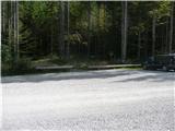 2
2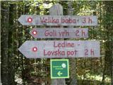 3
3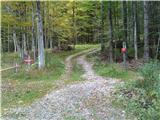 4
4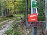 5
5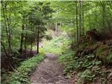 6
6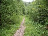 7
7 8
8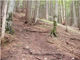 9
9 10
10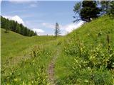 11
11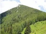 12
12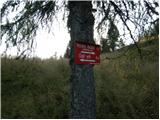 13
13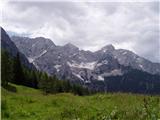 14
14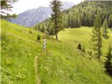 15
15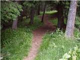 16
16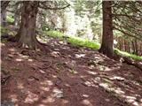 17
17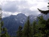 18
18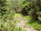 19
19 20
20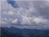 21
21 22
22
Discussion about the trip Ravenska Kočna - Goli vrh (slovenian way)
|
| Gost23. 05. 2007 |
Last summer there was unbearable heat to the summit, on the path through the forest everything was buzzing with flies.
And for consideration - locals call Goli vrh Kačji vrh!! 
|
|
|
|
| Gost6. 06. 2007 |
I was up there but there was no snake, otherwise the view is really wonderful. The path is quite steep in places but fortunately it runs in the shade.
|
|
|
|
| Ratu Lačn31. 07. 2007 |
In autumn - beautiful summit. Nice view, wonderful larches, quite steep but short path, doesn't drag on. Recommended.
|
|
|
|
| Gost21. 01. 2008 |
Regarding the snake, it holds. Especially on hot days,
|
|
|
|
| Gost22. 01. 2008 |
Well, she doesn't get in anyone's way. She's at home there after all. Lp Franc
|
|
|
|
| sebanakis21. 12. 2008 |
Summit reached 19.12, excellent weather conditions, now we've also made a track to the top, so there won't be major problems for the ascent. Lots of snow, no major avalanche risks.
good luck
|
|
|
|
| ana22. 12. 2008 |
Last year I was on this scenic summit in winter and now reading this tempts me to go up again these days. I just wanted to ask where to leave the car. Thanks for the answer.
|
|
|
|
| sebanakis22. 12. 2008 |
at the last farm you can leave the car, you can turn it around nicely, there's enough space for three cars, but don't push further so you don't get stuck like we did, under the snow there's a thick layer of ice, so if you don't have an ice axe, you can't dig to the ground.
|
|
|
|
| klavdy628. 06. 2010 |
Nice and steep path, at the top however a lot of flies disturb the rest.
|
|
|
|
| Parkeljc26. 02. 2011 |
Today some of us went up, initially no sign of sunshine, but closer to the top it showed more, on the top we even had it all the time. It was a bit windy, but still within limits.. Snow from 5-15 cm, snakes still deep in the ground  ! !
|
|
|
|
| free26. 02. 2011 |
parkeljc, how far did it go with the car?
|
|
|
|
| free27. 02. 2011 |
up to the last farm on dry ground, to the starting point with a slightly higher car, but not necessary because it's not far.....
|
|
|
|
| Parkeljc28. 02. 2011 |
We left the car at Anceljna, the last farm.. We were lucky to have a small car, some before us turned around and left their cars a bit lower. Upon return, I noticed that some drove further from Anceljna, even beyond "rogovile", where there are signs for Goli vrh, Češko kočo,..., probably need good winter tires and some experience driving on such a road..
|
|
|
|
| joža x28. 02. 2011 |
From Ancelja to the forest it's a wonderful walk through a truly dreamy landscape, so why stink with cars there? Where is the mountaineering spirit?
|
|
|
|
| EUGEN11. 04. 2011 |
Yesterday on such a nice day we started from Jezerski vrh along the markers via Malenšk (Zeleni vrh) to Goli vrh. Towards the summit still some southern snow and scree, but a very nice and interesting ascent.
|
|
|
|
| abes9. 01. 2012 |
Yesterday at the top, beautiful snowy idyll, great views.
And passing by was Davo Karničar too, even better. 
I would praise the older group that had a great time on the trail, lots of laughter, and "sliding" on their backsides at Jenkova planina. Good spirits count! best regards
|
|
|
|
| alzu11. 02. 2012 |
Yesterday at the summit. Frost, wind, snow, clouds, sun (a bit of everything). As much fresh and wind-packed snow as you want. Path trampled, in some places crusty so snowshoes recommended. Also possible to reach the top with skis.
|
|
|
|
| sirt112. 05. 2012 |
On Wednesday I was up there, weather excellent, Grintovci and Babi like on the palm of your hand. But the question doesn't give me peace: is there any connection (perhaps a border crossing) Jezerski vrh - Goli vrh (Jenkova planina)
Thanks for any information.
|
|
|
|
| Sim7910. 08. 2012 |
This morning I was up there for the first time. After a long time it wasn't so hot, so walking was very pleasant. The path isn't overly steep, but it can be slippery in the forest if wet. The view from the top is wonderful  Judging by the logbook, it doesn't seem to be very popular. Jenkova planina is very overgrown, so parts of the path now, when everything is growing lushly, can't be seen at all Judging by the logbook, it doesn't seem to be very popular. Jenkova planina is very overgrown, so parts of the path now, when everything is growing lushly, can't be seen at all
But I didn't see any snakes
|
|
|
|
| Kokta18. 08. 2012 |
The stamp and logbook are at the top. Very nice view from the "Jezersko balcony". Someone mentioned lots of flies at the top. That's true.
|
|
|
|
| laik12. 09. 2015 |
Tomorrow I'm visiting Jezersko, and I'd like to climb another hill. I'm interested which hill has better views...Goli vrh or Veliki vrh. Thanks a lot for the information and good luck
|
|
|
|
| serajko12. 09. 2015 |
lp
Goli vrh is much more panoramic, but watch out if it is wet.!
|
|
|
|
| gorskarozica10. 12. 2016 |
Lost women's wristwatch, 10.12.2016 on Goli vrh. If someone finds it, please call me at 031 774 081. Thank you!
|
|
|
|
| ločanka27. 12. 2016 |
Summit for all seasons, always panoramic, easily accessible, beautiful, for all life stages!
Gorskarozica, I looked yesterday according to your watch, but I didn't see it!
|
|
|
|
| zajko17. 04. 2018 |
14.4.18 in very sunny and warm weather along this path to Jekova planina, then mostly on the Austrian side to the summit. Lots of snow, but the path is trodden. At the summit sunbathing and enjoyment. See pictures on Martin Škobernet (author Drago Vodušek).
|
|
|
|
| vilmimilmi28. 07. 2018 |
Start 7.20, cars in the parking lot up to about half, but they all went elsewhere I was thinking of going up the Austrian one, but at Jenkova planina I didn't find the signpost (didn't look very hard) - good thing, it turned out the Austrian is better for descent (less steep, and for ascent it would be hard to find where the path branches into the forest (fallen trees). Great view from the top, there are flies but not annoying, no snakes encountered. On the way down 3 groups (1x1, 1x2, 1x3 :-).
|
|
|
|
| vilmimilmi28. 07. 2018 |
correction: I didn't meet any hikers, except 3 groups halfway down the path
|
|
|
|
| PUHIPUHI14. 03. 2019 |
Hello!
Does anyone have fresh information about this path? How is the snow? Is winter gear needed? Is it trodden? Is the parking lot normally accessible? Thanks.
|
|
|
|
| jprim16. 03. 2019 |
Hello!
You can check the conditions in the current conditions section. I think the trail is snow-free, of course towards the saddle and summit you can expect some. I think the trail to the summit is possible without crampons.
Best regards!
|
|
|
|
| tango23. 03. 2019 |
The peak is ideal for such a beautiful day as today's Saturday, and it's no wonder it was quite crowded. The path is time-appropriate, quite muddy in the forest above Jenkova planina. If you don't know where to go on Sunday, Goli vrh is an excellent choice!
|
|
|
|
| tomzl4. 02. 2021 |
Conditions: quite southern snow, in places up to ca. 40cm, no new snowfall. In places the path is poorly trodden, but still manageable without major difficulties.
(If anyone notices a dark blue crampon strap, please contact me, my email is under the lost and found tab).
|
|
|
|
| stanley20. 02. 2021 |
We found a grey XXL rubber crampon on the path. The owner is waiting for it on the fence left of the "house of sweet delights" in front of the inn by the glider lake
|
|
|
|
| golica6. 03. 2022 19:15:47 |
I'm interested, is the road passable to the Goli vrh parking? Probably not much snow at least first half of the trail. Thanks for info
|
|
|
|
| SKatja6. 03. 2022 19:23:02 |
Not drivable, stops a bit before the last house. Adds about 10-15 minutes.
|
|
|
|
| golica6. 03. 2022 19:34:42 |
so, at that last farm with the saw (I think), then flat to the forest and parking?? Thanks, the recorded time means a lot, thanks
Does anyone know the current conditions on the path to the summit?
|
|
|
|
| golica7. 03. 2022 07:41:58 |
thanks for the info.
|
|
|
|
| SKatja8. 03. 2022 20:54:06 |
I saw some post on FB a few days ago and they had crampons
As for time, better add another 15 min. I don't know how fast you are
|
|
|
|
| Marko M28. 04. 2022 18:30:41 |
Hi. Is there still a lot of snow? Are small crampons enough?
|
|
|
|
| J.P.15. 05. 2022 14:35:35 |
|
|
|
|
| mornar7. 08. 2022 21:16:30 |
I'm curious about the condition of the path to Goli vrh, is the path well marked and are there any other features on the path. Thank you and best regards.
|
|
|
|
| mornar8. 08. 2022 08:04:13 |
thank you very much. b.r.
|
|
|
|
| ana_banana7. 01. 2024 20:33:18 |
Has anyone been up there recently? Are small crampons sufficient? Thanks for the reply
|
|
|
|
| Kafetarca13. 01. 2024 21:10:11 |
Today I was up there, the path is trodden, but from Jenkova planina onwards it's quite steep and unpleasant both for ascent and descent. I didn't use crampons because it wasn't frozen, and on that loose snow they wouldn't help much anyway.
|
|
|
|
| plaNinaPirsMajcen15. 04. 2025 19:55:32 |
https://youtu.be/w5tXULOw9ww?si=xSnrRJ5NoUXwbVIQ
Enjoy watching the video🙂
This beautiful peak with royal views 👑 has long been on my wishlist.
It was first planned as an idea for a winter sunset ❄️🌄 with one of my friends, but it was realized as a spring hike with mom, spiced with white crocuses 🤍🌷 and hungry jackdaws 🐦⬛. Still some snow towards the summit for a sample. The panorama is breathtaking 🥳
Best, Nina
|
|
|
|
| Enka17. 08. 2025 19:28:19 |
Pleasantly shady trail that climbs quite steeply right from the start, then the steepness only increases. In dry conditions no problems, in wet it could be interesting. Even in dry, for the descent we chose the path on the Austrian side, which is more pleasant for walking, but the steepness lasts all the way to the forest road leading to Jenkova planina, and there it's still quite substantial.
Goli vrh is really an awesome viewpoint, shame the atmosphere was a bit hazy today. No flies on the summit, and the parking lot at Ravenska Kočna surprisingly almost completely empty.
Worth repeating!
|
|
|
To post a comment you must log in:
If you do not yet have a username, you must first
register.