Ravenska Kočna - Koroška Rinka (Slovenska pot)
Starting point: Ravenska Kočna (1000 m)
| Latitude/Longitude: | 46,38500°N 14,53640°E |
| |
Route name: Slovenska pot
Walking time: 4 h 15 min
Difficulty: very difficult marked way
Via ferrata: B
Elevation gain: 1433 m
Elevation difference along the route: 1453 m
Map: Kamniške in Savinjske Alpe 1:50.000
Recommended equipment (summer): helmet, self belay set
Recommended equipment (winter): helmet, self belay set, ice axe, crampons
Views: 53.486
 | 2 people like this post |
Access to starting point:
From the Ljubljana–Jesenice highway, take the Kranj–east exit and follow the road ahead in the direction of Jezersko. At Zgornje Jezersko, just a little after the gas station, we will notice a road which branches off to the right from the main road (direction Planšarsko jezero). The road then leads us past the mentioned lake and behind it steeply ascends for a short time. Higher up, the road flattens and at the beginning of a large meadow loses its asphalt covering. We then follow the macadam road to a marked larger parking lot.
Route description:
From the parking lot, we continue on the macadam road following the signs »Češka koča, Ledine« and after approximately 15 minutes of walking, we come to a cargo cableway.
From the former parking lot at the cargo cableway, we head onto the path that goes between the two cableways (the lower station of the cargo cableway to Kranjska koča burned down in June 2015) and then slightly upwards. The path soon leaves the forest and continues through the dwarf pines. After some time, the path brings us to a gully named Žrelo. Here we are at a junction, where we continue left (straight is the path through Žrelo), and the path then immediately becomes a climbing path. The path is well secured, but caution is still needed because of wet rocks. The path over the shorter wall is in some parts also quite exposed, but full of nice views. When we climb this part, the path returns to the dwarf pines, through which we then ascend on a well-made path. We continue quite steeply upwards and soon the path through Žrelo joins us from the right. From here to the Kranjska koča hut, we have only a few dozen steps of easy walking.
From the hut, we continue left towards the east in the direction of Ledinski vrh, Mrzla gora and Babe. The path, which is initially quite gentle, brings us to a junction in a few minutes, where we take the right path (left is the climbing path to Babe). The path ahead only becomes slightly steeper and brings us to a somewhat more difficult passage across a rocky section. Here a steel cable assists us, but the passage when dry is not difficult. The path then brings us to the wide slopes below Ledinski vrh, from which there is a nice view towards the glacier below Skuta, which we can see on the right side. The path ahead ascends moderately and brings us to the next marked junction just a few dozen meters before Jezersko sedlo, where we continue right in the direction of Koroška Rinka or Križ (left to Ledinski vrh, Velika Baba, Mrzla gora).
The path ahead ascends moderately over a less steep scree, then joins the path from Logarska dolina.
The path ahead ascends past a natural window and then turns slightly to the right and crosses the steep western slopes on the ascent. The path then turns left and ascends steeply alongside the steel cable. Soon we reach the northern slopes of the mountain and some easy climbing follows on rugged rock without fixed protection. We reach the western slopes again, where the path ascends very steeply again alongside the steel cable. From here there is also a very nice view of the precipitous walls of Skuta. A quite exposed traverse follows along the western side of the mountain, then the path turns left again and ascends almost vertically alongside the steel cable. We reach the northern slopes of the mountain again and a shorter ascent alongside the steel cable follows to the summit of Koroška Rinka.
Ravenska Kočna - Ledine 2:00, Ledine - Koroška Rinka 2:15.

Photos:
 1
1 2
2 3
3 4
4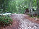 5
5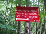 6
6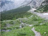 7
7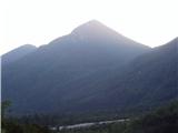 8
8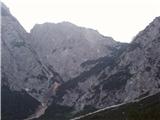 9
9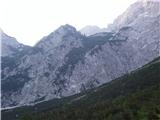 10
10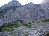 11
11 12
12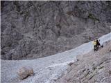 13
13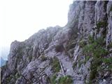 14
14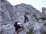 15
15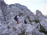 16
16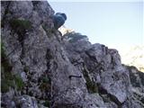 17
17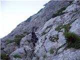 18
18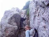 19
19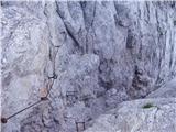 20
20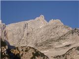 21
21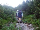 22
22 23
23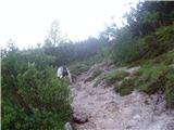 24
24 25
25 26
26 27
27 28
28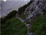 29
29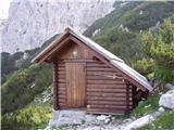 30
30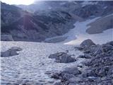 31
31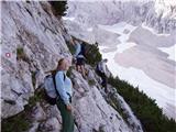 32
32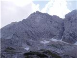 33
33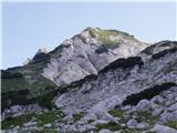 34
34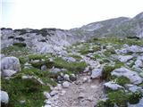 35
35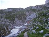 36
36 37
37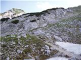 38
38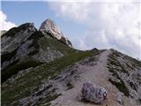 39
39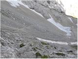 40
40 41
41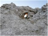 42
42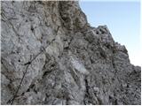 43
43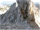 44
44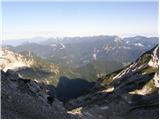 45
45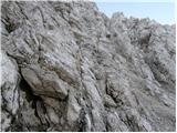 46
46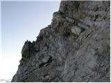 47
47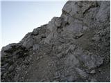 48
48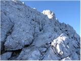 49
49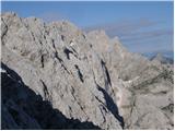 50
50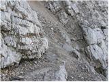 51
51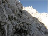 52
52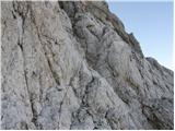 53
53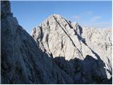 54
54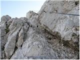 55
55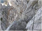 56
56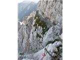 57
57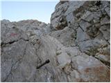 58
58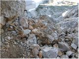 59
59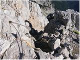 60
60 61
61
Discussion about the trip Ravenska Kočna - Koroška Rinka (Slovenska pot)
|
| oiven16. 07. 2010 |
oh..have a nice day..in the morning I plan to go to Koroška Rinka...hope for some company...
|
|
|
|
| peter skala7. 08. 2010 |
Can someone tell me how much normal walking time it is from Križ-Turski žleb-Skuta-Cojzova koča?
|
|
|
|
| grahelj7. 08. 2010 |
Walking time is approx. 4 to 5 hours.
|
|
|
|
| snežinka14. 08. 2010 |
Hello. I'm interested in how difficult the path to Koroška Rinka is? I read the path description. A week ago I was up žrelu gor, Grintovec and through Slovenska dol - without problems, so I'm wondering if the difficulty level on this path is higher. Thanks for the answer. Best regards
|
|
|
|
| gasperv18. 07. 2011 |
Trail done yesterday. Passable without issues. In the lower section there is some snowfield (with pleasant slope).
Given the clouds rolling over the peaks upon arrival in the valley - early start was a good decision.
regards
G.
|
|
|
|
| urbancek18. 07. 2011 |
If going from Koroška further to Kranjska, I'm wondering if it's necessary to descend to the marked trail, or if there's another path somewhere?
Regards!
|
|
|
|
| nata2418. 07. 2011 |
There is no other path, along the ridge I don't know how it would go  It's not such a big descent anyway, 15 minutes and you're from one Rinka to the other. It's not such a big descent anyway, 15 minutes and you're from one Rinka to the other.
|
|
|
|
| gornica18. 07. 2011 |
I think that for safety reasons it's good to follow the marked trail. True, as nata24 says, it takes a good 15 minutes and you're at Kranjska Rinka. Was up there on Saturday 16.7.2011.
|
|
|
|
| metod2. 08. 2011 |
We were up there yesterday with my daughter and it was nice, only the weather wasn't the most reliable. The considerable exposure in the upper part surprised me, so we went down preferably to Male Pode and to Cojzova. Sure is sure ! !
|
|
|
|
| MRobin19. 08. 2011 |
Today on the path Ravenska Kočna - Slovenska pot - Kranjska koča na Ledinah I lost keys to VW Polo with a small silver key attached. If anyone finds them, please report to 040-860-494.
LP
|
|
|
|
| Janiel7430. 09. 2011 |
Today I went up this path, down via the hunting path over Ledina. Quite a nice climbing path, not too difficult for me as a baby mountaineer Weather was really fantastic Well, only Kranjska koča was already closed.
|
|
|
|
| smatjaz17. 08. 2013 |
Yesterday I ascended from Ledine, the trail is unprotected in some sections and dangerous when wet. The view is fantastic !!! Most of the trail is secured with cables. 
|
|
|
|
| Ceri8. 08. 2014 |
small snowfield before entering the wall of the Slovenska pot to Kranjska koča, meanwhile the path through the gorge is closed due to a landslide
larger snowfield also before entering the Rinka wall, but on a gentler section and thus without risk of slipping
the climbing section is a real treat and therefore pure enjoyment 
|
|
|
|
| z20. 09. 2014 |
Path perfectly equipped. Good trip.
photos
|
|
|
|
| nordkap25. 09. 2014 |
Is it possible to go to Rinka without a via ferrata kit, helmet ok, but not sure about the kit.
What do you think.
|
|
|
|
| mirank25. 09. 2014 |
yes, for sure, and a couple more are living proof that it can be done. How smart that is is another story.
|
|
|
|
| jprim26. 09. 2014 |
For an easier decision, this year in August a jump to Križ, but from Mrzli dol, from where there are many more very demanding paths (- climbing section). That day only three of us were on this path, and the weather was nice. I occasionally used a via ferrata set, but you can't use it on larger sections. If I compare the path from Mrzli dol to the path to Triglav via Plemenice, this one was definitely harder for me. My husband was without protection. Let a smart decision be your first priority.
Best regards!
|
|
|
|
| stropci11. 08. 2015 |
I just want to warn that about 100m below the summit in the climbing section above the gully, a piton is pulled out and it's a bit unpleasant to cross for inexperienced hikers. Additionally, some rocks just below the summit are about to tumble into the valley.
For information.
Good luck!
|
|
|
|
| MarijanB13. 08. 2015 |
This is how this spot looked on 4.8. when we were climbing up. Stay safe and all the best to everyone.
|
|
|
|
| MarijanB13. 08. 2015 |
Sorry, I thought you could upload a picture here.
|
|
|
|
| nikec71. 07. 2018 |
Today walked the path from Jezersko, past Ledin along the Slovenian path and further to Koroška Rinka. The path is extremely interesting and adrenaline-pumping, but extremely dangerous. Very poorly secured and unmaintained, in some places pitons have been pulled out and poor cable... not very pleasant as it's exactly on the most dangerous and overhanging sections. Definitely advise caution. In the lower part there is still a small snow patch, about 200m but nothing dangerous. Just a warning if anyone is setting off on a similar trip soon the view is wonderful
|
|
|
|
| Anansie16. 07. 2018 |
I also did this path on Saturday, didn't seem dangerous anywhere. True, two cable anchors are pulled out, but the cable is still ok since they are pulled out in non-exposed spots. For me only a bit harder - one "overhanging" jump where you swing a bit over the abyss  but weather wonderful, path too, only markings are poorer, so need to be more careful not to miss but weather wonderful, path too, only markings are poorer, so need to be more careful not to miss
|
|
|
|
| Batistuta23. 08. 2018 |
The path from the glacier below Skuta onwards is indeed very demanding, one of the most difficult hiking paths in Slovenia (I'm an experienced mountaineer). As previous posts mention, the markers are very worn, so I constantly lost time with orientation. The wire ropes are torn out in three places, one of them very dangerous. The wire ropes are also damaged and frayed; I scratched my right palm, forearm, and left elbow bloody. The pegs are several times too far apart, requiring some free climbing. In some places it's impossible to walk without dislodging stones; luckily I was completely alone today.
So I recommend the path only for very experienced mountaineers using protective gloves and helmet.
The window along the path is easily accessible and a must-stop, as the view through to the other side of the mountains is fantastic. 5 minutes further from the window I saw a herd of 6 chamois. Beautiful!
At the summit the weather changed in 15 minutes and the descent was a nightmare, as it was raining, thundering, and slipping desperately. I arrived at Ledine completely exhausted. Don't go up unless the forecast is completely clear all day (which in Slovenia never is anyway ).
Happy trails!
|
|
|
|
| Trobec23. 08. 2018 |
So the path is in the same condition as last year.
|
|
|
|
| felix3. 10. 2018 |
At the hut on Ledine there has been a notice for two years that the path to Križ is not maintained and is hiked at one's own risk. I find this completely irresponsible on the part of the Alpine Association of Slovenia, as the SPP runs along this path - some recent SPP variants have been routed from Okrešelj to Ledine and then to Križ, but they do not maintain the path. Also, quite a few other paths where the SPP runs are poorly maintained - the markings are completely faded.
|
|
|
|
| ravnjak4. 10. 2018 |
All paths are maintained by markacists completely for free, and their only reward is our gratitude. If someone wants such comfort in the mountains, it's pointless for them to go up there at all, as they have nicely paved paths in the city. To enjoy reaching the summit, one must make a little effort. I really liked this path and didn't feel like I suffered much up there. All glory and honor to the markacists and trail maintainers, the pegs and cables are exactly where needed, without a bit of climbing it's easier to go for a walk in some park, where everything is arranged and marked with white lines!
|
|
|
|
| felix6. 10. 2018 |
Yes, now I've read something unfamiliar to me!?
I also help with trail maintenance, marking, and I do it all for free too. But trails categorized as marked, especially those along the SPP, must be normally maintained and marked. I also hike unmarked trails, for now I'm not strolling in parks! It is true that there are fewer and fewer people willing to do it for free. Probably in the future, a concessionaire will be found in this area too, who will maintain trails for payment - if PZS and the societies can afford it of course. Best regards!
|
|
|
|
| Stas2. 08. 2019 |
Yesterday I was at Križ (Koroška Rinka). From Ravenska Kočna along the Slovenska pot to the ledine and then to the summit. Return along the same path to Savinsko sedlo then to Ledinski vrh and then to Babe and down to the valley... Super tour, nicely secured otherwise quite airy.. I recommend...
|
|
|
|
| tvodop6. 08. 2019 |
From the window to Koroška Rinka and back is a wonderful path for those who want a bit more. This is not Triglav. Lots of climbing with option to grip pegs and other installed fixtures or natural holds in the rocks (sometimes even that doesn't work where it's crumbly). It really is very exposed and in my opinion not for everyone. Nice day
|
|
|
|
| maks5726. 09. 2019 |
I don't know what to think! Last week I was at Velika Baba from Kranjska koča. In front of the hut there is a warning that says the path to Koroška Rinka is not maintained and walking on it is at your own risk.
But why is Koroška Rinka even in SPP then? On one hand, as someone wrote, the path hasn't been marked for decades, on the other hand, the path is not maintained!?
|
|
|
|
| bbugari126. 09. 2019 |
The question is not why Koroška Rinka is in SPP, but why Kranjska koča is in SPP, instead of the previous variants via Turski žleb, or Tursko Goro?
|
|
|
|
| čebejla26. 09. 2019 |
maks57, obviously there is too much bureaucratic work to remove it
|
|
|
|
| maks5727. 09. 2019 |
It would of course be better to repair the path. But as long as it is as it is, it would really be better to remove it from SPP.
|
|
|
|
| cajer20. 10. 2019 |
We hiked the trail yesterday. To Jezersko saddle without any issues. From the saddle on bad weather started with wind and thick fog. Great caution is needed as the trail is exposed and crumbly. The higher we went, the wetter the cables were, posing a major difficulty on the final vertical climb below the summit. Really dangerous especially on descent, plus at one critical spot the peg is pulled out (??). The descent trail is really not pleasant, at least to the saddle. Further it's nice. Don't go up unless perfectly dry weather is forecast.
For orientation: ascent 4h, descent good 3.5h, both with breaks.
|
|
|
|
| cen11. 08. 2020 |
Protections are currently still in satisfactory condition, except for three bolts at the start of the cables that are loose (not yet a problem since you're pulling upwards). The path is very crumbly, at a few spots you can see there will probably be a larger collapse in the coming years, what happens then is questionable.
If hiking behind another group, give them several minutes lead because stones are constantly flying, almost inevitable, helmet mandatory.
Not recommended for inexperienced, in bad weather or for descent, personally it felt to me on the border between enjoyment and unnecessary risk. I understand why it's no longer maintained because due to rock crumbling it would need constant repair. On the south side the marks are already very faded, high time to renew them.
|
|
|
|
| panoramik11. 08. 2020 |
Interestingly, the path from Mrzli Dol to the junction with the one from Ledine is in good condition, then onwards it's visibly neglected and unmaintained, but it's easily doable up, for down I always go through Turski Žleb.
|
|
|
|
| G_K26. 09. 2021 19:14:59 |
First of all, let me say that the path is not maintained and at Kranjska koča there is a notice that you enter the path at your own risk.
The path is excellently marked, so in clear weather there should be no problems, but it is an extremely crumbly path, a rock slipped under my feet and the handhold stayed in my hand! Ropes are about halfway, half is find your own way... if anything, I recommend SVK and a sober head Good luck!
|
|
|
|
| dvojnit24. 07. 2022 08:01:24 |
The path was repaired in July this year and is safe, but still only suitable for experienced mountaineers!
From the hut to the start of the wire-secured section under the natural window is just under 1 hour of walking (depending on pace), from there to the summit 0:50h, of which the last 15 minutes is a vertical ascent where SVK is very useful.
|
|
|
|
| Kafetarca25. 07. 2022 17:30:44 |
The trail is nicely renovated this year, SVK is fairly unnecessary, highly recommend helmet. Rocks fly constantly, watch out not to slip. Compared to last year's ascent, this one seemed easier because cables at tricky spots were actually tensioned and held upward pull.
Despite protections, the trail is harder than some others with same rating, needs caution and deliberate steps on ascent and descent. But true, the trail isn't boring...
|
|
|
|
| smatjaz26. 07. 2022 17:18:25 |
Helmet and SVK are highly recommended, as it's a "trick" question what you'll do if a stone flies onto your helmet or hand in the wall? Under my guidance, participants must have SVK and helmet. Everyone knows for themselves.
|
|
|
|
| Tajka674. 09. 2024 21:01:31 |
Path hiked and climbed. All praise to the path maintainers. New signs, refreshed markings, reworked path... Downhill via the hunting path, which was harder for me, also maintained, lots of steps. Krajnska koča will be spruced up next season, they finished ceramics today. Oh, parking for the whole day 10 euros, last year still free.
|
|
|
To post a comment you must log in:
If you do not yet have a username, you must first
register.