Ravenska Kočna - Kranjska koča na Ledinah (through Žrelo)
Starting point: Ravenska Kočna (1000 m)
| Latitude/Longitude: | 46,38500°N 14,53640°E |
| |
Route name: through Žrelo
Walking time: 2 h
Difficulty: very difficult marked way
Elevation gain: 700 m
Elevation difference along the route: 700 m
Map: Kamniške in Savinjske Alpe 1:50.000
Recommended equipment (summer): helmet, self belay set
Recommended equipment (winter): helmet, self belay set, ice axe, crampons
Views: 38.705
 | 4 people like this post |
Access to starting point:
From the Ljubljana–Jesenice highway, take the Kranj–East exit and continue along the road towards Jezersko. In Zgornje Jezersko, just a little after the gas station, we will notice a road that branches off to the right from the main road (direction Planšarsko jezero). The road then leads us past the mentioned lake and behind it steeply ascends for a short time. Higher up, the road flattens and at the beginning of a large meadow loses its asphalt surface. We then follow the macadam road to a marked larger parking lot.
Route description:
The described path is closed due to a collapse and destroyed safety equipment in the section through Žrelo from autumn 2020 until further notice.
From the parking lot, we continue on the macadam road following the signs »Češka koča, Ledine« and after approximately 15 minutes of walking, we come to a cargo cableway.
From the former parking lot at the cargo cableway, we continue following the signs Kranjska koča na Ledinah – through Žrelo. At first for a short time, we walk through the forest, then the path brings us to grassy terrain which is partly covered with dwarf pines. Here the path turns slightly to the left and then ascends diagonally beside sparse dwarf pines, later over scree. Such a path brings us to the first junction, where the path towards Češka koča (Umik žrela) branches off to the right. The junction is marked with the inscription »Češka koča« on a rock. Already after a few tens of meters of ascent, we are again at a junction. This time, Slovenska pot branches off to the left into the wall. We continue slightly right and begin to ascend on steep scree upwards. On this part of the path, there can still be a snow patch even in late summer. In the upper part of the scree, the path from Češka koča (through Žrelo) joins us from the right. Here we continue left and soon enter the gully named Žrelo. Due to the very high risk of falling rocks, helmet use is mandatory on the ascent through the gully.
In the gully, we first ascend diagonally along the steel cable, then a short very steep ascent follows right upwards. Assisting us are slightly downward-curved pegs and the steel cable. Next follows crossing to the left over a somewhat gravelly slope and then ascent along the steel cable up the gully. In the last part, the gully becomes somewhat steeper and besides the steel cable, some pegs and staples assist us. From the gully, we then exit left upwards with the help of some pegs and the path becomes easier again.
After a few meters, Slovenska pot joins from the left and an undemanding ascent to Koča na Ledinah follows.

Photos:
 1
1 2
2 3
3 4
4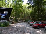 5
5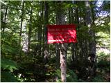 6
6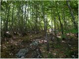 7
7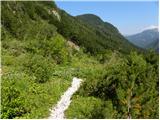 8
8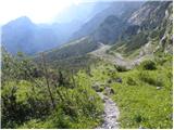 9
9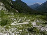 10
10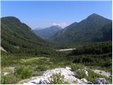 11
11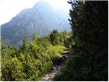 12
12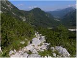 13
13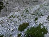 14
14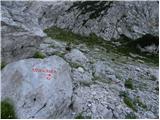 15
15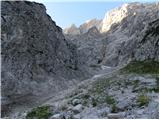 16
16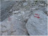 17
17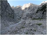 18
18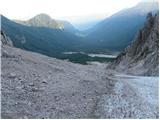 19
19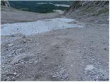 20
20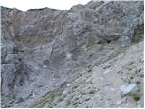 21
21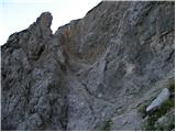 22
22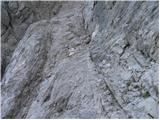 23
23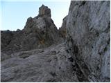 24
24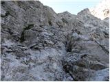 25
25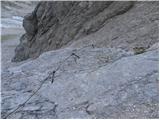 26
26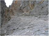 27
27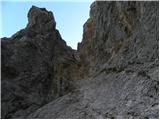 28
28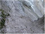 29
29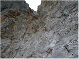 30
30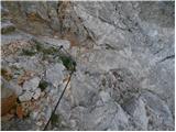 31
31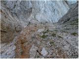 32
32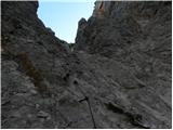 33
33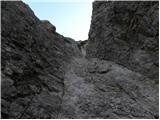 34
34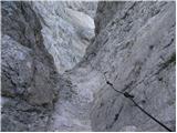 35
35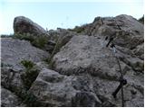 36
36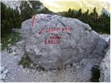 37
37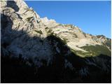 38
38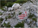 39
39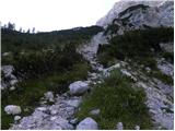 40
40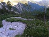 41
41 42
42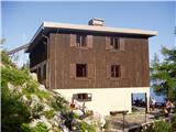 43
43
Discussion about the trip Ravenska Kočna - Kranjska koča na Ledinah (through Žrelo)
|
| jersy26. 08. 2008 |
And maybe someone knows if the path can be compared to Hanz’s on Mojstrovka. Thanks for the clarifications.
|
|
|
|
| panda26. 08. 2008 |
What, have you only done this one path, that you always use it for comparison?
Take a look at the descriptions of approaches to mountains, read the path descriptions and compare them a bit yourself (there are also attached photos, look at them, compare difficulties, times). Only then will possible questions arise that you’ll want answers to.
PS: So you don’t ask next time how many pegs are on this or that path and if there are any ropes. Take this as well-intentioned advice.
|
|
|
|
| EUGEN10. 09. 2009 |
With dog down through Žrelo, never again.
|
|
|
|
| skorny24. 09. 2009 |
The path is quite fine, if you have a climbing harness with you so your head works better. I went on Monday with a friend who was going through the chimneys for the first time, but he had a harness and helmet and it went without problems.
|
|
|
|
| klavdy626. 09. 2009 |
Very nice trip. Went for the first time through the chimneys without problems. Crampons would be useful on the snowfield.
|
|
|
|
| jersy27. 06. 2010 |
Has anyone been on the mentioned trail? Snow? Wires?
|
|
|
|
| anemona25. 07. 2010 |
On Wednesday, 21.7., my daughter and I went from the cargo station of both cable cars to Češka koča and through Žrelo to Ledine. We didn't have ice axe and crampons (helmet mandatory), so we were prepared for return if we couldn't cross Žrelo. The glacier really showed its teeth (snow only up top at the start of the glacier for sample), now there's hard ice there, sprinkled with pebbles. But since the glacier itself is no longer very big, we descended 30-40m and bypassed it. Carefully on the loose sand by the glacier up and down! Further on without problems, cables, pegs and staples on both sides of Žrelo in excellent condition, same on the hunting path by which we descended from Ledine back to the cargo cable car.
|
|
|
|
| efes27. 08. 2010 |
Today I went up this path, I recommend it to everyone who is not afraid of those few fixed ropes (my rating - easy marked path), next time I'll go up the Slovenska pot .
|
|
|
|
| efes28. 08. 2010 |
primoz, no, I agree with you.
|
|
|
|
| roker630. 03. 2012 |
Still quite some snow, it goes without crampons and ice axe too, helmet mandatory though, chamois triggered a whole barrage of rocks, otherwise no issues.
|
|
|
|
| samoa5. 06. 2012 |
What are the conditions through Žrelo, is there still a lot of snow? If anyone has walked there these days, please share information.
|
|
|
|
| mary6. 06. 2012 |
The path is normally passable. Regards.
|
|
|
|
| Gamsss8. 10. 2012 |
On Saturday 8.10., walked this path, the path is nicely passable. Regarding the difficulty rating, I think it's exaggerated. My rating (easy marked path).
|
|
|
|
| mkrasev13. 07. 2013 |
Dear gamsss, because of comments like yours, serious accidents can happen, and mountains can be resented forever, keep your thoughtless chatter to yourself, leave the path rating to mountaineering experts and guides who know how to professionally assess the path. I walked it myself, unfortunately without safety gear, the path is demanding and dangerous in places, so don't put hikers in danger with your stupid difficulty ratings. That's all. Good luck to all.
|
|
|
|
| čemšeničan21. 07. 2014 |
On Saturday I went towards Ledine via Slovenski gor to the top of Rink, back I planned to return through Žrelo but the hut keeper at the hut on Ledine told me that the path through Žrelo is closed and prohibited, since I follow advice I returned to the valley via the hunting path.
|
|
|
|
| Mokara17. 06. 2015 |
Hello, I'm wondering if the path from Ledine through Žrelo to Češka koča is now normally passable or still closed.
Thanks for the answer!
|
|
|
|
| Matej_K.17. 06. 2015 |
The path is still closed, the cables are damaged, torn, at the top a landslide is visible from which more could fly out.
|
|
|
|
| Mokara18. 06. 2015 |
Thanks Matej. Do you know maybe some similar path around there to "climb" a bit? Up we'd go the Slovenian. Is there a circular one with more "ropes and pegs"?
|
|
|
|
| Matej_K.18. 06. 2015 |
You can try the new ferrata to Češka koča. To Ledine, the Slovenian is still the most "climbing", via the hunter's you return back to the starting point. Or wait until autumn when apparently they'll also set up a new ferrata to Ledine.
|
|
|
|
| garmont9. 11. 2015 |
The trail through Žrelo has now been rebuilt and runs along the left side of the gully and no longer on the right. However, in the upper part it is more demanding than the old trail and requires quite some care, especially at the place where there are no footrest pegs.
|
|
|
|
| Behemot1. 08. 2016 |
Hiked the path through Žrelo with daughter the day before yesterday. The path is substantially more demanding in the upper section than the old one and I wonder if it isn't currently the hardest among longer hiking paths in Savinja Alps.
|
|
|
|
| Kranj27. 08. 2017 |
There are three paths: hunting, Slovenian, Žrelo that lead to Ledine. You went through Žrelo, via ferrata is a completely different thing that leads to Češko. Regards
|
|
|
|
| sirt128. 08. 2017 |
Secured climbing paths (called via ferratas in foreign languages) are very demanding hiking paths that are equipped with safety devices and iron aids along most of their length. The purpose of equipping secured climbing paths is to enable access to the most demanding summits or over walls also for hikers without mountaineering knowledge.(wikipedia)
Kranj, explain why the path through (not over) Žrelo (written with capital) is not a via ferrata. Not enough iron, or not difficult enough?
|
|
|
|
| jvali15. 07. 2018 |
On Saturday, 14.7. via Slovenska to Ledine and also descent via Slovenska then ascent to Češka. The path through Žrelo is CLOSED. So ascent through Žrelo next time, when they repair the torn cable and the path is officially passable.
|
|
|
|
| Laura949. 08. 2018 |
Hello,
Since just under a month has passed since the announcement that the path through Žrelo is closed, I wonder if the path has been repaired yet?
We plan to go first to the Czech hut and from there to Ledine. If the path through Žrelo is closed - at the junction for the Slovenian path, do you completely descend back to the valley before ascending to Ledine or not? I have gone through Žrelo once so I know that path, but I don't remember how it is on the Slovenian one thanks!
|
|
|
|
| NYG9. 08. 2018 |
You descend over 200 m, no big deal.
|
|
|
|
| garmont9. 08. 2018 |
When continuing from the Czech hut, you'll notice the inscription “Umik Žrela” on a rock, which leads you left downwards towards the “Slovenian path”. The loss of elevation is not too great.
|
|
|
|
| Enka10. 08. 2018 |
The path through Žrelo is closed, via Umik Žrela and the Slovenian one is a nice (of course much easier) variant to Ledine. The loss of altitude is negligible, as others have already written.
|
|
|
|
| matic429. 07. 2020 |
The path is officially closed. Access to the wall is difficult over hard scree, below the cables are torn or missing, you hike through dense slopes below without protections. In the upper part all protections are impeccable (where you really need them). Passage is thus possible (for experienced), but ONLY AT YOUR OWN RISK!
|
|
|
|
| felix27. 08. 2020 |
The path has been closed for two years already. More and more paths are closed (to Koroška Rinka, Kočno). Are these paths not going to be maintained anymore? New vias ferratas are opening. Something doesn't make sense to me about how the responsible ones view the whole thing!
|
|
|
|
| karibu27. 08. 2020 |
If it says on PZS then it holds.
|
|
|
|
| alenkaj26. 06. 2021 14:45:50 |
Hello, I'm interested in the difference between the Slovenska pot and the trail through Žrelo? Both are climbing trails, which one is harder? Best, Alenka
|
|
|
|
| Climber9126. 06. 2021 16:52:05 |
To me they are almost equal, Žrelo more crumbly. But Žrelo is still closed, if I'm not mistaken??  if pegs and cables bother you, don't go on either of these, because there are quite a few and both are exposed. if pegs and cables bother you, don't go on either of these, because there are quite a few and both are exposed.
|
|
|
|
| alenkaj26. 06. 2021 22:01:00 |
Climber, thanks for the explanation, the pegs and slings are great for me, I just didn't know the difference between these two paths, ok I'll go via the Slovenska one, I'll check if Žrelo is open. Oh and one more thing, have you maybe been on this path this year, is there still snow and is SVK absolutely necessary? Regards Alenka
|
|
|
|
| Climber9127. 06. 2021 06:38:57 |
Not this year yet, I think about a week ago someone was on Ledinski vrh, via Slovenska to Ledine and didn't need gear.
No SVK needed, just helmet.
Žrelo is a great connection Češka koča-Ledine. Wait a bit, if the path reopens, do the ferrata tour Češka koča - Žrelo to Ledine, walk to Ledinski vrh
|
|
|
|
| bbugari14. 08. 2025 17:58:55 |
Does anyone know where the SPP stamp from Kranjska koča is?
|
|
|
|
| mornar5. 08. 2025 12:34:45 |
The stamp is in the box under the shelter-
|
|
|
To post a comment you must log in:
If you do not yet have a username, you must first
register.