Ravenska Kočna - Kranjska koča na Ledinah (via Češka koča)
Starting point: Ravenska Kočna (1000 m)
| Latitude/Longitude: | 46,38500°N 14,53640°E |
| |
Route name: via Češka koča
Walking time: 2 h 30 min
Difficulty: very difficult marked way
Elevation gain: 700 m
Elevation difference along the route: 780 m
Map: Kamniško Savinjske Alpe 1:50.000
Recommended equipment (summer): helmet, self belay set
Recommended equipment (winter): helmet, self belay set, ice axe, crampons
Views: 52.832
 | 3 people like this post |
Access to starting point:
From the Ljubljana - Jesenice highway, take the exit Kranj - East and follow the road ahead in the direction of Jezersko. At Zgornje Jezersko, just a little after the gas station, we will notice a road which branches off to the right from the main road (direction Planšarsko jezero). The road then leads us past the mentioned lake and behind it steeply ascends for a short time. Higher up, the road flattens and at the beginning of a large meadow loses its asphalt surface. We then follow the macadam road to a marked larger parking lot.
Route description:
The described path is closed due to a landslide and destroyed safety equipment in the section through Žrelo from autumn 2020 onwards.
From the parking lot, we continue on the macadam road following the signs »Češka koča, Ledine« and after approximately 15 minutes of walking, we come to a cargo cableway.
At the cableway, the path goes behind the bottom station of the cableway in the direction of Češka koča and initially gently ascends on a wide path, which in a few minutes brings us to a larger clearing. The path over this clearing is usually quite muddy, so be careful. After 20 minutes of walking, the path brings us to an indistinct small ridge, where there is a bench. The path then continues through the forest and after a further 20 minutes brings us to a junction, where from the right the path from the meadow (lower starting point) joins. We continue left and already after a few more steps we reach the next junction, where from the right the path from Makekove Kočne (neighbouring valley) joins. The path then leaves the forest onto scenic slopes, where with the help of some steel cables and a ladder we ascend towards Češka koča (Hudičevi klanci). This part of the path when dry is not difficult and does not pose greater danger (greater caution is needed in late autumn when the gullies are icy and in winter when there is snow). The path then flattens and brings us to Mrzla dolina (1500 m), where cold air often lingers. Only a good 5 minutes' moderate ascent follows and the path brings us to Češka koča na Spodnjih Ravneh.
From Češka koča we follow the signs to Ledine. Initially the path leads along sparse dwarf pines towards the east and then becomes somewhat more demanding. A short crossing with the help of a steel cable under rock overhangs follows, then for some time along the steel cable we cross a slightly exposed slope towards the east. Later the path descends slightly and brings us to a junction below steep walls. To the left downwards leads the path to the bottom station of the cargo cableway and to Ledine via Slovenska pot. We continue straight ahead and enter the wall. Here the path becomes even more demanding and with the help of a steel cable and some brackets steeply ascends. We then ascend a well-secured steep ledge into which steps are carved. When we cross a narrow rocky passage we cease ascending and then mostly in a slight descent cross the exposed slope.
The path further brings us to a steep scree field on which there can still be a snow patch even in late summer. After crossing the scree, the direct path from the bottom station of the cargo cableway joins from the left.
Here we continue straight and soon enter a gully called Žrelo. Due to the very high risk of falling rocks, helmet use is mandatory on the ascent through the gully.
In the gully we first ascend diagonally along the steel cable, then a short very steep ascent follows rightwards upwards. Slightly downward-curved pegs and the steel cable assist us. A crossing to the left follows over a slightly gravelly slope and then an ascent along the steel cable up the gully. In the final part the gully becomes somewhat steeper and in addition to the steel cable some pegs and brackets assist us. From the gully we then exit leftwards upwards with the help of some pegs and the path becomes easier again.
After a few metres the Slovenska pot joins from the left and an easy ascent to the hut on Ledine follows.
Ravenska Kočna - Češka koča 1:30, Češka koča - Kranjska koča 1:00.

Photos:
 1
1 2
2 3
3 4
4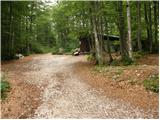 5
5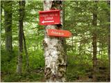 6
6 7
7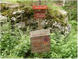 8
8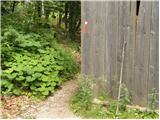 9
9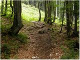 10
10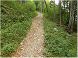 11
11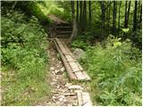 12
12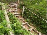 13
13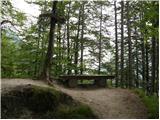 14
14 15
15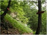 16
16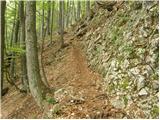 17
17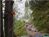 18
18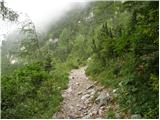 19
19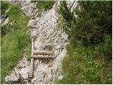 20
20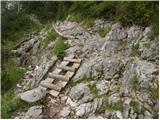 21
21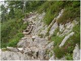 22
22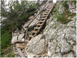 23
23 24
24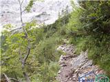 25
25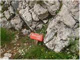 26
26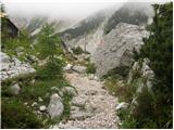 27
27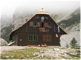 28
28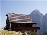 29
29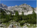 30
30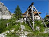 31
31 32
32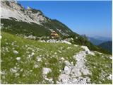 33
33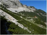 34
34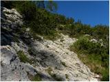 35
35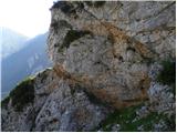 36
36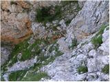 37
37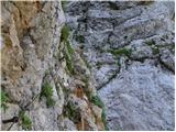 38
38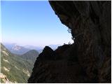 39
39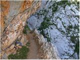 40
40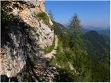 41
41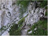 42
42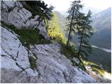 43
43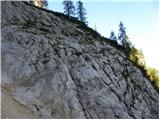 44
44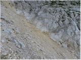 45
45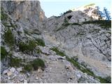 46
46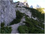 47
47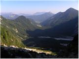 48
48 49
49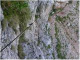 50
50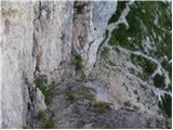 51
51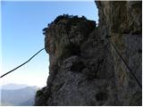 52
52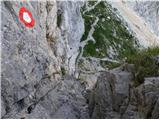 53
53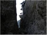 54
54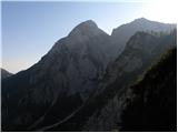 55
55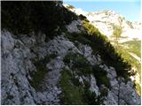 56
56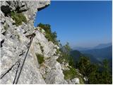 57
57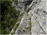 58
58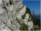 59
59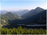 60
60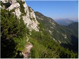 61
61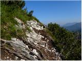 62
62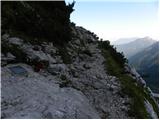 63
63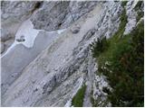 64
64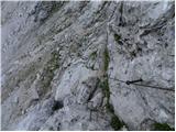 65
65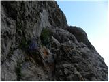 66
66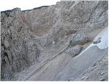 67
67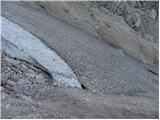 68
68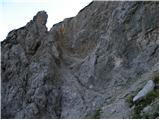 69
69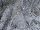 70
70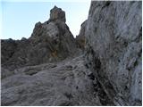 71
71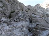 72
72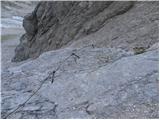 73
73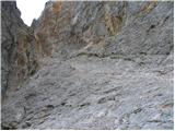 74
74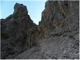 75
75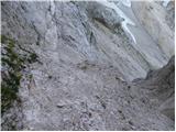 76
76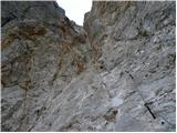 77
77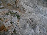 78
78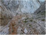 79
79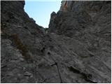 80
80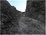 81
81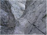 82
82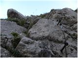 83
83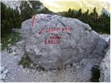 84
84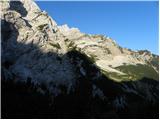 85
85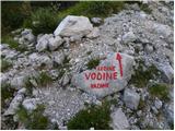 86
86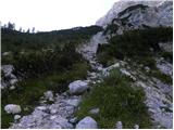 87
87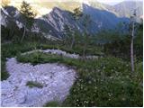 88
88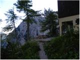 89
89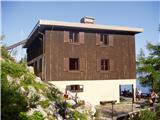 90
90
Discussion about the trip Ravenska Kočna - Kranjska koča na Ledinah (via Češka koča)
|
| enot30. 07. 2010 |
This is, in my opinion, one of the most beautiful hiking trails.
|
|
|
|
| Bond30. 06. 2011 |
Today I went with a friend for the first time on this path and was thrilled by it. Only somewhat annoying are torn wire ropes in "žrelo" (and also earlier spots), recommend extra caution. Urge authorities to fix wire ropes to avoid accidents.
|
|
|
|
| katty7. 10. 2011 |
On this rainy day I'm remembering one of the paths I've hiked. This was one of the nicer and more, if not the most, adrenaline-filled . I did it on 13.8. The whole time nice sunny weather accompanied me . I did it on 13.8. The whole time nice sunny weather accompanied me , which then, when my dad and I were cooling off with beer at Davo Karničar in the mountaineering center, worsened considerably and it was already raining , which then, when my dad and I were cooling off with beer at Davo Karničar in the mountaineering center, worsened considerably and it was already raining . Great hike, not strenuous, but quite adrenaline-pumping, especially the part of the path when we returned from Ledine to the cable car station via the Slovenska pot. Still, I was glad we went to this part of KSA, mainly to get used to the fixed cables and pegs again . Great hike, not strenuous, but quite adrenaline-pumping, especially the part of the path when we returned from Ledine to the cable car station via the Slovenska pot. Still, I was glad we went to this part of KSA, mainly to get used to the fixed cables and pegs again . .
In short, it was great, next year probably from the Lovska route. And in the opposite direction, towards Češka koča.
|
|
|
|
| Stane714. 06. 2012 |
Does anyone know if there's still any snow on the path (between the two huts)?
|
|
|
|
| petruša14. 06. 2012 |
No snow left at all, the path is dry, because I called the Češka koča today and asked, and the friendly gentleman said that hikers are walking and say it's dry. Since we're also setting off on this path on Saturday. lp
|
|
|
|
| Stane715. 06. 2012 |
Thanks, maybe we'll meet then.
|
|
|
|
| janeGOR15. 08. 2012 |
Yesterday from the cable car to Češka koča I arrived at the goal all excited. Through the forest it is quite steep, from the forest onwards pure beauty and an excellently maintained and protected path. Friendly caretakers, nice view, then I too quickly decided to jump to Kranjska koča na Ledinah via Žrelo. I am 64 years old and without center, plus backpack with poles adds at least 5kg. I have already walked paths with steel cables and pegs, but this path is really demanding and requires 100% attention all the time. Ideal weather, over the scree I heard stones rattling above me, the hardest was the passage over the rock in the last third of Žrelo, when I literally had to pull myself up. I don't take away anyone's will, I'm never scared either, but really cautiously. It took me two hours for this jump to Kranjska koča na Ledinah via Žrelo. I am 64 years old and without center, plus backpack with poles adds at least 5kg. I have already walked paths with steel cables and pegs, but this path is really demanding and requires 100% attention all the time. Ideal weather, over the scree I heard stones rattling above me, the hardest was the passage over the rock in the last third of Žrelo, when I literally had to pull myself up. I don't take away anyone's will, I'm never scared either, but really cautiously. It took me two hours for this jump Maybe easier in the opposite direction? Down from Ledin is another story, which today's muscle ache reminds me of... Maybe easier in the opposite direction? Down from Ledin is another story, which today's muscle ache reminds me of...
|
|
|
|
| Tinkerbell7. 06. 2014 |
Does anyone know if there is still any snow up there now?
|
|
|
|
| Branee8. 06. 2014 |
Last Thursday there was still plenty of it.
|
|
|
|
| _d_19. 06. 2014 |
Does anyone have new information about the path between Češka koča and Koča na Ledinah? Is it snow-free?
|
|
|
|
| sirt119. 06. 2014 |
Žrelo will remain snowy for some time yet.
Avoiding Žrelo and taking the Slovenska pot, we still have to cross snow there below the entry into the wall.
|
|
|
|
| _d_19. 06. 2014 |
Thanks, we'll postpone this trip for a while, since we planned a loop up the Slovenska to koča na Ledinah, through žrelo back to Češka koča. It will be more suitable when the snow melts.
|
|
|
|
| _sandra_20. 06. 2014 |
Slovenska pot is snow-free, you only cross a bit of snow just before the wall entry, which isn't frozen and isn't dangerous. Žrelo is "closed", if you go, take Slovenska up and down, another option is the hunting path which was on 10.6. still partially snowy right below the koča.
|
|
|
|
| Škorpijon A4. 08. 2014 |
I'm curious what the path through Žrelo is like now? Thanks in advance.
|
|
|
|
| ljubitelj gora4. 08. 2014 |
A bit lower the Slovenska pot goes (picture 63), if the passage through the gully is closed.
|
|
|
|
| jvali11. 10. 2014 |
Tomorrow, to make the most of the nice weather, my husband and I (probably) will head out on this trail. So, first Češka koča, then to Ledine, but probably via the Slovenian path since Žrelo is closed. Is that still true? Does anyone have new information, it would be very useful to us. From Ledine back to the starting point, so it's a circular trail, right? Any suggestions from hikers who have experience with this trail? Thanks and happy trails. val.
|
|
|
|
| lucky11. 10. 2014 |
Žrelo is still closed, first to Češka koča then along the path that goes lower (Žrelo bypass) and then Slovenian towards Ledine and back to the starting point. Nice circular trail, I recommend.
|
|
|
|
| jvali11. 10. 2014 |
lucky: thanks for the quick reply. tomorrow both huts are open for the last time this season. that's also worth taking advantage of.
|
|
|
|
| marko hribinet21. 07. 2015 |
Hi. Can someone please tell me the condition of the path between Češka koča and Kranjska koča. Is Žrelo still closed or what is the alternative? Do you need to descend a bit for the Slovenska, if I understand correctly? Thank you!
|
|
|
|
| Kokta21. 07. 2015 |
The path through Žrelo is still closed. For Slovenska you need to descend a bit. Large marking is visible at the entrance.
|
|
|
|
| jojo5411. 08. 2015 |
In the next few days I plan to take this route: first from the parking lot to the Czech hut, then crossing to Kranjska hut on Ledinah and back to the parking lot. I'm interested (given the closed Žrelo), approximately how many "m" one has to descend and then ascend again to reach Kranjska? Is it then the ascent via Slovenska or some other path?
|
|
|
|
| sirt112. 08. 2015 |
First descend the path - Češka koča (Žrelo bypass). Descent approx. 200 m. Then ascend via Slovenska.
Good luck
|
|
|
|
| jojo5412. 08. 2015 |
Thanks a lot, sirt1!
If I understood correctly, from Češka (Žrelo bypass) descent of approx. 200 m, then approx. 400 m re-ascent to Kranjska?
|
|
|
|
| Kokta31. 08. 2015 |
The path through Žrelo is open, but now more demanding.
|
|
|
|
| sirt11. 09. 2015 |
How did they route it through Žrelo? It used to be through Žrelo!
|
|
|
|
| gornica1. 07. 2016 |
Hi, I'm interested if anyone has done this hike recently. What are the conditions on the path (snow, crossing Žrelo)? Thanks and happy trails.
|
|
|
|
| sirt11. 07. 2016 |
No passage through Žrelo!
|
|
|
|
| zokipoki19. 07. 2016 |
Is the path through the gully passable?
|
|
|
|
| redbull19. 07. 2016 |
all paths are passable, it just depends on how you take them or approach them
|
|
|
|
| zokipoki21. 07. 2016 |
Yes it is thanks for the info
|
|
|
|
| Saš196723. 07. 2017 |
Yesterday with the family we did this extremely beautiful and varied circular tour. We skipped Žrelo and ascended to Kranjska koča and then descended via Slovenska pot. Huge number of hikers, views really wonderful. We will surely return when we go a bit higher.
|
|
|
|
| garmont22. 08. 2017 |
A correction of the route description through Žrelo will also be needed here.
The route is now routed on the left side and is significantly more demanding than the old route.
|
|
|
|
| timgalema20. 10. 2017 |
I'm interested how the route is: 'is the passage through the gully open, do you need to have a via ferrata set? I know it's recommended.
thanks
|
|
|
|
| redbull21. 10. 2017 |
The path is very good, secured.
|
|
|
|
| J.Grega2. 11. 2018 |
Hello mountaineers!
Perhaps tomorrow or on Sunday I would like to head past Češka koča towards Kranjska koča na Ledinah, is the path normally passable? Is there any snow on the mentioned path?
Thank you very much! Mountaineer's regards
|
|
|
|
| megla3. 11. 2018 |
I don't know the current condition, but the path through Žrelo was closed on 28.8.2018.
Regards
|
|
|
|
| Domch5. 11. 2018 |
The path is a landslide in installments. There are fixed protections, but the terrain is so crumbly that you never know if it will hold under your feet or not, especially towards the top.
|
|
|
|
| umetnik0074. 08. 2019 |
Today I did this trail. I didn't notice the notice that it's closed in time. Already to the gully the trail is covered with debris in many places and has to be searched for. Through the gully it's crumbly, here and there safety gear is missing, some of it is nicely bent. Quite adrenaline-pumping, but when it was behind us, the feeling was quite victorious.
|
|
|
|
| orchigu19. 06. 2023 13:42:28 |
Here's an update... today spoke with the hut warden. This path has been closed for years already, because avalanches and rockfalls constantly occur and destroy the fixed protections. So the fact that the path is closed is still current information. PZS could mark it on their site soon. 
|
|
|
|
| AndrejS19. 06. 2023 15:26:43 |
This path is marked as closed on maPZS https://mapzs.pzs.si/home/trails.
If there is no longer a "PATH CLOSED" sign at the start of the path, inform the maintainer of this path about it, probably PD Jezersko.
|
|
|
|
| Enka19. 06. 2023 23:25:04 |
|
|
|
|
| Kafetarca16. 08. 2023 21:56:55 |
Checked with PZS today and apparently one part of this trail is open, it's closed only on the section through Žrelo...Trail Češka koča-Ledine
|
|
|
|
| bongo17. 08. 2023 08:58:50 |
The path through Umik žrela is open, but it was discouraged about a month ago due to a large rock on the scree. In this case, the usual access to Slovenska na Ledine from Češka koča is (was) impossible. Additionally, the section to the very entrance to Žrelo is closed on this path (which doesn't matter, since the latter is closed anyway). From Češka koča, you go along the path towards Ledine and at the junction in the ključi you descend to the lower path that continues along Slovenska. Everything is marked, and for adventurers, info that the path through Žrelo is in its usual state (fully passable, but at your own risk).
|
|
|
|
| Kafetarca17. 08. 2023 09:17:30 |
Bongo, thanks for the explanation. I was convinced all the time that the connection between the huts is impassable, but I see I had it all a bit mixed up.
|
|
|
|
| maartin4. 07. 2024 10:55:35 |
Does anyone know if the path is dry or if there's some gully somewhere where winter gear is needed? Of course the northern one, the other is closed.
|
|
|
To post a comment you must log in:
If you do not yet have a username, you must first
register.