Ravenska Kočna - Velika (Koroška) Baba (via Jenkova planina)
Starting point: Ravenska Kočna (1000 m)
| Latitude/Longitude: | 46,38470°N 14,53640°E |
| |
Route name: via Jenkova planina
Walking time: 3 h 30 min
Difficulty: difficult marked way
Elevation gain: 1127 m
Elevation difference along the route: 1160 m
Map: Karavanke - osrednji del 1:50.000
Recommended equipment (summer): helmet
Recommended equipment (winter): helmet, ice axe, crampons
Views: 66.332
 | 8 people like this post |
Access to starting point:
From the Gorenjska motorway, via Kranj or Preddvor, we drive to Zgornje Jezersko, then approximately 1 km after the Petrol filling station, we turn right in the direction of Planšarsko jezero and Češka koča. Further on, we drive past the mentioned lake, then the road leads us across a larger meadow, where the asphalt ends and from which a beautiful view opens up on the surrounding mountains, then the road returns into the forest, where it first crosses a torrent. A little further ahead, the road splits, and we continue on the right road (left: Gorniški center Davo Karničar and also the footpath to Jenkova planina and the former starting point for the mentioned mountain pasture), along which we quickly arrive at a large marked parking lot, where we park.
Route description:
Somewhere in the middle of the large parking lot a passage opens to the left, by which there are mountaineering signs for Velika Baba, Goli vrh and a sign for the hunting path to Ledine. We start the path on a cart track which brings us to the edge of a meadow, where on the left side we will spot the Gorniški center. We continue straight to the well-visible signs at the nearby junction, from which we continue straight in the direction of Velika Baba and Goli vrh (right Ledine). The path ahead still leads us on a cart track, which soon turns left, and further on ascends diagonally. Higher up, the path from the old starting point joins us from the left, i.e. the marked path from Planšarsko jezero. The cart track on which we walk then turns into a footpath, which ascends relatively steeply through the forest. After approximately an hour and a half of walking, we step out of the forest onto the abandoned and quite overgrown Jenkova planina.
On the planina we arrive at a junction, where we head right towards Velika Baba. The path initially runs across the meadows on the planina, then brings us into the forest, where it begins to ascend steeply. The path runs along the right (western) side of the ridge and continues ascending through increasingly sparse forest. The forest transitions into dwarf pines and on steep slopes we soon reach the border ridge. The path then runs along a quite narrow and unsecured ridge and brings us to Mala Baba (2014 m). Here the path becomes somewhat more demanding, and at a few spots also somewhat crumbly and exposed. Such a path, which continues along the ridge, brings us to the summit of Velika Baba in a few shorter descents and ascents.

Photos:
 1
1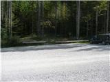 2
2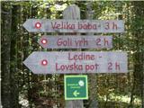 3
3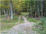 4
4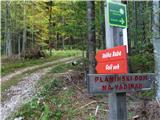 5
5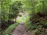 6
6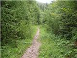 7
7 8
8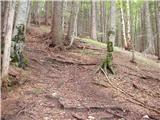 9
9 10
10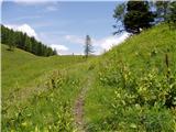 11
11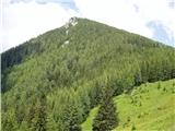 12
12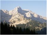 13
13 14
14 15
15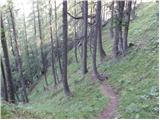 16
16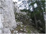 17
17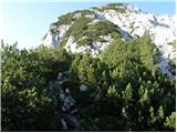 18
18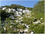 19
19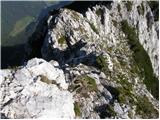 20
20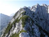 21
21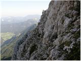 22
22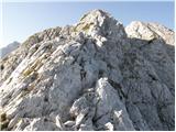 23
23 24
24 25
25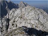 26
26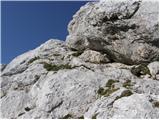 27
27 28
28
Discussion about the trip Ravenska Kočna - Velika (Koroška) Baba (via Jenkova planina)
|
| Gost18. 08. 2007 |
Brane V.-While browsing the web I noticed that this nice tour is included - praiseworthy!
|
|
|
|
| Gost10. 09. 2007 |
This Baba has a tough character especially when starting in the opposite direction from the described one. This year I was for the third time on Velika Baba, every time I think it will be a bit more decent than last time, especially since it is of feminine gender. With growling and puffing at one moment I promised her that we would never see each other again, which was of course an empty threat in moments of suffering and weakness. I can hardly wait for next summer when I hope to see her again. t
|
|
|
|
| Gost8. 11. 2007 |
I have been to Baba twice, first time in total fog, from the hut on Ledinah, then down to Jezersko, but this year the same route, but in beautiful sunny weather. The first time it impressed me with the vertical climb on ropes, but this time it impressed me even more, because of the beautiful views and the via ferrata and the gully that delights everyone who loves the Savinja Alps! The only ugly thing is the descent from the top along the ridge which is somewhat burdensome, but that's the charm. Choosing between the Julian Alps and the Kamnik Alps, I raise both hands for the Kamnik Alps! Greetings from the sea (Opatija)!
|
|
|
|
| Gost8. 11. 2007 |
Greetings from Ljubljana to Opatija. marija
|
|
|
|
| Gost13. 11. 2007 |
Dear Marija,
Opatija is beautiful, the sea, but also our low hills, but I was lucky that my professor introduced me to the mountains of Slovenia, so in my own time over the past 38 years, I use it to hike in Slovenia. The whole area has beautiful hiking tours, one more beautiful than the other. Češka koča-Končna, Grintavac, all Rinke, Skuta, Turska gora, Brana, but I give my vote to Baba!
|
|
|
|
| Gost25. 11. 2007 |
Opatija. It will also be nice and rich in Raša. marija
|
|
|
|
| Gost25. 01. 2008 |
Marija and Opatija that's nonsense. Lp Franc
|
|
|
|
| Gost25. 01. 2008 |
Dear Franc, you didn't understand Marija at all.
|
|
|
|
| karlin26. 07. 2009 |
Today I walked this path and it is gorgeous, very scenic. You need to be a bit careful on the path because there is a lot of scree and it slips easily.
I returned towards Kranjska koča at Ledine via the demanding, shorter path - the path is very demanding, the cable is broken in three places, so extra attention is needed, and again scree causes quite a bit of trouble, there is a lot of it....
Just a reminder of the obligation to use a safety helmet, because the path is very "exposed".
|
|
|
|
| aleš4311. 10. 2010 |
On Sunday I hiked this trail and was delighted with the beautiful views towards Karavankam, Grintovcem-... unique, and the weather was ideal too! I descended to the pass below Baba to Jezerski preval, then also to Ledinski vrh, descent towards Kranjski koči, through the gorge to Češki koči and down to the starting point. All together in 9 hours. The only remark I have is that this trail is not secured at all (on the Baba ridge, the gorge is excellently secured) and it is not suitable for inexperienced hikers and those with vertigo, plus you need plenty of strength in your legs and a helmet!
|
|
|
|
| Gamsss8. 10. 2012 |
Don't generalize things. Žrelo also has an exaggerated difficulty rating for the inexperienced.
|
|
|
|
| andrej788. 10. 2012 |
Žrelo is no joke, demanding via ferrata.
|
|
|
|
| Keko8. 10. 2012 |
To talk of a via ferrata here, even a demanding one, you're probably joking, right?
|
|
|
|
| andrej788. 10. 2012 |
I'm talking about Žrelo, a very demanding path; for someone not used to it, it can greatly surprise given the low altitude. Žrelo is no joke!
|
|
|
|
| Keko9. 10. 2012 |
Yes, yes, I agree it's a very demanding secured path. You wrote it's a demanding via ferrata. I think via ferratas are another chapter. If counting this as one, I'd say very easy via ferrata difficulty A, at most A/B.
|
|
|
|
| andrej789. 10. 2012 |
yeah yeah I agree, we're on the same frequency.
lp
|
|
|
|
| onlyx11. 06. 2015 |
I'm interested if the ascent via Jenkova planina to Velika Baba is technically demanding, or if the main issue is the precipitous or airy ridge? I have planned the return via Jezersko sedlo, so I assume I don't need a via ferrata set?
|
|
|
|
| garmont11. 06. 2015 |
The ascent along the ridge over Mala Baba is mostly exposed, and the final ascent to the lower summit of Velika Baba is also quite crumbly.
The markings have been renewed, but indeed on the entire ridge (except for one foot peg) there are no safety features, so you don't need a via ferrata set for the mentioned route.
|
|
|
|
| funnyboy11. 06. 2015 |
The route is not overly technically demanding, but it is uninsured and in places quite exposed. You need to grab the rock a few times, otherwise it's fine.
You don't need the set, but a surefooted step for the ridge 
|
|
|
|
| onlyx11. 06. 2015 |
Great, thanks to both of you for the replies!
|
|
|
|
| Domch9. 11. 2015 |
Interesting adrenaline trail. It's marked as demanding because it has one single peg on the way, and you even step on it. Typical example of how a demanding trail can be more unpleasant than a very demanding one. The ridge between Mala Baba and Velika Baba requires a sure step, sometimes even on all fours. Slovenian side constantly precipitous, Austrian side precipitous at the start then quite steep. Wind and crumbly rock add to it. Beautiful views on both sides, well marked and traceable.
|
|
|
|
| Lisica17. 08. 2016 |
Nice  and locally a bit adrenaline and locally a bit adrenaline  path. I walked the path from Baba towards Jezersko. path. I walked the path from Baba towards Jezersko.
This path requires easy climbing and is not for those dizzy who are afraid of precipitous paths. Based on the above description I expected a shorter ridge section but you spend a good hour on the rocky ridge. 100% attention is mandatory, especially where you have nothing to hold on to and are on the ridge with a drop on both sides . The path is well marked.
|
|
|
|
| Akvinski18. 09. 2016 |
I also have a remark that the "demanding" rating for the ridge path compared to the "very demanding" climbing path from Ledin is misleading. It seems to me that the completely unsecured (and crumbly) ridge requires much more mountaineering experience than the excellently secured ascent on pegs and cables, where with a via ferrata set you are actually almost completely safe. Otherwise, the ridge path is beautiful and offers great satisfaction.
|
|
|
|
| gorski svizec19. 09. 2016 |
I have walked it up and down three times. Definitely this is the most demanding path to Baba. To me Mrzla gora, which is talked about a lot, is less exposed.
|
|
|
|
| barvica2226. 03. 2024 09:51:20 |
Hiked this trail last year. Despite the comments, I expected that due to the marked difficulty the trail wouldn't cause me problems, plus I'm used to exaggerations in comments sometimes. I've hiked many harder and more exposed trails, yet this one was still extremely demanding for me in places had to go on all fours
|
|
|
|
| DVas26. 03. 2024 11:17:17 |
I went in the opposite direction and it didn't seem anything special to me. It's getting better slowly.
|
|
|
|
| ppegan26. 03. 2024 11:26:22 |
I always assess the trail's difficulty by whether I can take my dogs along. On this trail I had them with me about 3 times, though we went in the opposite direction, i.e., descending the ridge towards Jenkovo planina, and we never had issues. I wasn't even afraid for them, as they're used to such trails and have no height problems. Whereas on Mrzla gora I didn't take them, and Mrzla gora was mentally much more demanding for me too. Interesting how we have different views on the same trail 
Anyway, this trail, regardless of the direction, requires a firm and secure step, and is not suitable for vertigo-prone people or those afraid of heights.
|
|
|
|
| DVas26. 03. 2024 15:29:01 |
For me the trail to Mrzla gora past Matkov škaf is much more annoying. Just scree.
|
|
|
|
| Tomaž0028. 06. 2024 19:49:37 |
Is this path already snow-free and further towards Ledinski vrh, thanks
|
|
|
|
| gandalf2. 07. 2024 16:16:24 |
Dry for some time already
|
|
|
|
| spelas9911. 07. 2024 22:03:50 |
Of course it depends on each individual but I think that these paths and those to Mrzla gora (via Mrzli dol) cannot be compared. The only similarity is that there are no wire ropes. This one is technically definitely easier, so I also agree with the difficulty rating.
The problem may be only for those used to wire ropes and uncomfortable on slightly more exposed terrain.
To me it wasn't anything special, but the path is very nice
|
|
|
|
| mnkle27. 07. 2024 17:19:44 |
Can someone compare the difficulty of this trail with the trail over Presedljaj (from Konj to Korošica or vice versa).. Thanks!
|
|
|
|
| franca29. 07. 2024 23:00:53 |
On Konj there are some slightly more exposed sections, all equipped with belays. From Mala Baba to Velika Baba the path is entirely exposed, no belays at all, and also much longer. Technically speaking, one could say that Konj is harder (though not really hard). In my opinion, these are two incomparable paths.
|
|
|
|
| garmont1. 10. 2024 14:40:34 |
When we arrive at Jenkova planina, we turn right along the newly constructed road for about 300 meters to its end, and from there into the forest, where there is also a wooden sign marked “Baba”.
Continue according to the description above.
|
|
|
|
| nekdo_nekje21. 05. 2025 15:15:25 |
Went up on Monday, the path is dangerous and unprotected. Some snow patches still present which can be bypassed or climbed around. I advise against inexperienced people and those afraid of heights.
|
|
|
To post a comment you must log in:
If you do not yet have a username, you must first
register.