Remšendol - Šober / Monte Sciober Grande (via 518)
Starting point: Remšendol (880 m)
| Latitude/Longitude: | 46,48330°N 13,61210°E |
| |
Route name: via 518
Walking time: 3 h
Difficulty: partly demanding marked way
Elevation gain: 965 m
Elevation difference along the route: 965 m
Map: Julijske Alpe - zahodni del 1:50.000
Recommended equipment (summer): helmet
Recommended equipment (winter): helmet, ice axe, crampons
Views: 7.515
 | 1 person like this post |
Access to starting point:
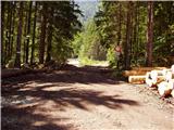
Over the border crossing Rateče we drive towards Trbiž / Tarvisio. Only a few meters before the mentioned town (immediately after the longer underpass under the railway track) the road branches off sharply to the left towards the village Koprivnik / Ortigara and Male Rovte / Rutte piccolo. We head onto this road which through Male Rovte brings us to a crossroad above the mentioned village. We continue left (right Pliči / Plezzut) on even a little narrower road which lies higher up, and after a short descent brings us to the next crossroad, where near it we park (we park in a way that we don't hinder forestry work).
Access is also possible over the border crossing Predel (in the settlement Pliči / Plezzut we turn right, and then we join the road from the above description).
Route description:
From the crossroad, we go right, on the forest road closed to traffic in the direction of "Bivio, La Portella and Cave del Predil". The road which barely ascends, after approximately 15 minutes of walking brings us to a crossroad, where the path number 511 branches off to the right (ascent possible also on this path), and we continue straight on the "main" road which a little further brings us out of the forest on extensive scree fields of the Remšendol valley.
Over the scree fields we continue by the right side (here blazes are less frequent because of torrent deposits), then we notice the blazes which direct us slightly right on at first gentle mountain path (path number 518).
The path ahead ascends gently parallel with the valley, then after crossing a gully passes into a forest belt. A short steep ascent follows through the forest, then the path brings us to the foot of steep cliffs (danger of falling stones), where we step on an indistinct and exposed ledge along which we continue the ascent. A gentle traverse ascent on occasionally exposed slopes follows (in wet great risk of slipping), then the path brings us to a mighty gully. We cross the mentioned gully (at high water level the passage is impossible!) and then on the other side we start very steeply ascending along the gully upwards (great risk of slipping). Higher the steepness eases and the path, which all the time runs through the forest, after approximately 2 hours of walking from the starting point brings us to the hut or bivouac Rifugio Cinque Punte, from which a nice view opens up on the walls of Rabeljske špice.
From the hut we walk to the other side of the clearing, then continue left into the forest on the marked path (number 520), which starts ascending at the foot of Rabeljske špice. The path soon levels out, then continues traversing towards the saddle Sella della Malga.
The traverse section of the path offers a nice view on Poldnik (2063 m), Mangart (2678 m) and other peaks which surround the Remšendol valley. After a short traverse we reach the mentioned saddle, from which the first view opens towards the Viševa group (for the view we must stray a little from the marked path).
On the saddle the path turns left and gradually starts ascending steeper and steeper. Higher the path gradually passes from the forest to more and more panoramic slopes grown with dwarf pines. A little further we step on the main ridge, where the path turns slightly right, descends for a few steps, then brings us below the summit, to which only a short steep ascent separates us.
Starting point - Rifugio Cinque Punte 2:00, Rifugio Cinque Punte - peak 1:00.

Photos:
 1
1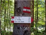 2
2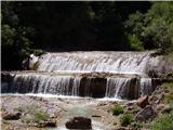 3
3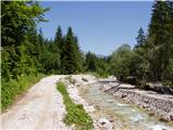 4
4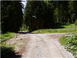 5
5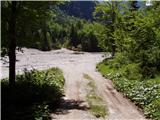 6
6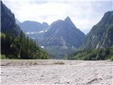 7
7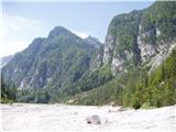 8
8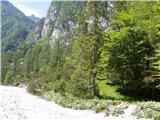 9
9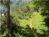 10
10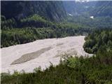 11
11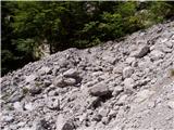 12
12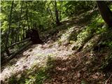 13
13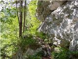 14
14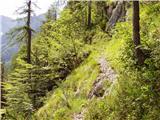 15
15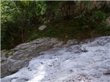 16
16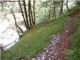 17
17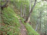 18
18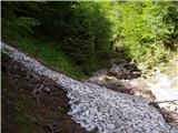 19
19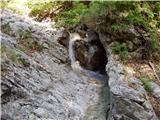 20
20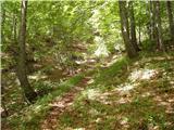 21
21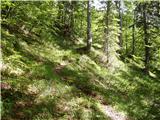 22
22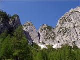 23
23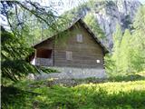 24
24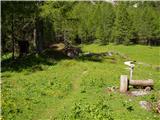 25
25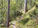 26
26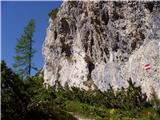 27
27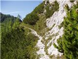 28
28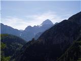 29
29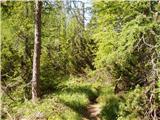 30
30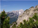 31
31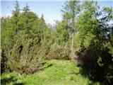 32
32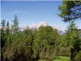 33
33 34
34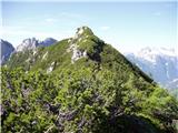 35
35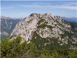 36
36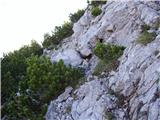 37
37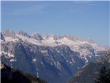 38
38 39
39
Discussion about the trip Remšendol - Šober / Monte Sciober Grande (via 518)
|
| cybee27. 05. 2023 22:50:30 |
Today I did a circular route, up via 511 and down via 518. Excellent hike. I would like to warn that path 518 in the lower section is in very poor condition in some parts, uncleared and worst of all, some sections of the path are eroded or have already slid into the abyss, which is 10 meters or more in places. Interestingly, 511 is in good condition, as is the upper part of 518. You definitely need to be very careful. The markers are still quite visible, but the path itself is dangerous, especially the last 300-400m (visible in photo no. 6).
|
|
|
|
| darinka411. 10. 2023 07:20:08 |
When you're in these parts for the first time, everything is interesting. It was a full day's tour indeed. Which we extended to both Grintovci, next to Šober, where you turn to the summit casually. If I think about it right, I wasn't quite sure we'd reach Grintavec through that rocky rugged terrain. If we had a little more time, we would have climbed Vršič too, which was on the opposite side of the Grintavci. But we really didn't meet anyone. We admired beautiful pools on the ascent and descent. We managed to hike it circularly. Nice views from the ridge, where Rajbelj is nicely visible. At the bivouac, you can refill water.
|
|
|
|
| keti120. 03. 2024 10:13:41 |
And does anyone know the condition of path 520 from Remšendol to Rifugio Cinque Punte as an alternative to path 518 if this one is in quite poor condition?
|
|
|
|
| turbo21. 03. 2024 16:04:26 |
|
|
|
|
| darinka421. 03. 2024 17:21:57 |
Last year we walked this path. Just as Bojan wrote. It's without special features. There's water before the bivouac. The path further to both Grintovci where we went is also clearly visible. Panoramic. It doesn't get many visitors anyway. On the descent where it was washed away they installed a rope to help yourself. In any case we had no problems.
|
|
|
|
| keti123. 03. 2024 21:53:55 |
Thanks to both for the information. Best
|
|
|
|
| mihaoblak20. 07. 2024 08:57:10 |
On 18.7.2024, my wife and I went up via 511, down via 518 to Male Rovte (Rutte Piccolo). On 511, they changed the route in the section below Mala Ruša - it first goes under the wall and only then crosses the scree. At one crumbly spot there is a rope that helps a lot. On 518 there is quite a bit of fallen trees, which don't obstruct the path otherwise, except at Fratta Valfrassino, where because of it the path completely disappears and has to be found on the western side of the clearing. Lower down at around 1000 meters, they were doing bark beetle control, and the newly cleared area is very difficult to pass. It can apparently be bypassed on the southeastern side through the forest, but we didn't find the path and stumbled through the blackberries.
|
|
|
To post a comment you must log in:
If you do not yet have a username, you must first
register.