Starting point: Renke (254 m)
| Latitude/Longitude: | 46,09300°N 14,95160°E |
| |
Walking time: 1 h 30 min
Difficulty: easy marked way
Elevation gain: 602 m
Elevation difference along the route: 602 m
Map: Posavsko hribovje - zahodni del 1:50000
Recommended equipment (summer):
Recommended equipment (winter): crampons
Views: 17.583
 | 2 people like this post |
Access to starting point:
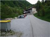
A) From Zagorje ob Savi we drive on the main road towards Litija approximately 5 km, where we notice a signpost for the village Renke. There we turn left and after a few meters we are on the parking lot.
B) From Litija we drive approximately 10 km on the main road towards Zagorje to the signpost for Renke. We turn right and we are already on the parking lot.
Route description:
From the parking lot, we start walking on an asphalt road, cross the bridge over the stream Šumnik and continue through the village Renke. After a few minutes of walking on the road, a footpath branches off to the right into the forest. On this footpath, which is pretty steep in places and offers some views on the valley of the river Sava, we continue for about 25 minutes, then the footpath gradually changes into a wider forest road. After a few minutes of walking on this forest road, we soon arrive in the village Ravne. We continue through the village, at the last houses in the village we turn right onto a somewhat rougher macadam road, then after a few steps left. We follow this rougher path for a few more steps, after which follows a slightly poorly marked part of the path. The path, which is getting worse, turns left at this spot, while straight ahead a short valley opens up, through which we continue. At the end of this valley we again notice the blazes, which lead us back onto a narrower forest footpath. From here to the top, there is only an occasionally quite steep ascent on a well-marked footpath, which is quite slippery in wet weather.

Photos:
 1
1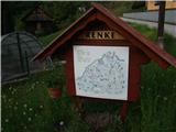 2
2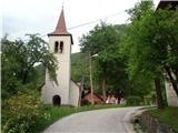 3
3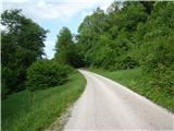 4
4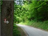 5
5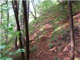 6
6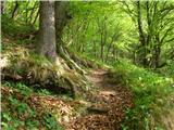 7
7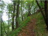 8
8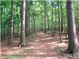 9
9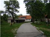 10
10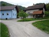 11
11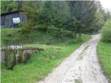 12
12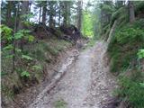 13
13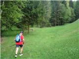 14
14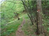 15
15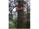 16
16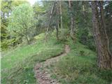 17
17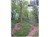 18
18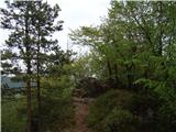 19
19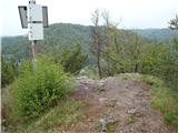 20
20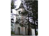 21
21 22
22
Discussion about the trip Renke - Ostrež
|
| Lj4. 05. 2011 |
Last year we walked a very nice path from chapel to chapel, part of which is also the ascent to Ostrež: Polšnik-Preveg-Ostrež-Stranski vrh-Glinjek-Polšnik. The trip is suitable for children, there are many curiosities along the way e.g. legends written at each chapel.
|
|
|
|
| zlatan4. 05. 2011 |
My first path description  I hope it's understandable enough I hope it's understandable enough
|
|
|
|
| Enka5. 05. 2011 |
Recently I was looking for data on the Path from chapel to chapel. I'm interested in how much walking is on the road and how much on footpaths etc.?
|
|
|
|
| Boštjan MK5. 05. 2011 |
Diligent hike organizer Mateja reports:
Approximately 1/3 of the path is on road, the rest on forest paths. More information is on our website: www.polsnik.si
This year we invited Slovenian borderlanders as guests: choir from Italy, folk dancers from Hungary and vocal group from Austria. They will bring many interesting things from their areas with them.
At the end Zasavci will play. A new Polšnik brochure will also be published (approx. 8 pages presenting the place, farmers, entrepreneurs, hike and farmers' day...) Still in production ...
I hope the new attraction will also be the oven on the windy pedestal at Glinjek (under construction)
|
|
|
|
| Lj5. 05. 2011 |
We did this trail outside the official hike and it is very well marked, only at two places we were a bit unsure since it was our first time in these areas: below Stranski vrh, when the asphalt road splits into 2 directions with no sign, you need to go right, and when we reached Lovski dom it wasn't clear which way the center of Polšnik is, where we left the car. Otherwise really beautiful places that we don't know enough about.
|
|
|
|
| Enka6. 05. 2011 |
Thanks everyone for the info. I already found the Polšnik website before of course thanks anyway. A trail map like the one used as background on the website would be very welcome (if I may suggest :jezik!
Lj - so where exactly to turn when you reach the hunting hut? Because we would also go solo variant.
|
|
|
|
| Lj6. 05. 2011 |
We descended the forest path to the road junction in front of the hunting hut: two asphalt roads go right one left and another cart track left. You need to go on the cart track left past the hunting hut. Probably the asphalt road left also reaches the starting point but via a longer route. We used the map Posavsko hribovje-eastern part (Menina-Ostrež-Kum) but this path is not drawn in you get some orientation on path sections along roads. On ZS I'm sending you a link to my album from this trail.
Good luck and best regards Ljubica
|
|
|
|
| Boštjan MK7. 05. 2011 |
As "lj" already said, the nearest is the first gravel road that descends on the left side of the hunting hut (viewed from the intersection towards the hut) to the starting point at Polšnik, which is another 10 minutes walk. Of course, you can also come via the asphalt road (far left towards the hut), which bypasses the Repovž farm (Pr Končar) and at the intersection choose the right road (total about 15 minutes to the starting point). Good luck!
|
|
|
|
| Rudi2618. 05. 2011 |
Does anyone know where the stamp for the Zasavska planinska pot is, is it at the top or somewhere else?
|
|
|
|
| zlatan2. 01. 2012 |
ZPP stamp is in the village Preveg (house number 3) below Ostrež summit.
|
|
|
|
| navdušena7. 04. 2019 |
The described parking is blocked. Car can be parked on the main road opposite the Renke turnoff.
|
|
|
|
| AndrejK21. 05. 2019 |
Hi, please a tip for access to Ostrež from Podkum village. Thanks
|
|
|
|
| janezz13. 04. 2020 |
We were looking for a suitable path from the other side, as described, and we drove to Preveg, where there is a path from church to church. If you make a circular route, it's quite a pleasant trip, especially since we were with two children (3 and 5). If going from Polšnik, we walked to the starting point along a non-traffic road.
|
|
|
|
| fpetel114. 04. 2020 |
This year I already led the second trip to this Ostrež. We went on 29.2., when the Corona virus was not yet monitored in Slovenia. We went from the village Renke to the village Ravne, to the summit and on the other side first to Preveg and through the forest back towards the village.
Nice half-day trip, which with breaks takes four hours.
Years ago we continued the path from Preveg to Podkum and to the summit of Kum.
All paths are marked, but this one between Podkum and Preveg is the worst marked. The first part goes more across the meadow, later along the road.
|
|
|
|
| Sandi in Tanja7. 12. 2025 19:45:16 |
The parking lot is still fenced off, park at the parking lot opposite the entrance to Renke. The signpost in Renke with its 3 hours is a bit inflated. Otherwise, the trail is well marked along the entire route. We did the last part of the ascent directly along the ridge, on the descent past the church we used the lower path, which we continued past the village. The stamp is located at the church entrance. Photos are at https://medves.si/potepanja/2025-12-07-Ostrez/index.htm
|
|
|
|
| DVas14. 01. 2026 09:09:29 |
|
|
|
To post a comment you must log in:
If you do not yet have a username, you must first
register.