Rifugio Dibona - Tofana di Rozes (via Rifugio Giussani)
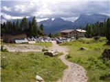
Starting point: Rifugio Dibona (2083 m)
| Latitude/Longitude: | 46,53260°N 12,07030°E |
| |
Route name: via Rifugio Giussani
Walking time: 4 h
Difficulty: difficult marked way
Elevation gain: 1142 m
Elevation difference along the route: 1142 m
Map: Tabacco 03 1:25.000
Recommended equipment (summer): helmet
Recommended equipment (winter): helmet, ice axe, crampons
Views: 28.656
 | 3 people like this post |
Access to starting point:
First, we drive to Cortina d'Ampezzo (to get here, possible via the border crossing Rateče or Predel to Trbiž / Tarvisio and then on the highway in the direction of Videm / Udine to the exit Tolmezzo. From Tolmezzo we follow the road in the direction of the village Ampezzo and the mountain pass Passo della Mauria. The road then descends and brings us to a crossroads, where we continue left (possible also right) in the direction of Cortina d'Ampezzo. At all next crossroads, we follow the signs for Cortina d'Ampezzo. Or from the Primorska side, where we drive on the highway in the direction of Trst / Trieste. Further, we drive on the Italian highway in the direction of Padova, but only to the highway junction, where we continue in the direction of Veneto and Belluno. Near Belluno the highway ends, and at the next crossroads we continue in the direction of Cortina d'Ampezzo and then follow the signs for the alpine pass Passo di Falzarego. We then follow this ascending road to the spot where the road to the mountain hut rifugio Dibona branches off to the right (the turn-off is at an altitude of approx. 1700 meters). The considerably rough and initially asphalt road brings us higher to a crossroads, where we continue on the left lower road (right: mountain hut Duca d'Aosta) and follow it to the parking lot for the mountain hut Dibona.
Route description:
From the parking lot, we continue on a macadam road past a gate. We follow this road to a crossroads with signposts, where we go right on a wide mule track following the signs »Rif. Camillo Giussani«. The wide path then slowly ascends and in the left bend the path from the mountain hut Rifugio Pomedes joins us, a little later also from the left path 404, which crosses the slopes below the south wall of Tofana di Rozes. The mule track then continues to ascend on the increasingly steep slope between Tofana di Rozes and Tofana di Mezzo. Soon we come to the abandoned mountain hut Cantore. A short ascent follows alongside the cargo cableway and we are already at the mountain hut Rifugio Giussani.
From the mountain hut, we continue towards the west and after a short ascent over scree the path from the peak Tre Dita (three fingers) joins from the right. At the junction, we continue left upwards and on a somewhat steeper path we begin to ascend towards the ridge. The blazes on this part of the path are very rare and strongly faded, numerous cairns assist us. During the ascent towards the ridge, some caution is also needed because there is quite a lot of scree on the path. When we reach the ridge, the climbing path up the west wall of Tofana di Rozes also joins from the right. There follows an ascent along the summit ridge and soon we reach the very panoramic summit.

Photos:
 1
1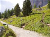 2
2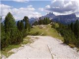 3
3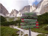 4
4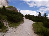 5
5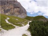 6
6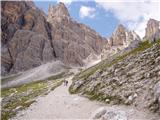 7
7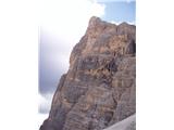 8
8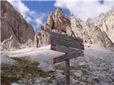 9
9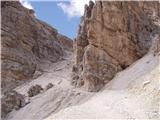 10
10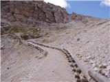 11
11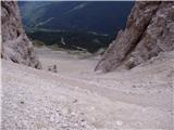 12
12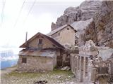 13
13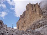 14
14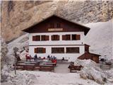 15
15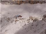 16
16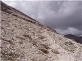 17
17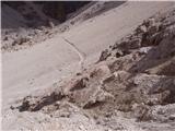 18
18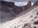 19
19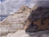 20
20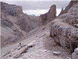 21
21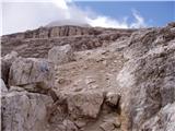 22
22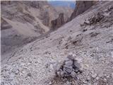 23
23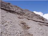 24
24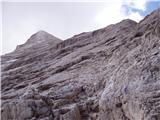 25
25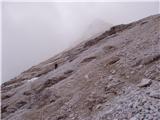 26
26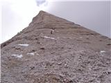 27
27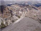 28
28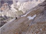 29
29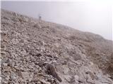 30
30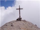 31
31
Discussion about the trip Rifugio Dibona - Tofana di Rozes (via Rifugio Giussani)
|
| proplayer1119. 08. 2009 |
This route is probably difficult only because of the steep ascent and scree. Am I right?
|
|
|
|
| ben9. 08. 2009 |
You're right, and it can be particularly unpleasant on the descent (full of scree on smooth slabs)!!
LP B
|
|
|
|
| guba20. 07. 2011 |
isn't it demanding because of fitness 
|
|
|
|
| ben20. 07. 2011 |
I don't know, the elevation gain isn't much, I only descended here. There's another hut in between though, so it shouldn't be too strenuous!!!!
Best, B
|
|
|
|
| mirank21. 07. 2011 |
Rifugio A. Dibona is at over 2000m, so elevation gain is just over 1100m. We did the path in descent in 1.5h and in that time there's still a small detour to the hut (2x100m path) to Rifugio Giussani, which is already mentioned. No other huts in between!!! Otherwise, in my opinion, the ascent path is not really demanding with normal fitness, of course. Good luck
|
|
|
|
| serznoz29. 09. 2014 |
Did the path on Friday. Although the mountain is impressive and seemingly inaccessible from some directions, the access is much easier than to our much more crowded mountains. No fixed ropes on the path, most of it doable with poles. But the scree is quite unpleasant, the whole mountain is strewn with it, caution needed due to slippage. Many paths, marked path poorly traceable, but can't miss it. Might need to find a passage over a rocky step. On Friday there were quite a few ice falls and cascades across the path to avoid. Otherwise the mountain is worth the views.
|
|
|
|
| veja530. 06. 2019 |
Does anyone have info on snow and condition on the normal path and on Lipella?
What are the difficulties on Lipella from Casteletta to the exit at Tre Dita? Are there any steps on the ascents or just pure arm strength?
Best regards. Venčeslav.
|
|
|
|
| don kihott30. 06. 2019 |
I think you'll need general fitness the most on Lipella...
|
|
|
|
| janezs732. 07. 2019 |
The last harder section below the exit to the summit ridge is a bit annoying slab with only a vertical fixed cable, especially if you're already tired and running out of stamina (as don kihott wrote - stamina is the key to victory  )... )...
|
|
|
|
| veja510. 08. 2019 |
Yesterday I stood on the pink Tofana and looked into the fog, valley, Giussani, and more, no need to list.
Up and down via normale.
To Giussani mulatiera, then alternately scree and ledges, hanging downwards, covered with scree.
If my wife wasn't with me, I would...
Road to Dibona first asphalt, last part bad gravel. Car in first gear.
At the mountain top quite crowded, normal route hikers and via ferrata climbers together. Nice boots, air already quite thin, you feel it.
Best regards, Venčeslav.
|
|
|
|
| pohodnik3336. 09. 2023 21:11:00 |
I descended this path to the east (Rifugio Guissani).
Many of us chose this variant (not over Tre Dita). This path goes over slightly inclined ledges and there's a lot of scree, no iron here.
It can be unpleasant and dangerous for slipping, because there are no pegs, cables. If the ledges were slightly wet, I advise against this path, probably better over Tre Dita.
|
|
|
|
| felix31. 03. 2024 08:14:34 |
Did anyone drive to Dibona last year, is the road any better maintained than in previous years?
|
|
|
|
| Pastirica31. 03. 2024 16:19:49 |
I don't know what it was like before, but last year on the first of October I got up there without any problem (Panda). On the return, the parking lot was packed full of all sorts of cars.
|
|
|
To post a comment you must log in:
If you do not yet have a username, you must first
register.