Rifugio Gardeccia - Catinaccio d'Antermoia / Kesselkogel
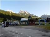
Starting point: Rifugio Gardeccia (1950 m)
| Latitude/Longitude: | 46,43832°N 11,69319°E |
| |
Walking time: 3 h 30 min
Difficulty: very difficult marked way
Via ferrata: B
Elevation gain: 1054 m
Elevation difference along the route: 1060 m
Map: Tabacco 06 1:25.000
Recommended equipment (summer): helmet, self belay set
Recommended equipment (winter): helmet, self belay set, ice axe, crampons
Views: 5.370
 | 3 people like this post |
Access to starting point:
Access from Gorenjska: Through the Karawanks Tunnel, we drive to Austria, and then we continue driving towards Spittal and further towards Lienz (the highway ends a little after Spittal). Further, we drive on a relatively nice and wide road through the Drau Valley, which brings us to Italy. The road further leads past Dobbiaco / Toblach and Brunico / Bruneck. Just a little after the last-mentioned town, past which a bypass leads, we turn left into the Val Badia valley. Further, we drive through the mentioned valley past the places La Villa and Corvara. Next follows an ascent over the passes Passo Campolongo and Passo Pordoi. From the pass Passo Pordoi, we then descend to the west side into the Val di Fassa valley. We continue to the place Pera di Fassa where we park on a large parking lot at the bottom station of the chairlift »Pera Vajolet 1«.
From here, there is organized transport by minibus to the hut Rifugio Gardeccia. The price of the return ticket is 10€ (July 2015). The minibus starts at 7:00, the last drive from the hut Gardeccia is at 19:00. The road to the hut is otherwise closed to public traffic.
From the Primorska side: From Nova Gorica, we drive to Italy and further on the highway towards Venice / Venezia. Near the town Portogruaro, we leave the highway towards Venice and continue right on the highway towards Pordenone. At the next highway junction near Conegliano, we continue right towards Belluno. We follow the highway to the exit for Belluno. When we leave the highway, we come to a larger roundabout, which we leave at the exit for Belluno and the place Feltre. In the smaller roundabout in Belluno, we then continue right towards Agordo. We follow this road all the way to Moena in the Val di Fassa valley. In Moena, we then continue right towards Canazei, but only to Pera di Fassa where we park on a large parking lot at the bottom station of the chairlift »Pera Vajolet 1«.
From here, there is organized transport by minibus to the hut Rifugio Gardeccia. The price of the return ticket is 10€ (July 2015). The minibus starts at 7:00, the last drive from the hut Gardeccia is at 19:00. The road to the hut is otherwise closed to public traffic.
Route description:
From the hut Rifugio Gardeccia we head onto the macadam road towards the hut Vajolet. The road first leads past the hut Rifugio Stella Alpina and brings us into a thin forest. Here the road ascends slightly, the thin forest quickly ends, and a view opens towards the hut Rifugio Preuss, which is clearly visible atop the cliff. Near the mentioned hut is also located the hut Rifugio Vajolet. The panoramic road then becomes flatter for a while, then turns left below the slopes of the peak Cima Catinaccio and begins to ascend somewhat more steeply. The road then ascends all the way to the hut Rifugio Vajolet from where there is a very nice view towards the towers Torri del Vajolet.
A little after the hut, the path Sentiero Don Guido branches off to the right towards the peak Cima Scalieret, while we continue on the relatively wide path towards the hut Rifugio Passo Principe. The path soon brings us to another marked junction. This time, the path branches off to the left upwards towards the huts Rifugio Re Alberto and Rifugio Passo Santner. We continue on the fairly flat path 584 towards the hut Rifugio Passo Principe. The path here constantly runs north through the Val di Vajolet valley, and an increasingly beautiful view begins to open towards the highest peak in the mountain group Catinaccio d'Antermoia (Kesselkogel). At the end of the valley, the slope becomes slightly steeper, but the ascent is not difficult. On the wide path, we soon reach the Passo Principe hut, located on the eponymous saddle on the western side of the peak Catinaccio d'Antermoia.
From the hut, we continue following the signs »585 Kesslkogel«. The path from the hut, where there is a junction, ascends over scree towards the western wall of the mountain. On the scree, the path is marked with large red arrows. As we approach the wall, the path turns left and leads us along a ledge where there is a fairly low passage. The path then turns right and ascends more steeply through the gully. On this section, the path is not yet secured, so more caution is needed. The path soon brings us to the start of the secured section. Here we ascend gently for a while along the ledge on the south side of the mountain. In between, we also descend slightly on a short ladder. The path then turns left and begins to ascend somewhat more steeply along the steel cable. Higher up, the path takes us to the west side of the mountain where we cross the slope along the ledge. Here in early summer, there may still be snow on the path. The ledge then turns into a gully along which we ascend for a while. Further on, the path mostly ascends along the steel cable; the ascent is not overly demanding and is comparable to secured paths in the Slovenian mountains. In the final section, the path brings us onto the ridge along which we soon reach the summit. When walking along the ridge, more caution is needed as the ridge in the final part is not secured.
We can descend via the ascent path or continue along the secured path to the eastern side and then return via the Passo di Antermoia saddle towards the Passo Principe hut.

Photos:
 1
1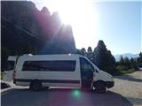 2
2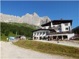 3
3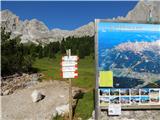 4
4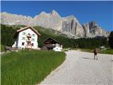 5
5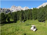 6
6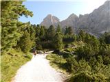 7
7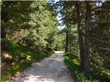 8
8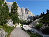 9
9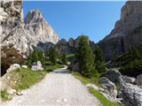 10
10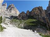 11
11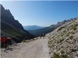 12
12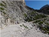 13
13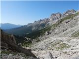 14
14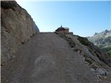 15
15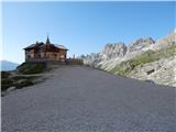 16
16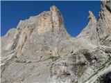 17
17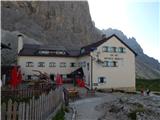 18
18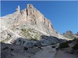 19
19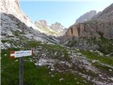 20
20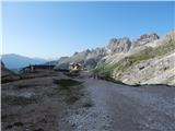 21
21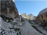 22
22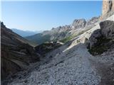 23
23 24
24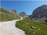 25
25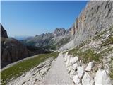 26
26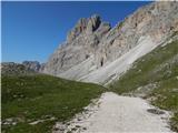 27
27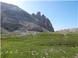 28
28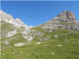 29
29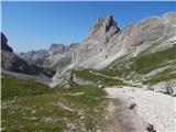 30
30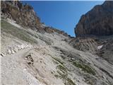 31
31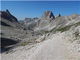 32
32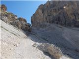 33
33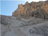 34
34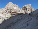 35
35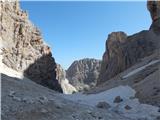 36
36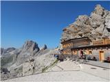 37
37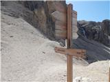 38
38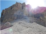 39
39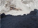 40
40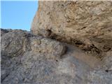 41
41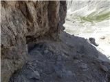 42
42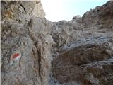 43
43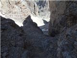 44
44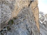 45
45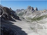 46
46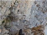 47
47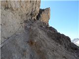 48
48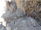 49
49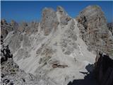 50
50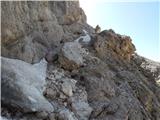 51
51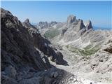 52
52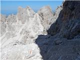 53
53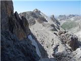 54
54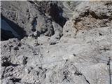 55
55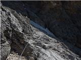 56
56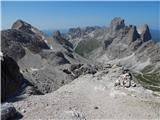 57
57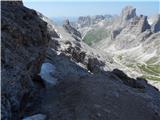 58
58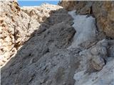 59
59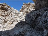 60
60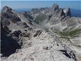 61
61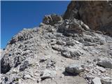 62
62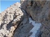 63
63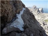 64
64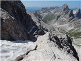 65
65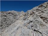 66
66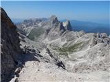 67
67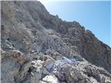 68
68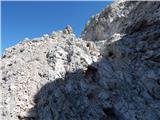 69
69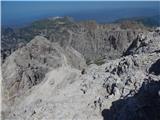 70
70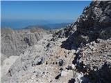 71
71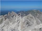 72
72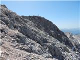 73
73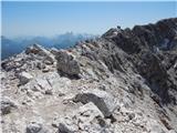 74
74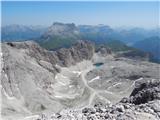 75
75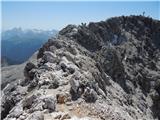 76
76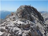 77
77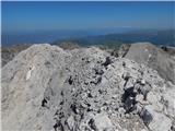 78
78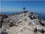 79
79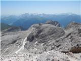 80
80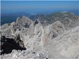 81
81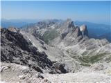 82
82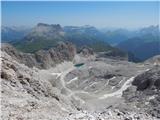 83
83
Discussion about the trip Rifugio Gardeccia - Catinaccio d'Antermoia / Kesselkogel
|
| Paglia6. 09. 2020 |
Super!
Yesterday we made the ascent to this beautiful mountain in the heart of the Dolomites.
On Friday afternoon we set off from home and in the town of Pera di Fassa you have to drive along the main road a bit further past the cable car station lying down to the right until you notice a small sign on your left side via Gardeccia and after a few kilometers on this road we stop at the end of the hamlet Muncion, where we park by the road. Then on foot along the long asphalt road to the Gardeccia hut where we arrive at the hut already in the dark. The pleasant large hut offers double rooms for 40 eur per person with a rich breakfast (without breakfast 36 eur). Discount with A membership card unfortunately does not apply road to the Gardeccia hut where we arrive at the hut already in the dark. The pleasant large hut offers double rooms for 40 eur per person with a rich breakfast (without breakfast 36 eur). Discount with A membership card unfortunately does not apply
In the morning after breakfast on a beautiful day we continue past the Vajolet hut and higher we arrive at the last hut before the ascent to the summit, Rifugio Passo Principe, which picturesquely lies in the rocks.
Although we had harnesses with us, I think they are not necessary for slightly more trained hikers, depending on the individual, although almost all locals use them.
To make it easier for you to imagine both the ascent and the descent on the other side, the difficulty can be compared to our secured path e.g. from Češka koča to Kočna.
So on the left path to the summit a beautiful newly equipped ferrata, just before the summit a narrow ridge, at the summit unique, wonderful views.
Descent continues further from the start a shorter part along the summit ridge then the secured path descends steeply down, this part is at times more exposed than the ascent, but the technical difficulty does not exceed the ascent difficulty. When we arrive almost to the bottom the path branches sharply to the right and unfortunately we have to climb up scree for good twenty minutes to the Antermoia saddle, from there descend again to the Passo Principe hut.
From there back past the Vajolet hut, where we take another great break in the unique environment, down to Gardeccia and unfortunately (no other way) along the asphalt to the car.
The first day we used just over an hour of walking, the second day with breaks good 8 hours.
Try it, you won't regret it, there are many huts in this area, yesterday they were all still open for overnight stays, until when I didn't inquire, info on the internet.
If we went again to better distribute the walking, we would rather sleep in Vajolet hut or even in Passo Principe, if anyone has any questions, I will gladly answer.
|
|
|
|
| Borut129. 07. 2021 21:35:43 |
The minibus from the lower cable car station (as written in the access description to the starting point) no longer runs for several years. Instead of this transport, you can buy a ticket for the cable car to the second station (return ticket for an adult costs 13 Eur). The last ride down the valley is at 18:00. From the second cable car station to the Gardeccia hut there is still 40 minutes of walking on a wide and gentle path.
|
|
|
To post a comment you must log in:
If you do not yet have a username, you must first
register.