Bele vode - Viš/Jof Fuart (Sentiero del Centenario)
Starting point: Bele vode (980 m)
| Latitude/Longitude: | 46,40950°N 13,53600°E |
| |
Route name: Sentiero del Centenario
Walking time: 6 h
Difficulty: very difficult marked way
Via ferrata: B/C
Elevation gain: 1686 m
Elevation difference along the route: 1900 m
Map: Julijske Alpe - zahodni del 1:50.000
Recommended equipment (summer): helmet, self belay set, lamp
Recommended equipment (winter): helmet, self belay set, ice axe, crampons, lamp
Views: 36.887
 | 1 person like this post |
Access to starting point:
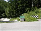
From Kranjska Gora over the border crossing Rateče we drive to Trbiž / Tarvisio. In Trbiž we continue left in the direction of Bovec and we follow the road to the intersection near Rabeljsko jezero. Here we continue right in the direction of Nevejski preval / Sella Nevea. We follow this road, which is mostly ascending, to the bridge, where in the left bend the road crosses the stream Bele vode / Rio Bianco. On the left side of the road, we will notice a few smaller parking spots.
From Bovec, we drive to the border crossing Predel, from which we descend to the Italian side. Just a little after Rabeljsko jezero we come to the intersection, where we continue left in the direction of Nevejski preval / Sella Nevea. Further, follow the above description.
Route description:
From the signposts at the beginning of the path (before the bridge on the right side of the road) we continue through the forest on the right side of the stream Rio Bianco along which we slightly ascend for quite some time. The valley of Bele vode (Ital. Riobianco) also got its name from the stream. The path then turns to the left and crosses smaller streams a few times. Later, the path turns a little to the right again and a shorter ascent in hairpins follows to the abandoned hut Brunner, where there is no view because of the forest. At the hut, where there is also a junction, we continue straight on path 625 in the direction of bivouac Gorizia. The path soon comes out of the forest and ascends along the stream through dwarf pines. Later the path turns to the left and brings us to a junction. We continue on the left path towards bivouac Gorizia, to the right the path towards the notch Bele vode (Ital. Forca di Rio Bianco) branches off. The dwarf pines soon end, and the path starts to ascend a little more steeply. When the path flattens a little again, the sign on the rock directs us left towards the bivouac, to which we have about 50 meters, to the right a direct path leads towards Krniška škrbina (Ital. Forcella del Vallone).
From the bivouac we continue south and start to ascend quite steeply on the scree slope towards the notch Alta di Rio Bianco (2150 m). On the notch the path turns right and ascends for a short time on slightly scree terrain, then brings us to steel cables along which we ascend quite steeply. The hardest part of the path follows, where we must descend vertically into a narrow notch. On this section self-belaying is highly recommended. From the notch we then climb up the vertical ladder, then slightly gentler slopes bring us to the narrow ridge. The path along the ridge is secured with a steel cable. Later the path turns left and a short descent on scree terrain follows, then along the steel cable to the entrance to the tunnel. On the path through the tunnel there are also bends and descents on ladders, so the use of a headlamp is mandatory. When we exit the tunnel a short crossing of the steep slope follows to Krniška škrbina, where an easier path from bivouac Gorizia joins from the right. From the notch a descent on scree follows and then on increasingly grassy terrain, which brings us to a junction. We head right onto path 627, left the path leads towards hut Corsi, to which there is about 15 minutes of descent. After a short ascent we come again to a junction, where we go left (direction Jof Fuart), right path 627 leads towards Trbiška škrbinica (Forcella di Riofreddo). The path then turns slightly left and brings us to the start of a somewhat more difficult section. Here the path turns right upwards and some easy climbing on rock is also required. The path then turns slightly right and brings us to another somewhat harder section. Here the path turns left upwards and starts ascending along the steel cable. A somewhat low passage through a window follows and then ascent along the steel cable again. The path then brings us to a junction, where path Anita Goitan joins from the right from precipitous ledges. After a short ascent we come again to a junction where we go right, left path Anita Goitan branches off. A moderately steep ascent follows on rocky and somewhat scree terrain. Just below the summit the northeastern path Gola Nordest joins from the right. From here only a short ascent to the very panoramic summit follows.

Along the route: Rifugio Brunner (1432m),
Bivouac Gorizia (1950m), Alta di Rio Bianco (2150m), Krniška škrbina/Forcella del Vallone (2180m)
Photos:
 1
1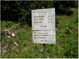 2
2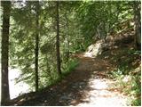 3
3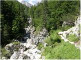 4
4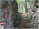 5
5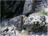 6
6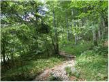 7
7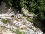 8
8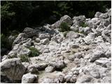 9
9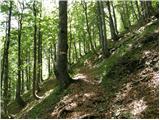 10
10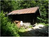 11
11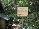 12
12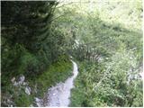 13
13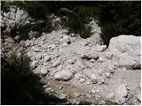 14
14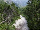 15
15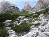 16
16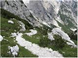 17
17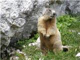 18
18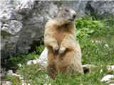 19
19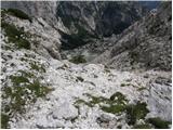 20
20 21
21 22
22 23
23 24
24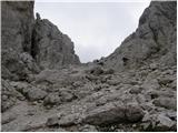 25
25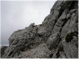 26
26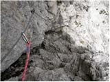 27
27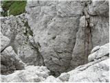 28
28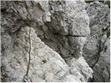 29
29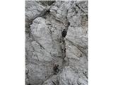 30
30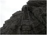 31
31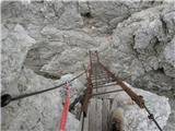 32
32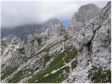 33
33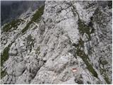 34
34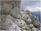 35
35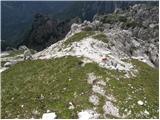 36
36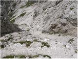 37
37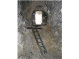 38
38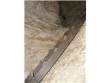 39
39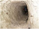 40
40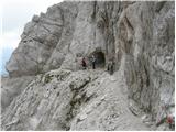 41
41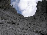 42
42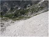 43
43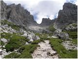 44
44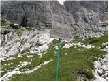 45
45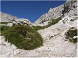 46
46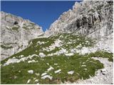 47
47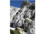 48
48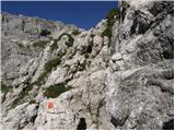 49
49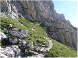 50
50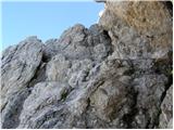 51
51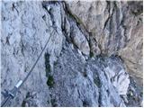 52
52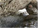 53
53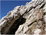 54
54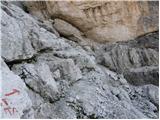 55
55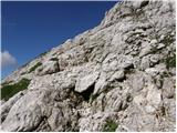 56
56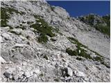 57
57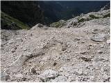 58
58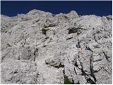 59
59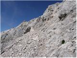 60
60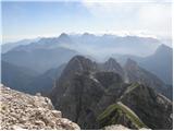 61
61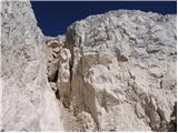 62
62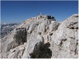 63
63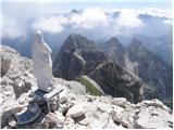 64
64 65
65
Discussion about the trip Bele vode - Viš/Jof Fuart (Sentiero del Centenario)
|
| barjus17. 07. 2011 |
The path from the bivouac is very poorly marked, or not at all in places. From the bivouac you make quite a big detour according to the upper description, because the path is already quite long. It is true that at least something is happening here, but a headlamp is necessary, otherwise you can only turn back. When you get above Rifugio Corsi, it's again a lottery to hit the right path, especially if you don't know which summit is the right one. It is true that we have a tongue and ask, like we did and after a quite long summit part reached the top. But we didn't really need the safety equipment.
|
|
|
|
| toneh218. 09. 2012 |
Centenary Path - the path from the bivouac to the notch Alta di Rio Bianco (2150m) is not marked at all. Even cairns are missing (!), only occasional shoe prints confirm that it is frequented. At the notch you spot the first marking on solid rock, from there on everything is fine - markings and protections.
|
|
|
|
| mary20. 09. 2012 |
Hi! Interested in timing for the route to Viš past Krniška škrbina to Rif. Corsi hut, then to Trbiška Škrbinica on Anita Goitan path to summit. Descent to Škrbina zadnje Špranje past Koštrunovi spici, to Škrbina prednje Špranje (where A.G. path ends) then either to Rif. Corsi hut and down ascent route via Krniška škrbina or to Viška Planina then road back to Bele vode start. Feasible in one day at fast pace  ? Thanks to all experts! Best, Mary ? Thanks to all experts! Best, Mary
|
|
|
|
| IgorZlodej20. 09. 2012 |
Feasible but really very, very fast pace and dry conditions. From Krniška škrbina no need down to Corsija, crossing possible a bit higher under walls. Return over Krniška škrbina, hmm, I'd prefer from Prednje špranje straight down to Viška planina, of course if car at parking below, otherwise from Prednje Špranje under Kapna stena to Corsi and path through gullies past Viška glavica to start at Beli potok end, road difference just 500m.
|
|
|
|
| MarkoKomar3. 08. 2013 |
Hi,
Does anyone have any recent info on the described path. What are experiences with sleeping at Rifugio Corsi or Bivacco Gorizia in August (stay from Sunday to Monday). Thanks for reply. Best, Marko
|
|
|
|
| sabina.76. 08. 2013 |
We two were in Bivacco Gorizia from Saturday to Monday. Bivouac OK, no one there except us. During the day occasionally someone passes by, otherwise we had company of chamois, ibex and marmots. There is also some snow, so if you run out of water, you can melt it. Warm during the day, cold in the evening. Best, S
|
|
|
|
| VanSims11. 08. 2014 |
From Bivacco Gorizia you just continue ahead past the large rock towards the notch where on the right we see the plaque marking the entry into Sentiero Centenario. The path is direct and you can't get lost anywhere. It is true that there are no markings and you have to manage on the rocks yourself.
At Corsi there's also no lottery like someone wrote above. Everything is nicely marked and as described above, you just need to be a little attentive to the signs.
|
|
|
|
| Shime26. 05. 2015 |
Hello;
during the summer we plan to hike the path as described above, so I'm interested in impressions from Rof. Corsi as we plan to sleep there. Is knowledge of Italian necessary for communication or can one speak English/Slovenian/Croatian?
Also interested if the water from the spring near the hut is drinkable? The hut's pages say there is a spring, so it would be good to know if the spring is good (in case needed).
Thanks for the info! Best regards
|
|
|
|
| klm26. 05. 2015 |
Shime, one can speak Italian, English or German (Croatian and Slovenian not, since they are not world languages but Serbian is possible too )
Around the house there are plenty of springs, and the water is also drinkable.
If there are any more questions, just ask them.
Best regards
|
|
|
|
| Shime28. 05. 2015 |
Thanks, that makes everything much easier for me, from ordering beer  to booking accommodation (if I were right, I'd learn Serbian to booking accommodation (if I were right, I'd learn Serbian  ). ).
I have one more question: is the discount for members of the Croatian Mountaineering Association recognized in Italy, or do you pay full price?
Once again, thanks for the information!
|
|
|
|
| jedriličar28. 05. 2015 |
Discount on HPS membership cards is recognized only in huts under the management of CAI (club alpino italiano), while in private huts this discount is not recognized (unless you have, say, an OEAV or AAC card and the hut has a sign for discount recognition). When I last slept in Corsio (6 or 7 years ago, not sure) they recognized the discount, and as I see on the Corsio pages http://www.rifugiocorsi.it/ the hut is still under CAI management ...
If you need anything else, ask ... best
|
|
|
|
| Robie16. 07. 2016 |
Exceptional path, extraordinary views and pleasure - no wonder many mountaineers use the word MOUNTAIN PARADISE for this part. Via ferrata short but beautiful and impeccably maintained - protections look new, a bit of caution needed in the tunnel - slippery. Recommend the path past koča Brunner (plenty of water then to Pot stoletnice and return past koča Corsi to the path of the Saxon King, which can be shortened and skip the dangerous part.
|
|
|
|
| lazo122. 07. 2016 |
Please, does anyone know the price of overnight stay at Rifugio Corsi with membership card? Thank you
|
|
|
|
| smatjaz22. 08. 2022 15:43:50 |
WARNING: I warn that at the parking lot of the starting point for bivak Brunner (it's a gravel parking lot, left of the road bridge) and also for Jerebica, cars are being broken into. Be careful so that someone else doesn't have such a bad experience as we did yesterday after returning from Viš.
|
|
|
To post a comment you must log in:
If you do not yet have a username, you must first
register.