Robanov kot - Chapel on Molička planina
Starting point: Robanov kot (650 m)
| Latitude/Longitude: | 46,39480°N 14,70300°E |
| |
Walking time: 3 h 30 min
Difficulty: difficult marked way
Elevation gain: 1130 m
Elevation difference along the route: 1250 m
Map: Kamniške in Savinjske Alpe 1:50.000
Recommended equipment (summer): helmet
Recommended equipment (winter): helmet, ice axe, crampons
Views: 20.371
 | 2 people like this post |
Access to starting point:
Through the mountain pass Volovljek (Kranjski Rak) or from Mozirje we drive to Luče, and then we follow the signs for Solčava and Logarska dolina. When we get to the settlement Robanov Kot, signs for alpine valley Robanov kot point us to the left on a side road, on which we drive to the parking lot near the farm Roban, where we park. We can also park already 500 meters lower, where there is another organized parking lot, but we are not allowed to park on the parking lot of the pension Govc-Vršnik, because consequently there isn't enough space for guests of the pension.
Route description:
If we've parked on the lower parking lot we continue on the road to the parking lot at the farm Roban, and only a few meters ahead of the last parking lot, we get to a crossroad, where we continue straight, on the road, where there is a gate (right - Strelovec).
The road towards Robanova planina then goes into the forest and brings us to a crossing, where we continue straight, further on the road (left - partisan hospital 45 min).
The road then brings us out of the forest onto Robanov travnik, where a nice view opens up on the nearby mountain walls. On the other side of the meadow, the road goes again into the forest and ascends a little steeper. Next follows also a crossing of a grazing fence and soon after that, we come out of the forest onto panoramic Robanova planina.
From the mountain pasture, we continue following the signs »Korošica, Ojstrica« and a wide path already after a few meters brings us into the forest. After a short ascent, the path turns to the left and crosses some riverbeds of torrents. We again ascend through the forest and soon come to a smaller waterfall below the slopes of Molička peč and Velika Zelenica. Here the path turns to the right and with the help of steel cables and some pegs starts ascending on quite steep slopes. Next follows again a short ascent through the forest on a little less steep slopes, and then we come to a somewhat more rocky part of the path. The path then for quite some time ascends on steep slopes above the torrent gully. The path here runs on nice passages and is very well secured with a steel cable, so that the ascent doesn't cause bigger problems. On the path we also get help from numerous pegs and steps carved into the rock. Next follows a few more steeper ascents with the help of steel cables and pegs and then the path brings us onto gentle slopes covered with dwarf pines. The path then through dwarf pines in a short descent brings us to a crossing. We go right following the signs »Kapelica, Korošica«. At first, we slightly descend, and then a shorter ascent follows to the chapel which stands on a hill. A few meters before the chapel stands also Kocbekovo zavetišče below Ojstrica.
Robanov kot - Robanova planina 1:00, Robanova planina - Molička planina 2:30.

Photos:
 1
1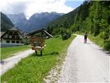 2
2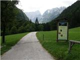 3
3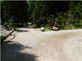 4
4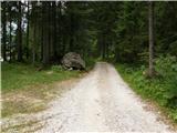 5
5 6
6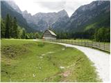 7
7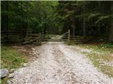 8
8 9
9 10
10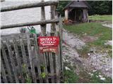 11
11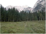 12
12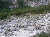 13
13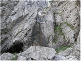 14
14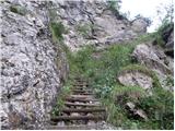 15
15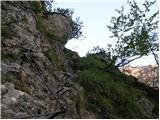 16
16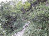 17
17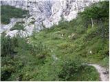 18
18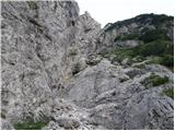 19
19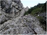 20
20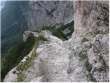 21
21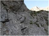 22
22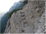 23
23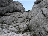 24
24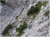 25
25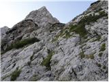 26
26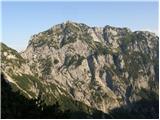 27
27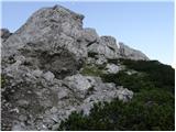 28
28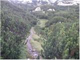 29
29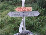 30
30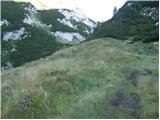 31
31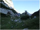 32
32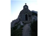 33
33
Discussion about the trip Robanov kot - Chapel on Molička planina
|
| acjom25. 05. 2009 |
Maybe someone knows if there's still any snow on this path, thanks
|
|
|
|
| geppo25. 05. 2009 |
If you look at the photos (general discussions) towards Ojstrica and V. vrh you'll see a lot of snow patches still. So, you can expect snow on the path.
Best regards
|
|
|
|
| anonimnae24. 06. 2024 09:58:51 |
Is there still any snow on the path from Robanov kot to Molička planina?
|
|
|
|
| geppo24. 06. 2024 19:45:46 |
More than a week ago I talked to a guy (on Ojstrica) who came up here. He said there's no snow and no problems on the path!
lp
|
|
|
|
| zajla4201. 08. 2024 20:23:10 |
This path is by no means just a "demanding marked path". It is well secured but, in my opinion, it still deserves the title of "very demanding marked path".
Safe steps to all who decide to ascend this path.
|
|
|
|
| garmont2. 08. 2024 21:20:37 |
It doesn't change anything, but this path has always been marked on all maps as a "demanding" path.
Completely objectively, in my opinion.
|
|
|
|
| Marx3. 08. 2024 06:59:19 |
The very demanding part of this path is only the pegs and cable on picture 22... everything else fits into a demanding path.
What makes this path quite demanding is the fact that we are in the demanding section (From the waterfall to the pass below Žvižgovec) for more than an hour. And that on very scree-covered ground.
|
|
|
To post a comment you must log in:
If you do not yet have a username, you must first
register.