Rogarjev rovt - Hruška planina (via cart track)
Starting point: Rogarjev rovt (1175 m)
| Latitude/Longitude: | 46,46400°N 14,01110°E |
| |
Route name: via cart track
Walking time: 30 min
Difficulty: easy unmarked way
Elevation gain: 203 m
Elevation difference along the route: 203 m
Map: Karavanke - osrednji del 1:50.000
Recommended equipment (summer):
Recommended equipment (winter):
Views: 10.635
 | 3 people like this post |
Access to starting point:
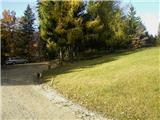
From the Ljubljana–Jesenice highway, take the Lipce exit and follow the road towards Jesenice, where signs for Planina pod Golico direct us to an ascending road (third signalized intersection from the center or the railway station). The steep road brings us to an intersection, where we turn left across a bridge towards Plavški Rovt. When we arrive in the village, we follow the road further to the place where the asphalt ends. After the village, the road descends a little; we encounter its right branch, but we drive further straight ahead. When we get to a smaller hamlet, at the intersection we notice a wooden signpost "Dovje 9 km". Here we turn sharply left and continue on a winding forest road for another 3 km, after which we arrive at a larger rovt with holiday cottages on the left. Right, at a larger bend we notice a cart track which leads through a meadow, uphill towards the north. We park at an appropriate place nearby.
Route description:
We start on the mentioned cart track similar road (almost unfit for driving with a personal car), uphill towards the north. It quickly brings us into the forest, where it starts to ascend quite steeply. When the path turns a little to the right and splits, we continue on the right one, increasingly steep uphill. The path increasingly takes on the appearance of a maintained forest road. After a few zigzags, the steepness gradually begins to ease; finally, when a view towards the Rožca saddle and Klek opens on the right, the road levels out completely. After a short time, the path rises slightly again, and soon we encounter a fence with a gate or barrier. We enter the mountain pasture, where we first see Hruški Vrh, and the path, through a few turns, after crossing the stream and the last short ascent, brings us to the shepherd's hut on Hruška planina. On the wall, in front of the entrance to the hut, we will notice the attached logbook box.
Photos:
 1
1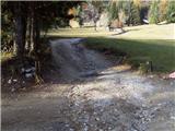 2
2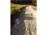 3
3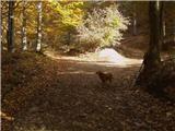 4
4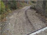 5
5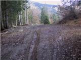 6
6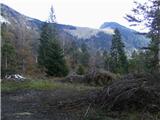 7
7 8
8 9
9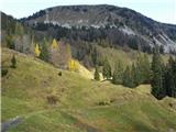 10
10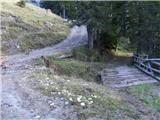 11
11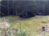 12
12 13
13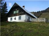 14
14 15
15
Discussion about the trip Rogarjev rovt - Hruška planina (via cart track)
|
| Majdag10. 05. 2010 |
Thanks for the description, I've already been there, but didn't know exactly where I was walking, cheers!
|
|
|
|
| heinz12. 05. 2010 |
Otherwise, you can also get there from Martinčev rovt without problems (up the slope through the meadow, then left into the forest) - good half hour.., but if you haven't been there yet, it's better to follow the above description, otherwise you'll get lost. Then 
Maybe we'll meet up there sometime..
Best regards, heinz!
|
|
|
|
| DejanS24. 03. 2012 |
On 23.3. I lost my Adidas sunglasses on the cart track from Rogarjev rovt towards the planina. If anyone finds them, please let me know.
|
|
|
|
| zelenec3. 05. 2013 |
I'm interested if there is any approach from Hrušica (or surroundings) to Hruška planina that would entirely (or max) follow a trail? I only found the description from Rogarjev rovt, which is an uninteresting road. What about the paths:
- Belo polje-Za krajem-Na visokih-Hruška planina
- or more to the east through Vršiče and Suhi vrh?
best regards
|
|
|
|
| heinz3. 05. 2013 |
Yes, apparently from Belo polje somewhere along the Presušnik stream, but of course not always along the bed, the path should stay more to the right -Kladje. After crossing the road near the hunting hut, follow the track to the right uphill. The path(s) lead(s) along the slope of Črničja either to its top or to Hr. planina. Hruščani do walk it.. By Dobršnik, which is somehow closest to Rogarjev rovt, it's too demanding, no path (anymore). On the map, a track is drawn along the left bank of Dobršnik along the slope of Vršičev, near Suhi vrh the above-described path runs.
|
|
|
|
| stanko127. 04. 2014 |
What about the path: Dovje - Ravne - Hruška planina?
|
|
|
|
| Edina27. 04. 2014 |
At Rogarjev rovt there is a sign that the path towards Dovje is closed due to timber extraction.
|
|
|
|
| Jusk26. 09. 2020 |
Already in the morning I planned to check out the fresh snow somewhere, so I decide on that mountain  the whole planina is wet or soaked as if walking through a marsh rain last night and snowmelt, streams flowing everywhere. Otherwise pleasant autumn weather, just the right temperatures the whole planina is wet or soaked as if walking through a marsh rain last night and snowmelt, streams flowing everywhere. Otherwise pleasant autumn weather, just the right temperatures
|
|
|
To post a comment you must log in:
If you do not yet have a username, you must first
register.