Rudno polje - Ablanca (via Jezerca and Studorski preval)
Starting point: Rudno polje (1340 m)
| Latitude/Longitude: | 46,34580°N 13,92360°E |
| |
Route name: via Jezerca and Studorski preval
Walking time: 2 h 30 min
Difficulty: difficult unmarked way
Elevation gain: 664 m
Elevation difference along the route: 700 m
Map: TNP 1:50.000
Recommended equipment (summer): helmet
Recommended equipment (winter): helmet, ice axe, crampons
Views: 12.490
 | 1 person like this post |
Access to starting point:
From the Ljubljana - Jesenice motorway, take the Lesce exit and continue towards Bled. In Bled, at the traffic light, the signs for Pokljuka direct us to the right. We continue through Gorje and past the abandoned Zatrnik ski slope to Rudno polje on Pokljuka (large parking lot, barracks and shooting range).
Route description:
From the large parking lot opposite the barracks at Rudno polje, first cross the road, then find the start of the forest road (signs for Triglav are also at the beginning of the forest road), leading towards the Viševnik ski slope. After about 10 minutes walking along this road, we reach the foot of the ski slope, where the marked path splits into two. The right path leads to Viševnik and Blejska koča na Lipanci, while we continue briefly along the road towards Triglav, Vodnikov dom na Velem polju and Studorski preval. When the road re-enters the forest, we notice a marked trail on the left, which starts gently and then moderately ascends through the forest. After a few minutes we return to the road at a medium-sized parking lot with space for about 20 cars, but parking has been prohibited here for some time.
After reaching the parking lot, walk a few dozen meters along the road, then the signs lead slightly right onto a marked and well-trodden path that begins to ascend through the forest. After a few minutes the path levels out and gradually enters the relatively steep southern slopes of Plesišče (1790 m). A few minutes of traversing follow, then we reach a ridge of the aforementioned peak. Here the marked path turns right (straight down leads an unmarked but well-trodden path to Planina Konjščica) and descends a bit further. A little ahead, we will see Planina Konjščica to our left below us. Our path then stops descending and transitions from forest to scrub. The ascending path leads us under steep rocky cliffs and soon brings us to a junction where we join the path from Planina Konjščica. A short ascent follows and the path leads us into a beautiful valley called Jezerce, where the path levels out.
At the beginning of Jezerce, where there is also a marked junction, continue left (right to Srenjski preval and Viševnik) towards Studorski preval, Vodnikov dom and Triglav.
Easy walking follows to a sign indicating the central area of TNP, then the path begins to moderately ascend along a stream bed (initially a spring). Higher up the path crosses to the right side of the stream (viewed from the ascent direction) and then traverses up to Studorski preval, from which a nice view opens to the Bohinj side.
At the pass, where we leave the markings, go left up a small path. The path quickly leads to loose terrain where stones can be easily triggered, so be careful. A steeper path follows, leading to the ridge. Follow this path, which is quite dangerous for slipping (due to loose sand on the path), to the summit of Ablanca.
Starting point - Taborni prostor 0:10, Taborni prostor - Klanci 1:25, Klanci - Jezerce 0:05, Jezerce - Studorski preval 0:30, Studorski preval - Ablanca 0:20.

Along the route: Taborni prostor (1369m), Klanci (1678m), Jezerce (1719m), Izvir pod Studorskim prevalom (1746m),
Studorski preval (1892m)
Photos:
 1
1 2
2 3
3 4
4 5
5 6
6 7
7 8
8 9
9 10
10 11
11 12
12 13
13 14
14 15
15 16
16 17
17 18
18 19
19 20
20 21
21 22
22 23
23 24
24 25
25 26
26 27
27 28
28 29
29 30
30 31
31 32
32 33
33 34
34 35
35 36
36 37
37 38
38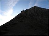 39
39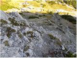 40
40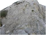 41
41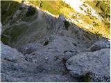 42
42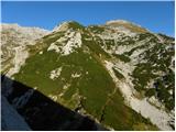 43
43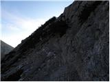 44
44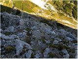 45
45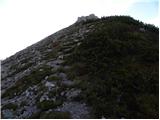 46
46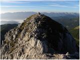 47
47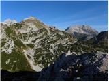 48
48
Discussion about the trip Rudno polje - Ablanca (via Jezerca and Studorski preval)
|
| J.P.13. 01. 2020 |
Trail done Sunday, 12.1. Icy patches here and there to Jezerce, from Jezerce good snow for winter gear. Conditions good to Ablanca summit and extension to Viševnik. Regards
|
|
|
|
| Hribolazec8119. 08. 2023 21:18:04 |
Was there today, beautiful view of Tosc, both Draška vrha, Viševnik and many peaks of the Julian Alps.
If you're already at Studorski preval, it's worth going to Ablanca too, it's nice, the path a bit climbing, for hikers who do very demanding paths it's normal, for those with fear of heights or unsure of their ability, better go with a guide, because the path is a bit climbing, also airy and full of scree on slabs, slippage can happen quickly, so careful steps 
|
|
|
To post a comment you must log in:
If you do not yet have a username, you must first
register.