Rudno polje - Triglav (via Dom Planika and Mali Triglav)
Starting point: Rudno polje (1347 m)
| Latitude/Longitude: | 46,34580°N 13,92360°E |
| |
Route name: via Dom Planika and Mali Triglav
Walking time: 6 h 25 min
Difficulty: very difficult marked way
Elevation gain: 1517 m
Elevation difference along the route: 1775 m
Map: TNP 1:50.000
Recommended equipment (summer): helmet, self belay set
Recommended equipment (winter): helmet, self belay set, ice axe, crampons
Views: 17.620
 | 2 people like this post |
Access to starting point:
From the Ljubljana-Jesenice motorway, take the Lesce exit and continue on the road towards Bled. In Bled, at the traffic light with signs for Pokljuka, turn right. Continue driving through Gorje and past the abandoned Zatrnik ski slope to Rudno polje on Pokljuka (large parking lot, barracks and shooting range).
Route description:
At the end of the parking lot, a gravel road branches off to the right, with signposts for Triglav. Head onto this road, which gently ascends and after ten minutes of walking brings you to the Viševnik ski slope. Continue along the road, from which a marked path to Triglav soon branches off to the left.
Continue towards Triglav and after a few minutes of moderate ascent, you reach a forest road, which you follow for just a few meters (it used to be possible to drive by car up to here). The marked path then turns right and ascends more steeply for a short time, after ten minutes the steepness eases, and the path gradually leads onto steep slopes. Across the steep slopes, the path mostly gently descends and turns increasingly to the right. A bit further on, you will notice the Konjščica pasture to the left below us. Our path then stops descending and transitions from the forest into dwarf pines. The ascending path leads us under steep cliffs and soon brings us to a junction where we join the path from the Konjščica pasture.
From here, a short ascent follows, and the path brings us to a beautiful valley called Jezerce, where it forks. There are also signposts directing left (right Srenjski preval, Viševnik Blejska koča na Lipanci...), and our initially easy path leads to the spring below Studorski preval. After the spring, the path gradually becomes steeper, crossing from the left side of the torrent higher up to the right side, where we reach a grassy slope; the path we ascend remains rocky. An ascent in a few switchbacks follows, and we climb to Studorski preval, from which a beautiful view opens up to the mountains above Bohinj.
Here, a demanding path from Srenjski preval joins us from the right, and from our path, unmarked trails also branch off to Ablanca and Veliki Draški vrh.
From the saddle, we first descend steeply for a short time, then the path turns right, and we traverse the slopes to the left for a longer time with some shorter easy ascents and descents. From the slopes of Veliki Draški vrh, we gradually reach the slopes of the massive Tosc, continuing with beautiful views past the branch to Tosc and the junction where the path from Uskovnica joins from the left.
At all junctions, including the one where a partly abandoned path leading over Planina Zgornji Tosc joins, continue straight; the path gradually leads to steeper and even exposed southwestern slopes of Tosc mountain, where there was a landslide a few years ago, so extra caution is needed due to falling rocks. Across the exposed section runs a fairly wide path, so there are no special difficulties here, and when the slope becomes less steep, the path from Stara Fužina or Voje valley joins from the left.
Continue straight on the wider marked path towards Triglav, which continues north, leading us along the western slopes of Tosc; the still easy path brings us over some scree to Vodnikov dom on Velem polju, where the next junction is.
Here too, continue straight towards Triglav; the path begins to ascend transversely along the slopes of Vernar, becoming technically demanding higher up. Some traversing follows, aided by a fixed cable, higher up we reach a steep drop where we ascend rocky steps with the help of numerous pegs and a cable.
The path ahead levels out, the slope becomes less steep, and near Konjsko sedlo also somewhat more grassy.
We easily descend to Konjsko sedlo, from the marked junction on the saddle head left towards Dom Planika pod Triglavom (straight Triglavski dom na Kredarici and Dom Valentina Staniča pod Triglavom, right Krma) and begin a fairly steep ascent to the west. For a while, we approach Mokra skala (2266 m), then the path turns right and transitions to an indistinct ridge, where it levels out temporarily. The marked path higher up bypasses a small cirque on the right side, then begins turning to the left. Another approximately ten minutes of ascent follows, and with beautiful views of the Triglav massif and surrounding mountains, we reach Dom Planika pod Triglavom.
Bypass the mountain hut on the right side and continue towards Triglav over Mali Triglav (slightly left Triglav via Triglavska or Bovška škrbina, sharply left Koča na Doliču), where we first descend a bit, then begin ascending a gradually steeper slope. Soon we reach a rocky section where we transversely ascend an exposed ledge, after which the path temporarily becomes easier. The path ahead turns right and ascends through scree to a climbing section, directed by a large mark visible from afar.
Continue the ascent along the distinct secured gully, where with the help of a cable we climb to a beautiful viewpoint where the path turns left. A steep ascent follows over rugged rock, where frequent fixed protections assist on the more difficult and exposed sections.
Higher up, we reach the ridge of Mali Triglav, where we join the usually more frequented path from Kredarica.
Continue straight, or slightly left (right down Kredarica) and quickly reach the summit of Mali Triglav.
From Mali Triglav, a slight descent follows along an occasionally less exposed ridge; when we start ascending again, the ridge narrows, and the path becomes exposed on both sides. Further on, there are some quite steep ascents, the path is mainly well protected with cables and individual pegs, and on nice days there may be delays due to meeting hikers up to the summit. Below the summit, the path becomes less demanding but still exposed. Just below the summit, a path to Staničevo zavetišče (emergency bivouac carved into the Triglav massif) branches slightly left; we follow the still cautious but last few meters less steep path to Aljažev stolp, located on the summit of Triglav, the highest peak of the Julian Alps and Slovenia.
Starting point - Taborni prostor 0:10, Taborni prostor - Klanci 1:25, Klanci - Jezerce 0:05, Jezerce - Studorski preval 0:30, Studorski preval - Planina Zgornji Tosc 0:35, Planina Zgornji Tosc - Na Zagonu 0:20, Na Zagonu - Vodnikov dom 0:20, Vodnikov dom - Konjsko sedlo 0:30, Konjsko sedlo - Planika 1:00, Planika - Mali Triglav 0:55, Mali Triglav - Triglav 0:35.

Along the route: Taborni prostor (1369m), Klanci (1678m), Jezerce (1719m), Izvir pod Studorskim prevalom (1746m),
Studorski preval (1892m), Planina Zgornji Tosc (1849m), Na Zagonu (1819m),
Vodnikov dom (1817m), Konjsko sedlo (2020m),
Dom Planika (2401m),
Mali Triglav (2725m)
Photos:
 1
1 2
2 3
3 4
4 5
5 6
6 7
7 8
8 9
9 10
10 11
11 12
12 13
13 14
14 15
15 16
16 17
17 18
18 19
19 20
20 21
21 22
22 23
23 24
24 25
25 26
26 27
27 28
28 29
29 30
30 31
31 32
32 33
33 34
34 35
35 36
36 37
37 38
38 39
39 40
40 41
41 42
42 43
43 44
44 45
45 46
46 47
47 48
48 49
49 50
50 51
51 52
52 53
53 54
54 55
55 56
56 57
57 58
58 59
59 60
60 61
61 62
62 63
63 64
64 65
65 66
66 67
67 68
68 69
69 70
70 71
71 72
72 73
73 74
74 75
75 76
76 77
77 78
78 79
79 80
80 81
81 82
82 83
83 84
84 85
85 86
86 87
87 88
88 89
89 90
90 91
91 92
92 93
93 94
94 95
95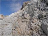 96
96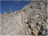 97
97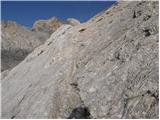 98
98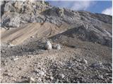 99
99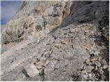 100
100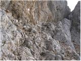 101
101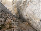 102
102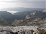 103
103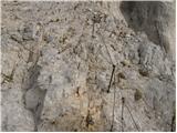 104
104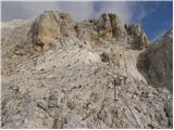 105
105 106
106 107
107 108
108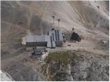 109
109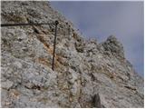 110
110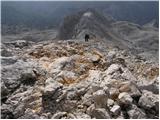 111
111 112
112 113
113 114
114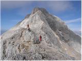 115
115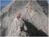 116
116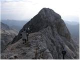 117
117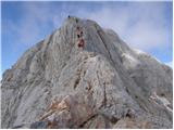 118
118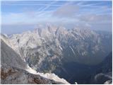 119
119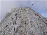 120
120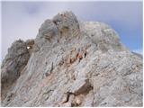 121
121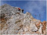 122
122 123
123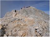 124
124 125
125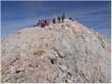 126
126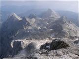 127
127 128
128
Discussion about the trip Rudno polje - Triglav (via Dom Planika and Mali Triglav)
|
| Lunca3. 08. 2023 14:08:30 |
What is the road like from Rudno polje to the smaller parking lot? Thanks
|
|
|
|
| 1muha3. 08. 2023 14:33:36 |
|
|
|
|
| Lunca3. 08. 2023 17:53:38 |
|
|
|
To post a comment you must log in:
If you do not yet have a username, you must first
register.