Rudno polje - Veliki Draški vrh (via Jezerca and Studorski preval)
Starting point: Rudno polje (1347 m)
Starting point Lat/Lon: 46.3458°N 13.9236°E 
Path name: via Jezerca and Studorski preval
Time of walking: 3 h 20 min
Difficulty: partly demanding unmarked way
Difficulty of skiing: no data
Altitude difference: 896 m
Altitude difference (by path): 930 m
Map: TNP 1:50.000
Access to starting point:
From highway Ljubljana - Jesenice we go to the exit Lesce and follow the road ahead towards Bled. In Bled at the traffic lights, the signs for Pokljuka point us to the right. Ahead we drive through Gorje and past the abandoned ski slope Zatrnik to Rudno polje on Pokljuka (large parking lot, barracks and shooting range).
Path description:
From a large parking lot opposite the barracks on Rudno polje at first we cross the road, and then we look for the beginning of the forest road (by the beginning of the forest road are also signs for Triglav), which leads towards the ski slope Viševnik. After approximately 10 minutes of walking on the mentioned road we get to the foot ski slope, where the marked path splits into two parts. The right path leads towards Viševnik and mountain hut Blejska koča na Lipanci, and for a short time, we still continue on the road in the direction of Triglav, mountain hut Vodnikov dom na Velem polju and Studorski preval. When the road returns into the forest, we will on the left notice a marked footpath which starts gently and higher moderately ascending through the forest. After few minutes, we step back on the road which we reach on medium-sized parking lot, where there is enough space for about 20 cars (to here it is possible also with a car, this shortens the path for approximately 20 minutes).
When we reach the parking lot, few 10 meters we walk on the road, and then signs lead slightly right on a marked and well-beaten path which starts ascending through the forest. After few minutes, the path flattens and gradually passes on a relatively steep southern slopes of Plesišče (1790 meters). Next follows few minutes of crossing, and then we step on some kind of broad ridge of the before mentioned summit. Here the marked path turns right (straight downwards leads unmarked, but well-beaten path towards Planina Konjščica) and descends a little. A little further, we will notice left below us the mountain pasture Konjščica. Our path then stops descending and passes out of the forest into dwarf pines. The path which is again ascending then runs below the steep rocky cliffs and soon after that, it brings us to a crossing, where we join the path from the mountain pasture Planina Konjščica.. Next follows a shorter ascent and the path brings us into a nice small valley named Jezerce, where the path flattens.
At the beginning of Jezerce, where there is also a marked crossing we continue left (right saddle Srenjski preval and Viševnik) in the direction of saddle Studorski preval, Vodnikov dom and Triglav.
Next follows easy walk to the signpost, which marks the main area of TNP, and then the path starts moderately ascending by the torrent (at first a well). The path higher passes on the right side of the torrent (looking from the direction of ascent) and then it ascends diagonally to a saddle Studorski preval, from which a nice view opens up to Bohinj side.
From the saddle Studorski preval we continue right (left Ablanca, straight Vodnikov dom, sharply right Srenjski preval) on at first gently sloping path, which is ascending through a lane of dwarf pines. A little further, the path turns to the left and starts gradually ascending steeper and steeper. After few minutes of additional walking, the path brings us below short, but quite steep rocky jump, which we overcome with some help of hands (mainly for balance). Rocky jump is besides a risk of slipping, exposed also to falling stones (carefully!). Higher, the path flattens and passes on very panoramic and technically mostly undemanding ridge. The path, from which beautiful views opening up on Spodnje Bohinjske gore and also other Bohinj mountains, a little below the summit again starts ascending steeper. The path ahead ascends over short and steep rocky slope, and then it flattens and in few minutes of additional walking brings us on a panoramic peak.
Rudno polje - Studorski preval 2:20, Studorski preval - Veliki Draški vrh 1:00.
On the way: Studorski preval (1982m)
Pictures:
 1
1 2
2 3
3 4
4 5
5 6
6 7
7 8
8 9
9 10
10 11
11 12
12 13
13 14
14 15
15 16
16 17
17 18
18 19
19 20
20 21
21 22
22 23
23 24
24 25
25 26
26 27
27 28
28 29
29 30
30 31
31 32
32 33
33 34
34 35
35 36
36 37
37 38
38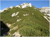 39
39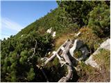 40
40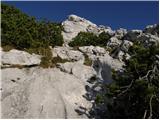 41
41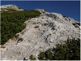 42
42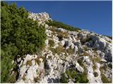 43
43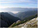 44
44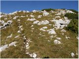 45
45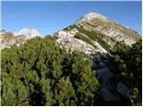 46
46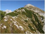 47
47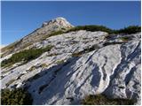 48
48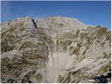 49
49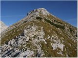 50
50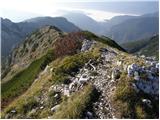 51
51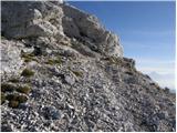 52
52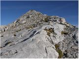 53
53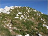 54
54 55
55 56
56