Starting point: Rudno polje (1347 m)
| Latitude/Longitude: | 46,34580°N 13,92360°E |
| |
Walking time: 2 h
Difficulty: easy marked way
Elevation gain: 703 m
Elevation difference along the route: 703 m
Map: Triglav 1.25.000
Recommended equipment (summer):
Recommended equipment (winter): ice axe, crampons
Views: 462.867
 | 18 people like this post |
Access to starting point:
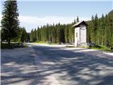
From the Ljubljana - Jesenice motorway, take the Lesce exit and continue towards Bled. In Bled, at the traffic lights, signs for Pokljuka direct you to the right. Continue through Gorje and past the abandoned Zatrnik ski resort to Rudno polje on Pokljuka (large parking lot, barracks and shooting range).
Route description:
At the end of the parking lot a gravel road branches off to the right along which there are signposts for Triglav. We turn onto this road, which gently ascends and brings us to the ski resort after ten minutes.
On the other side of the ski resort, next to the ski lift, we will notice a marked footpath that continues to the right from the road. We take the mentioned path, which in a moderate ascent through a belt of forest brings us to a gravel road (up to here also possible by road), which we follow to the right, but only a few steps. Just before the road crosses the ski slope, a marked footpath branches off to the left, which first crosses a pasture fence, then ascends along the edge of the ski slope. At the top of the first ski lift the marked path turns left and then begins to ascend more steeply along the edge of the second steeper ski slope. The second ski lift also ends soon, and we continue along the path which enters a smaller relatively steep valley. Towards the top of the mentioned valley the path ascends relatively steeply, then suddenly levels out and brings us past an abandoned hunting observation post to a junction.
We continue straight in the direction of Viševnik (right Lipanca and Viševnik via Kačji rob) along an again steeper path, which after a few minutes of further walking brings us to a small saddle, from which a nice view opens to the Bohinj-Tolmin mountains, sometimes called the Lower Bohinj mountains.
At the saddle we continue right along a wide mountain path, which then ascends through a belt of dwarf pines. We soon leave the dwarf pines and the path brings us to relatively steep grassy slopes, across which we then climb to the ridge of Viševnik. This is followed by a short traverse of a rocky slope, then we pass below the summit of Viševnik itself. Here the path steeply ascends and after a few more steps of walking brings us to the panoramic summit.
In winter time the upper part of the path is exposed to avalanches, there is also a great danger of slipping.
Rudno polje - Planinski taborni prostor 0:10, Planinski taborni prostor - Planina Krasca 0:05, Planina Krasca - Zlata voda 0:50, Zlata voda - sedlo pod Plesiščem 0:10, sedlo pod Plesiščem - Viševnik 0:45.

Along the route: Planinski taborni prostor (1369m), Planina Krasca (1402m), Zlata voda (1717m), Sedlo pod Plesiščem (1780m)
Photos:
 1
1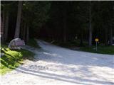 2
2 3
3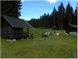 4
4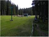 5
5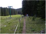 6
6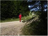 7
7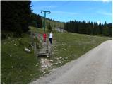 8
8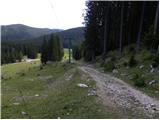 9
9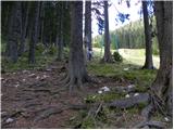 10
10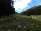 11
11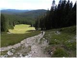 12
12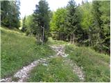 13
13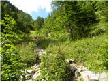 14
14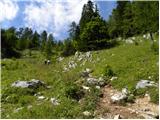 15
15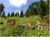 16
16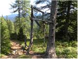 17
17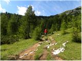 18
18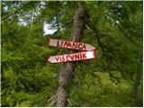 19
19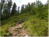 20
20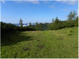 21
21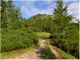 22
22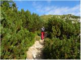 23
23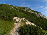 24
24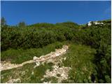 25
25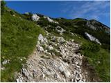 26
26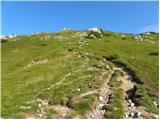 27
27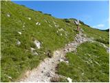 28
28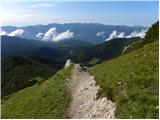 29
29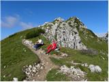 30
30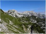 31
31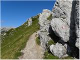 32
32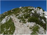 33
33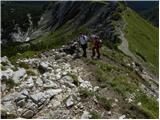 34
34 35
35
Discussion about the trip Rudno polje - Viševnik
Show older messages
|
| Gost4. 04. 2007 |
I'm interested in the conditions on the path to Viševnik for Saturday 5. 4. 2007
|
|
|
|
| Gost29. 04. 2007 |
extremely nice path with wonderful views
|
|
|
|
| Gost1. 05. 2007 |
we decided we must see this as soon as possible ...
|
|
|
|
| Gost2. 05. 2007 |
Is there still a lot of snow?
|
|
|
|
| Gost5. 05. 2007 |
is the tree with nails safe?
|
|
|
|
| Gost5. 05. 2007 |
I haven't heard yet that anyone fell down!
|
|
|
|
| Gost19. 05. 2007 |
I visited Viševnik today and I can say I returned with wonderful impressions. The view from these hills is something a person must experience. Anyway, it holds true, 1:45 hours to the top! The trail is quite challenging but not dangerous, so I recommend it also for families with elementary school children!
|
|
|
|
| AndrejK23. 05. 2007 |
I too was at Viševnik last Saturday. Exceptional day that offered truly beautiful views. No heat either. You only encounter snow further ahead below Velikim Draškim vrhom and between Studorskim prevalom and Jezercami. But it doesn't hinder walking.
|
|
|
|
| bazo26. 07. 2007 |
PHENOMENAL VIEW OF TRIGLAV
|
|
|
|
| Gost27. 07. 2007 |
Suggestion: go to Viševnik also in autumn, when larches start turning yellow. Very, very nice... Good luck!
|
|
|
|
| Gost29. 07. 2007 |
Yesterday it was wonderful, sunny day, wonderful view! Whoever hasn't been there yet must go on the trail!
|
|
|
|
| Gost3. 08. 2007 |
very nice easy hike, worth every step, we recommend
|
|
|
|
| nadjau16. 08. 2007 |
Due to heavy traffic we started our holiday trip at Rudno polje with "a little delay". We started only at 10:30. The path matches the description; not demanding, but continuously exciting and with every step opening new views. Visibility at noon was good, binoculars allowed us to see the "line" of hikers on ridges and valleys around Triglav and neighboring mountains. Crowd at the top - all satisfied hikers (including foreigners).
We returned via the longer but more pleasant path under Debelim hribom to Planina Lipanco, where we met friends who were "conquering" Debele peči that day. Then descent and we skewered the sausage.
We turned a short ascent into a full-day trip - less crowded paths offer more peace, silence, mystery, magic..... Recommended!
|
|
|
|
| Gost16. 08. 2007 |
Repeat this trail in October when the larches are golden. I tell you, it's really beautiful! Good luck!
|
|
|
|
| Gost20. 09. 2007 |
Brane V.- today was on Viševnik. At the top wonderful view of Triglav. Short tour, suitable for everyone.
|
|
|
|
| Gost13. 01. 2008 |
We are deciding for the ascent to Viševnik. What is the avalanche danger like at the beginning of February.
And what equipment would we need, anything special?
Thanks
Best regards
|
|
|
|
| Gost13. 01. 2008 |
What the avalanche danger will be in February is not known yet. As for equipment, ice axe and crampons, in favorable conditions you don't need anything special. Just have the ice axe and crampons in reserve anyway, so you don't stay 10m below the summit.
|
|
|
|
| heinz29. 06. 2008 |
Yesterday we were first. It was a pleasant less demanding trip. At the top there is a lack of space, so visitors should be considerate of each other or enable safe encounters! (A similar problem occurs/happens on other peaks with smaller surface area..) Given the crowds that occasionally happen in some places and the inconsiderateness of some visitors, I am surprised by the relative rarity of accidents.
|
|
|
|
| benko10. 07. 2008 |
I'm wondering if this path is also suitable for a dog? Best regards
|
|
|
|
| katjuša210. 07. 2008 |
Of course it's suitable for a dog
but since there are also pastures along the way, take a leash with you, and maybe go earlier in the morning, because during the day many people go up to the summit and some impatient one might get among them
|
|
|
|
| Gostja9. 08. 2008 |
Viševnik obsessed me for a while because so much beautiful was written about it. It disappointed me a little, perhaps because I have experienced many better views, or because personally I prefer trails that go hard on and between rocks. The somewhat lengthy trail is easy, that's true, but it's tense all the time and for those with knee problems I recommend poles. I satisfied my wish, but I won't visit it again soon. But I can add that my friend and I were the only ones on the summit around 17:30. Advantage if you go a bit later. LP
|
|
|
|
| gino12. 09. 2008 |
Since the weather forecast for the entire next week is very bad, despite my afternoon job I decided on a short morning visit to this wonderful mountain. I am a regular visitor to Viševnik in all seasons. But every visit is unique and unforgettable. The weather was ideal, very few people on the path. For good mood, a solitary edelweiss flower a bit off the main path delighted me, which I saw on this hill for the first time. Best regards to all.
|
|
|
|
| stamario5. 07. 2009 |
Hribi net, that's the law this is what I call a quality path description....in a couple of days I'm going with the kid to Viševnik, and I'll send impressions
|
|
|
|
| velikanka31. 08. 2009 |
The summit is nothing special, we've seen much nicer ones, but I agree that the route is somehow "tense" all the time. Trip suitable for families! I set off early and it was beautiful because I was among the few up there. Definitely set off in the early hours if you don't like crowds of people.
|
|
|
|
| heinz31. 08. 2009 |
I don't agree with you, giantess!
There are always certain peaks prettier for some than others, but in most cases it's just a subjective assessment. If "you" have already seen quite a few prettier ones, I certainly wish you well, but "we" also really like Viševnik. After all, this peak is such a popular goal also because of its attractive location. I believe that a crowd of hikers gladly returns to Viševnik, who may have visited more (beautiful) peaks than "we".
No hard feelings, but enjoy everywhere it's prettier for you than in the long-boring grayness of the valley!
|
|
|
|
| velikanka1. 09. 2009 |
Certainly just a subjective opinion... that's what the forum is for, right... everyone sees it differently and it wasn't meant as the opinion of the majority...
|
|
|
|
| viharnik1. 09. 2009 |
Viševnik is a worthwhile tour in winter. The summit is quite panoramic and really invites one to climb above 2000 meters and see Triglav, which is as if on the palm of your hand. Due to its accessible location, it works well in winter even in bad weather to check the snow cover and hurry back to the valley. In short, Viševnik always fascinates me anew and offers approaches from the south, from the east via Srenjski preval, or from Jezerca in the west.
|
|
|
|
| urshy22. 09. 2009 |
Does anyone perhaps know what the path from Viševnik over Mali and then to Veliki Draški vrh is like?
|
|
|
|
| kamchatka19. 11. 2009 |
Does anyone know if the path to Viševnik from Rudno polje is trodden? - can one go without crampons? thanks a lot k.
|
|
|
|
| krnice20. 11. 2009 |
I'm also interested in how the snow is on Viševnik, because we're going up on Sunday. Lp M
|
|
|
|
| triglavski20. 11. 2009 |
Well, if you click a bit on the Forum-conditions you would probably quickly find answers (middle column)
|
|
|
|
| kofetarca21. 11. 2009 |
The path is trodden, snow only on top of the ski slope and to the saddle...towards the summit bare, just patches, crampons not needed.
|
|
|
|
| kamchatka21. 11. 2009 |
Thank you very much for the answers, tomorrow we will definitely go
|
|
|
|
| brencelj4. 02. 2010 |
Interested if anyone has been to Viševnik recently
and what the access is like
|
|
|
|
| dajnar15. 02. 2010 |
My friend and I were up there on Wednesday 3.2.2010. Access without problems, maybe only the immediate descent from the top is a bit tricky, but even that is no problem with a bit more caution. Conditions will certainly change in these days.
|
|
|
|
| NinaR7. 02. 2010 |
hm, I think Viševnik is usually not problematic, even if it's not trodden yet, but it's more strenuous for the first one who breaks trail,
stick to the ridge
|
|
|
|
| kris28. 04. 2010 |
tomorrow I would go with my son to Viševnik has anyone been up there recently what's the path like
|
|
|
|
| salvinia28. 04. 2010 |
On Monday there was snow practically everywhere from the top of the upper chairlift, in the early morning hours it was nice to walk and it didn't sink in, just below the summit and on the summit it was a bit icy. The path is trodden to the extent that you can walk in the footsteps of predecessors.
|
|
|
|
| kris28. 04. 2010 |
thanks for the information and best regards.
|
|
|
|
| brencelj31. 05. 2010 |
soon I'm setting off to debelo peč
from Pokljuka via Zlate vode towards Lipanci - I'm curious what the path to Lipanci is like - demanding or easy
|
|
|
|
| TilenGruden1. 09. 2010 |
We went to Viševnik last year around mid-autumn, there was some snow halfway along the path. Nice trail, and at the top a magnificent view of Triglav.
lp
|
|
|
|
| ZOJA25. 12. 2010 |
Hi. Has anyone been to Viševnik in the last few days? How much snow? Is the path trodden or do you need crampons? LP
|
|
|
|
| viharnik25. 12. 2010 |
After the last snowfall expect up to 1m of new snow above 1900m. That we need crampons, ice axe, bivouac, two-person tent, avalanche transceiver, warm clothes, stove for two-day tours, helmet, snowshoes, skis, goggles, cream etc. on mountain paths is completely obvious, so that in case of accident or bad weather (fog, snow, wind) we survive in the mountains until descent with improving weather or arrival of the rescue service in case of injury.
|
|
|
|
| brencel14. 01. 2011 |
I'm interested if anyone knows how much snow there is on Viševnik and if crampons are needed
thanks
|
|
|
|
| Parkeljc14. 01. 2011 |
Crampons are not necessary, at most early in the morning when it's still frozen, the weather these days is warm even at this altitude and the freeze thaws quickly. Almost half a meter of new snow has fallen, which has settled a bit in the last two days. Of course take them with you!!
|
|
|
|
| Tadeja7416. 01. 2011 |
Regarding crampons. Yesterday we were up there, not a single hiker (and there were quite a few up there) returned without crampons. Except skiers of course 
Take them with you, then you decide yes or no. Good luck!
|
|
|
|
| JusAvgustin16. 01. 2011 |
That's the most sensible, but do you have crampons in your backpack, yeah and the ice axe is terribly heavy and just a hindrance while hiking. People! In winter season we're repeating for the nth time the mandatory gear: crampons, ice axe, extra warm clothing, headlamp, hot drinks for high mountains and helmet too! Stay safe everyone!
|
|
|
|
| ZOJA5. 03. 2011 |
how is it today at Viševnik? does anyone have first-hand info.....best regards
|
|
|
|
| alesh745. 03. 2011 |
ZOJA...nice weather, path trodden, otherwise CROWDED....
|
|
|
|
| ZOJA5. 03. 2011 |
alesh, thanks for the info...will have to go once during the week....crampons not needed then.....best regards
|
|
|
|
| KristinaG5. 03. 2011 |
 
Crampons are a mandatory companion in the winter season - if not on your feet, then in your backpack!!! Along with the other obligatory gear, of course.
|
|
|
|
| pi21. 04. 2011 |
Does anyone know what the current snow conditions are? Thanks!
|
|
|
|
| Žiga Šubic30. 06. 2011 |
Is parking fee required at Rudno polje?
|
|
|
|
| Rudi2624. 08. 2011 |
Yesterday I was up there, nice summit, easy ascent, suitable for anyone who wants over 2000 m
|
|
|
|
| taurusnero24. 08. 2011 |
In recent years, local municipal inspectors have often lingered on Pokljuka during the summer months, reportedly diligently fining everyone who parked their vehicles in violation of regulations (read: harmed nature, environment....). Last time, I met a man right at Viševnik who, after a few minutes of casual chat about the mountains, explained that he is a "guard" in TNP and that "normal" parking on Pokljuka and similar locations is not an issue. The problem is those drivers who push their vehicles to the extremes off the roads or tracks. He says you can generally park on Pokljuka without problems, just directly by the road or track.
So much about parking on Pokljuka, it probably interests someone since debates flare up every summer on this topic too.
|
|
|
|
| martinza29. 10. 2011 |
I'm curious if anyone knows what the current conditions up there are like? How much snow is there?
|
|
|
|
| Kokta27. 11. 2011 |
Wonderful sunny weather, quite crowded... the view of the neighboring giants is phenomenal.
|
|
|
|
| gnasenb7. 01. 2012 |
I will be starting from Rudno Polje this summer on my quest is to get to the top of Mt. Triglav. I'll be 48 years old and in pretty good shape with good knees. Will hiking boots suffice? Will I need poles? What other equipment will I need for this trek?
|
|
|
|
| jax7. 01. 2012 |
Hiking boots are perfect. Poles are recommended, though if you are used to walking without them then they are not really necessary. Helmet is highly recommended because the summit part is always crowded and falling stones do happen. As far as the necessary equipment goes, this is mostly it. Some people use the ferrata kit as well but in my opinion this is not really necessary. Of course, it is high mountain area so bring enough warm clothes (including cap&gloves) and follow the weather forecasts. This is it, in my opinion.
Btw, the route from Pokljuka is this one:
You can check it out.
|
|
|
|
| bernard.cefarin13. 01. 2012 |
I'm wondering where one could overnight. As far as I know, there are only military buildings. Thanks for the information.
|
|
|
|
| maucec4013. 01. 2012 |
Bernard, there are two hotels on Pokljuka, Šport hotel and Hotel Center. You can also inquire at Blejska koča on Lipanca which is always open, if they have overnight stays in winter time.
|
|
|
|
| Kokta19. 02. 2012 |
Wonderful day to visit Viševnik. Sunny weather with very little wind and pleasant temperatures. No special equipment needed for the ascent. At the top it was fairy-tale like
|
|
|
|
| jelen21. 02. 2012 |
I'm interested if anyone knows what the current conditions up there are? How much new snow is there?
Tomorrow I plan to go up, is the stamp accessible?
|
|
|
|
| redbull21. 02. 2012 |
dude if you're going up, then let us know here, you'll tell how it was, in my opinion there is about 20 cm of new snow if you don't know
|
|
|
|
| redbull21. 02. 2012 |
dude if you're going up, then let us know here, you'll tell how it was, in my opinion there is about 20 cm of new snow if you don't know
|
|
|
|
| redbull21. 02. 2012 |
dude if you're going up, then let us know here, you'll tell how it was, in my opinion there is about 20 cm of new snow if you don't know
|
|
|
|
| jelen22. 02. 2012 |
On Viševnik there is less than 20cm of new snow, the trail is well trodden so no problem.
|
|
|
|
| Cetko10. 03. 2012 |
Hi, has anyone been to the summit recently, what's the trail like, is it dry?
best regards
|
|
|
|
| Grega9227. 03. 2012 |
hi
has anyone been up there in the last few days
is there still any snow?
regards
|
|
|
|
| M.A.28. 03. 2012 |
hi,
my dear and I were at Viševnik on Mon. 26.03. great hike. almost no snow, some small patches in shady spots, can bypass on grass. the birds on top will appreciate some breadcrumbs :-)
|
|
|
|
| jvali29. 03. 2012 |
m.a.
thanks for this encouraging news. I've been planning to go up for a while, but on Saturday I'll definitely conquer this summit. Safe steps to all.
|
|
|
|
| Petrca23. 10. 2012 |
On Saturday the weather was as if painted. Sunshine, almost summer temperatures lured numerous hikers.
|
|
|
|
| Iksek9. 11. 2012 |
Is there any snow up there?
|
|
|
|
| katja8720. 11. 2012 |
On Saturday, 17.11.2012, we set off along this path to the top of Viševnik. The weather was sunny, but the wind was also bringing cold.
As there was no more snow, we decided to extend the tour to Mali Draški vrh and Visoki Draški vrh. Both paths are unmarked, but the trail is well trodden, so no fear of getting lost. In places there are also cairns. The path from Mali Draški vrh to Veliki is well secured with fixed ropes, completely new ones have been added/renovated in between.
Due to the crumbly rocks on Mali Draški vrh, I recommend a helmet!
Pictures from the hike can be viewed on the website of the Mountaineering Association Matica Murska Sobota: http://www.mojalbum.com/pdmaticams/201v21118-vicevnik-mali-in-vel-draski-vrh/foto/20283404
|
|
|
|
| Divina26. 11. 2012 |
Hello, was anyone on Viševnik last weekend (23-25.11.2012)? What are the conditions, how much snow is there? Regards
|
|
|
|
| lanževica27. 11. 2012 |
I was on Viševnik on Saturday. The path from the ski slope upwards was quite muddy. There was some snow only on the path towards Srenjski preval.
|
|
|
|
| alpinist26. 01. 2013 |
Today we were at Viševnik. There is quite a bit of snow, it was pretty frozen so you could walk on it. Even without crampons because there are tracks made. Some went up with touring skis. Here and there it sinks to your waist but you can walk nicely. And of course it was a really nice sunny day. Best regards
|
|
|
|
| eftomi23. 04. 2013 |
Classic question - has anyone been to Viševnik in the last days? How much snow is left from Rudno polje?
|
|
|
|
| katty23. 04. 2013 |
I was up there last Monday... There's quite a lot of snow, I think it hasn't melted much in a week. I advise going on the trail earlier, because it can sink quite a bit. Below at the ski slope there's a fairly solid base, higher up the condition is worse.
|
|
|
|
| eftomi24. 04. 2013 |
Thanks to both! It will be good for building stamina
|
|
|
|
| Smrečica8. 06. 2013 |
Hi. Does anyone know if there's still any snow on Viševnik. I'd go from Rudno polje. Thanks
|
|
|
|
| ajda8. 06. 2013 |
Hi, I walked around there today. There's none of it, just the path is a bit muddy in some sections
|
|
|
|
| otiv8. 06. 2013 |
You'll see it, but you won't walk on it.
|
|
|
|
| Smrečica8. 06. 2013 |
Thanks. Then I'll go up next Saturday.
|
|
|
|
| Micky28. 06. 2013 |
I was up there on Saturday. It was a beautiful hot day with great views.
|
|
|
|
| laik28. 06. 2013 |
me too, I was up there on Saturday... awesome
|
|
|
|
| ljubitelj gora2. 01. 2014 |
I was there on Wednesday for 1.1 at Viševnik at Rudno polje, about 2 km cars, full of people at the ski slope, I go along the ski slope above it was better. There were quite a few of us up that day, track was there, but for the return on the track slippery, so it's good to have crampons. Lots of snow, sunny weather, no wind, but it was grade 3, more pictures: https://plus.google.com/photos/114400986607884783562/albums/5963969645904579761?sort=1
|
|
|
|
| Abershka2. 07. 2014 |
Hi,
I'm wondering if anyone has been to Viševnik recently and what the conditions are like? Thanks
|
|
|
|
| borovnicka3. 07. 2014 |
On Saturday there was no more snow on the path.
|
|
|
|
| Jaka-Eva30. 10. 2014 |
What are the conditions like on Viševnik?
|
|
|
|
| miha ha13. 12. 2014 |
found a helly hansen jacket/down jacket, black color, at the top of the ski slope along the path
if anyone misses it call
040 938 086
miha
|
|
|
|
| ljubitelj gora4. 01. 2015 |
Conditions above Pokljuka today, more in the album. https://plus.google.com/photos/114400986607884783562/albums/6100596152257797057
|
|
|
|
| Ivan Ivanovski15. 03. 2015 |
Hello. We plan to go to Viševnik next week. I'm interested if someone has been up there recently or what the conditions are like? Thanks for reply. Best regards
|
|
|
|
| barand31. 07. 2015 |
Please kindly provide one clarification. I'm interested how long it would take us to walk along the gravel road from Rudno polje on Pokljuka to the parking lot at the end of the road where the signs for Planina Konjščica begin. Thank you for the answer and best hiking regards.
|
|
|
|
| pikica131. 07. 2015 |
40 min. at a plain ordinary hiking pace.
|
|
|
|
| barand31. 07. 2015 |
Pikica1 thank you very much for the help. So we can do a nice circular route with the family, say from Rudno polje where we park the car to the top of Viševnik via the easy marked path, return via the partially demanding path towards Planina Konjščica and then back towards Rudno polje to the parking lot. So total around under 5 hours of walking. Am I right? Thank you very much and sunny greetings.
|
|
|
|
| urskad22. 10. 2015 |
Does anyone have information on what the conditions are like, is there already snow? Thanks, best regards!
|
|
|
|
| Bojan285722. 10. 2015 |
On the left side there are webcams
best regards
|
|
|
|
| Bojan285722. 10. 2015 |
On the left, that would be more correct
|
|
|
|
| loncaruros5. 05. 2016 |
Good day... has anyone been up there in the last few days? I plan to go tomorrow and I'm interested in the conditions... thanks
|
|
|
|
| dino21. 05. 2016 |
In the summit log box you'll find a Honda car key!
|
|
|
|
| onlyx22. 06. 2016 |
I'm wondering if it's possible to reach Rudno polje from Bled, given that I saw a notice about road renovation on this section?
|
|
|
|
| golica22. 06. 2016 |
was yesterday on Pokljuka, and further of course...regarding the road, yes barriers are marked everywhere, but for "locals" not much changes, so we could drive with a small detour almost on the same road Bled-Gorje-Pokljuka, just for info.
|
|
|
|
| onlyx22. 06. 2016 |
Super, thanks for the information
|
|
|
|
| Zdenkob28. 08. 2017 |
Did this tour yesterday and then extended it over Srenjski preval to Veliki Draški vrh and returned via Studorski preval to Rudno polje. Nice weather and great views.
|
|
|
|
| kr ena28. 09. 2017 |
I'm curious what the path is like, does anyone know? Is there snow, is winter equipment needed?
|
|
|
|
| keti11. 10. 2017 |
Today we were up there in wonderful sunny weather, without fog. No snow on the path.
|
|
|
|
| ljubitelj gora1. 01. 2018 |
On Sundays and holidays when sunny, late arrival at Rudno polje means "parking problem", need to leave car 1km before the parking lot. Depends on the warden. Applies to those heading to Viševnik. Yesterday I left the car about 2km before the parking lot. Late evening I ran that part. Video from Viševnik summit, later after descent to Plesišča decided to go back to Viševnik to watch sunset. https://www.youtube.com/watch?v=W7AxtN52VYY
|
|
|
|
| frajer5. 03. 2018 |
Hello... I'm curious about the conditions on the path to Viševnik? Is a track made? Which path is the most suitable for a winter ascent?
|
|
|
|
| PFranci8. 03. 2018 |
Conditions suitable also for hikers. Trail is the classic one over the ski slope.
|
|
|
|
| kostas24. 07. 2018 |
Hello, on descent from Viševnik towards Rudno polje today, 24.7.2018, I lost Kenwood TH-f7 radio. Thanks to finder if they notify me of the find.
Thank you
s56km1@gmail.com
|
|
|
|
| devill21. 02. 2019 |
Hello ... I'm interested in path conditions
to Viševnik?
|
|
|
|
| Lovec na vzhode2. 01. 2020 |
Hi, on Saturday I'd like to go to Viševnik. Interested in conditions? Possible with microspikes and poles?
|
|
|
|
| modrook127. 06. 2020 |
Hello! But does anyone know how long it takes from Viševnik to the hut at Lipanca?
|
|
|
|
| anzecokl7. 12. 2020 |
Hikers in heavy snowfall on Viševnik, where moments of silence were interrupted by a roaring wind, and at the ski area height also thick raindrops.
PHOTO STORY
|
|
|
|
| Mark714. 04. 2021 17:34:45 |
Hello! I'm interested if anyone is familiar with the conditions on this path to Viševnik
|
|
|
|
| Mark715. 04. 2021 11:36:58 |
primoza Thanks!
|
|
|
|
| modrook1228. 05. 2021 21:24:43 |
Maybe someone knows what the conditions are like on Viševnik? Regards
|
|
|
|
| winni7. 06. 2021 12:36:05 |
I'm also interested in how it is in the mountains above Bohinj, at what altitude does the snow start?
|
|
|
|
| Fulcrum8. 06. 2021 08:28:33 |
I haven't been to Viševnik, but on Saturday (5.6.) I went to Debelo peč. To Blejska koča there's just traces of snow, from there on the conditions are completely wintery. The summits of Debele peči and Brda are snow-free, but on the way there you can't avoid it. In some places at least a meter, judging by how deep I sank in. I didn't need winter gear (crampons).
|
|
|
|
| PV21. 06. 2021 14:03:59 |
Does anyone perhaps know if there's still any snow on this trail to Viševnik?
|
|
|
|
| Gogl21. 06. 2021 17:36:44 |
|
|
|
|
| PV22. 06. 2021 07:37:05 |
@Gogl
Thank you very much.
|
|
|
|
| ljubitelj gora18. 10. 2021 13:46:08 |
The road to the cable car now has a no-traffic sign, smaller and white inside.
|
|
|
|
| BorStenar20. 11. 2022 17:26:13 |
3 years ago I was on Viševnik, which I visited via this trail. My brother (writes comments under the name G34) didn't go, but still view-/trail-/mountain name-
|
|
|
|
| Majdag26. 07. 2023 17:14:59 |
24.7. Ascent via the usual path, descent via Kačji rob. The last part of the upper trail near the rocks towards Srenjski preval is a bit awkward, slippery. Otherwise, there is currently a lot of flowers along the path. You forget about the steepness, it's so beautiful. You just look and admire the beautiful nature. But it was blowing strongly and at the top everyone quickly turned back.
https://jelenkamenmajdag.blogspot.com/2023/07/visevnik-in-rozice.html
|
|
|
|
| Simona Mohar9. 08. 2023 12:25:31 |
Hello.
I'm interested if it's safe to go to Viševnik this Sunday, 13.8.2023?
Thank you in advance.
|
|
|
|
| Janez Seliškar9. 08. 2023 12:37:23 |
No bears, snakes or mountain rescuers, so be careful on the trail.
|
|
|
|
| Hribolazec8112. 08. 2023 19:37:29 |
How is the parking at the starting point?
|
|
|
|
| Kafetarca12. 08. 2023 22:35:04 |
You park in the parking lot in front of the barracks, pay 6 euros at the machine and head to Viševnik.
The machine does not give change, so have small change.
|
|
|
|
| megalodon12. 08. 2023 23:45:09 |
If you're early enough (otherwise there's quite a large parking lot) you park next to the paid one and the Slovenian army treats you (read: it's free). It's also marked with a sign.
|
|
|
|
| Kafetarca12. 08. 2023 23:50:02 |
Is that the parking lot by the road, a bit before the paid one?
|
|
|
|
| Kafetarca13. 08. 2023 15:38:09 |
Hm, interesting, I thought all along that this parking lot is part of the one right next to it that needs to be paid.
|
|
|
|
| Tijakr7. 01. 2025 12:00:43 |
How is access to Rudno polje by car? Is it possible to get there or is there snow? I'm also interested if a winter hike to Viševnik with crampons and hiking poles is safe (I have no experience with winter hikes).
Thank you and best regards!
|
|
|
|
| jax7. 01. 2025 14:41:20 |
To Rudno polje it's never a problem except right during snowfall. The road is nice, wide and quickly cleared.
Personally, I would advise against going up with crampons. The summit slope is not as gentle as some say. But someone else will comment.
|
|
|
|
| veja531. 07. 2025 14:32:27 |
Today on Viševnik. According to the weather forecast, the right choice. Parked at Rudno polje and paid for parking. Missed the toilets though. The parking lot manager should take a look at his colleagues in the Kamnik-Savinja Alps, where at paid parking lots, at least basic visitor needs are provided.
Best regards. Venčeslav.
|
|
|
|
| Lop27. 12. 2025 07:52:08 |
Does anyone know how the snow situation is? Is it possible with microspikes or are crampons and an ice axe needed? Thanks to anyone who replies.
|
|
|
|
| rensul27. 12. 2025 21:14:11 |
Lop-Not much snow. Some hike up with crampons and even ice axe, others suffice with microspikes. Don't go completely without. It depends on conditions. If very hard or icy, proper gear is needed.
|
|
|
|
| sla17. 03. 2026 07:53:35 |
What are those big crampons????
|
|
|
|
| Lunatic20. 03. 2026 09:22:12 |
No need for crampons or ice axe, or only for taking photos
|
|
|
|
| Tomco20. 03. 2026 17:53:50 |
Yes, she wrote a lesson. Viševnik is quite suitable for that.
|
|
|
|
| vitan20. 03. 2026 19:09:02 |
Nina, a well-meaning tip: when you use an ice axe and crampons, don't forget the helmet too!
Lp
|
|
|
|
| plaNinaPirsMajcen26. 03. 2026 14:57:37 |
Thanks to everyone for the concern.
Of course I know that in addition to semi-automatic crampons and an ice axe, a helmet is also required. That's what they taught us in the course.
But as I wrote, Viševnik was a lesson for me in using an ice axe and crampons. Everyone who came after me was without a helmet, many didn't even have small crampons. Full winter gear is not necessary for Viševnik, of course if you go by the normal summer path.
When I climb some gully with a steeper incline and risk of slipping, I will of course have complete winter gear.
With the video I just wanted to give an idea for a winter hike, that Viševnik can be safely done in winter too with caution and good conditions.
Regards
|
|
|
To post a comment you must log in:
If you do not yet have a username, you must first
register.