Rudno polje - Viševnik (via Jezerce and Srenjski preval)
Starting point: Rudno polje (1347 m)
| Latitude/Longitude: | 46,34580°N 13,92360°E |
| |
Route name: via Jezerce and Srenjski preval
Walking time: 2 h 40 min
Difficulty: partly demanding marked way
Elevation gain: 703 m
Elevation difference along the route: 735 m
Map: TNP 1:50.000
Recommended equipment (summer):
Recommended equipment (winter): ice axe, crampons
Views: 29.420
 | 2 people like this post |
Access to starting point:
From the Ljubljana - Jesenice motorway, take the Lesce exit and continue following the road towards Bled. In Bled, at the traffic lights, the signs for Pokljuka direct us right. We then drive through Gorje and past the abandoned Zatrnik ski slope to Rudno polje on Pokljuka (large parking lot, barracks and shooting range).
Route description:
From the large parking lot opposite the barracks at Rudno polje, first cross the road, then find the beginning of the forest road (Triglav signs are also at the start of the forest road), which leads towards the Viševnik ski slope. After about 10 minutes of walking along the mentioned road, arrive at the foot of the ski slope, where the marked path splits into two parts. The right path leads towards Viševnik and Blejska koča na Lipanci, we continue a short time along the road in the direction of Triglav, Vodnikov dom na Velem polju and Studorski preval. When the road enters the forest, notice on the left a marked trail which starts gently then moderately ascends through the forest. After a few minutes step back onto the road, reaching it at a medium-sized parking lot with space for about 20 cars, but parking has been prohibited here for some time.
Upon reaching the parking lot, walk a few dozen meters along the road, then signs lead slightly right onto a marked and well-trodden path that begins ascending through the forest. After a few minutes the path levels out and gradually transitions to the relatively steep southern slopes of Plesišče (1790 m). A few minutes of traversing follow, then step onto a sort of ridge of the aforementioned summit. Here the marked path turns right (straight down an unmarked but well-trodden path to Planina Konjščica) and descends somewhat further. A bit further, notice Planina Konjščica left below. Our path then stops descending and transitions from forest into brushwood. The ascending path leads under steep rocky walls and soon to a junction where we join the path from Planina Konjščica. A short ascent follows and the path leads to a beautiful little valley named Jezerce, where the path levels.
Here there are also signposts directing right to the "Viševnik" signs (left Triglav).
Continuing, first walk along a level path towards Mali Draški vrh. The path then turns slightly more right and begins to ascend through the valley between Mali Draški vrh and Viševnik. Initially ascend the left side of the valley, in the upper part the path turns slightly right and follows the ascent beside the crumbling slope to Srenjski preval.
From Srenjski preval continue right (straight down Rudno polje and Lipanca, left Studorski preval and Mali Draški vrh) along the path that transversely ascends the relatively crumbling slope (slip hazard). Higher the path passes to the western side of the ridge and somewhat levels. Follows a traversing ascent along the path running beside the main ridge of Viševnik. Just a few meters below the summit the path crosses a short exposed ledge, then reach the summit of Viševnik without major difficulties.
Starting point - Taborni prostor 0:10, Taborni prostor - Klanci 1:25, Klanci - Jezerce 0:05, Jezerce - Srenjski preval 0:35, Srenjski preval - Viševnik 0:25.

Along the route: Taborni prostor (1369m), Klanci (1678m), Jezerce (1719m), Srenjski preval (1959m)
Photos:
 1
1 2
2 3
3 4
4 5
5 6
6 7
7 8
8 9
9 10
10 11
11 12
12 13
13 14
14 15
15 16
16 17
17 18
18 19
19 20
20 21
21 22
22 23
23 24
24 25
25 26
26 27
27 28
28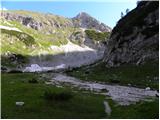 29
29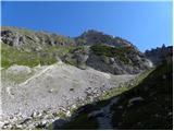 30
30 31
31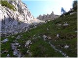 32
32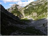 33
33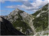 34
34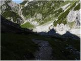 35
35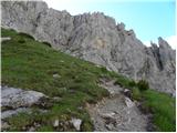 36
36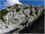 37
37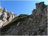 38
38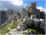 39
39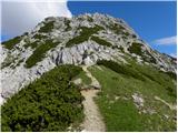 40
40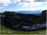 41
41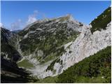 42
42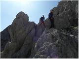 43
43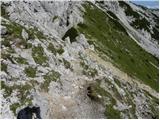 44
44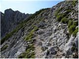 45
45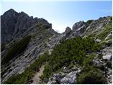 46
46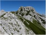 47
47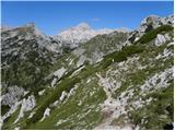 48
48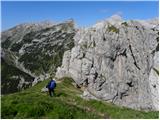 49
49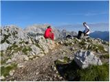 50
50
Discussion about the trip Rudno polje - Viševnik (via Jezerce and Srenjski preval)
To post a comment you must log in:
If you do not yet have a username, you must first
register.