Ruski križ - Križ (circular path through kingdom of Zlatorog)
Starting point: Ruski križ (1000 m)
Starting point Lat/Lon: 46.4444°N 13.7746°E 
Path name: circular path through kingdom of Zlatorog
Time of walking: 12 h
Difficulty: very difficult marked way
Difficulty of skiing: very demanding
Altitude difference: 1410 m
Altitude difference (by path): 2766 m
Map: Triglav 1:25.000
Access to starting point:
First, we drive to Kranjska Gora, and then we continue driving towards the mountain pass Vršič. Only a little before 3rd hairpin turn of Ruska cesta or Vršič road, we will on the right side notice Ruski križ (a cross), and on the left a smaller parking lot, where we park. Because the parking lot is relatively small and quickly full we can park also a little higher on a larger parking lot little above the 4th hairpin turn (in this case, we have to our starting point at Ruski križ descend a little).
To the starting point, we can also come from Primorska side through the mountain pass Vršič.
Path description:
From the parking lot, we continue on the road, and after few steps of walking, it brings us to Mihov dom na Vršiču.
We continue the ascent on the zig-zag road, where only few steps after the eighth turn we come to a smaller crossing, where the path branches off to the left towards Russian chapel. After a short ascent on stairs, we come to the mentioned chapel, and here we continue a little to the right, where in few steps we again step on Vršič road. We continue the ascent on the road, from which a little higher marked path towards the mountain hut Erjavčeva koča branches off to the right.
We continue right and the path already after few steps of additional walking brings us to the next crossing, where we continue on the left path (right unmarked path on Kumlehova glava and Visoki Mavrinc). A badly marked path a little higher crosses a well, and then turns to the left, where it is then for quite some time ascending through the forest. Higher, we step out of the forest, and the path only a little further brings us to the road Vršič or Ruska cesta. The mentioned road or shortcut we then follow all the way to the mountain hut Erjavčeva koča na Vršiču, which we reach after few minutes of additional walking. Behind the mountain hut, we go on the path which runs in the forest, we soon notice gully, which runs towards the north foot of Prisank. Through the gully we descend approximately 300 meters, whereupon we turn right. Past dense dwarf pines and trees we get to end of cone, which brings us to scree, on which we then go towards Hanza route on Prisank. Such a path then brings us to the entry of a climbing part of the path which is situated near the smaller waterfall.
At the entrance into a wall we continue a little right and we start ascending with the help of iron spikes and steel cables. The path then brings us to another waterfall, which we cross with the help of iron spikes. Next follows a little less demanding crossing of steep slopes towards the west. Later, the path turns to the left and it ascends past some dwarf pines. On the right side here a nice view opens up towards a little larger waterfall, which is falling over steep walls. Next follows a little steeper ascent on mostly unsecured slope, and then the path turns right into a wall and steeply ascends by numerous iron spikes and a steel cable. Next again follows a crossing of a slightly exposed slope. The path leads us past a smaller statue of Mary, which is situated left in a wall. After that, the path turns a little to the left and then follows a short descent with the help of iron spikes and steel cables, which brings us to snow field. Snow field usually lasts throughout the year, and for crossing, we urgently need an ice axe and crampons. On the other side of snow field path then turns a little right and becomes easier. We ascend on a grassy slope past some larches, and then we continue towards the west and on ledges we cross precipitous slopes. The slope then again becomes less steep and the path brings us to a crossing, which is situated at an altitude 1800 meters. To the right leads the path towards the window Prednje okno, and we continue left on the path Hanzova pot.
After a short undemanding ascent we then quite few times steeply ascend by the steel cable with the help of numerous iron spikes. The path then brings us on quite gentle slopes on the south side of the peak Hanzov Turn (2040 meters). Here is usually one more snow field, which is less steep than the first one.
We continue slightly right below the steep walls of Prisojnik and then we ascend through a slightly crumbly gravel gully towards the notch on the south side of the peak Hudičev steber (2237 meters). Here is before the entrance in very demanding part of the path also inscription book. The path further almost vertically ascends with the help of steel cables and iron spikes, after that on ledges crosses precipitous slopes towards the west. Later, the path turns to the left and starts ascending on quite steep northern slopes upwards. This part of the path mostly isn't secured therefore a little more caution is needed. The path then turns to the left and on less a steep slope it brings us on northeast side of the peak. Here the path again becomes very demanding and at first vertically ascends on stemples and then also on a slightly exposed slope with the help of steel cables and iron spikes. From here follows only a short ascent to the top Prisojnik.
The path Hanzova pot on Prisojnik is the longest secured climbing path in Slovenia and also technically belongs among most difficult. Because of snow fields on the path, there is also in the summer time mandatory to use ice axe and crampons.
From the top Prisojnik we descend on a marked path Jubilejna pot, which runs through the window Zadnje okno. We walk on very exposed path, therefore it is also recommended to use a self-belay set and a helmet (mainly in Okno!). We leave the path little after the notch between Prisank and Razor (1995 meters). The path then crosses slopes below Razor and only a little further brings us to the entrance in technically more demanding part of the path. With the help of fixed safety gear we ascend on short wall, which doesn't cause bigger problems. The path then goes towards the south and tower Utrujeni stolp. We are soon on a saddle Planja, where joins the path from Pogačnikov dom. Here we go left (right Planja) and we continue the ascent on the path which is nicely routed on natural passages (in some parts slightly exposed). Higher, we notice cave in which almost over all year stay snow and ice. The path is then slowly turning to the left and we soon walk on an exposed ledge. The path then turns right on the other side of the ridge. Next follows only few steps of easy climbing and we are on the summit.
From Razor we descend on Kriški podi, we can turn from the path five minutes away and have a snack in mountain hut Pogačnikov dom na Kriških podih (2050 meters.n.meters.), or we continue ahead towards Križ (2410 meters).
From the mountain hut Pogačnikov dom we continue in the direction of Razor and Križ on the path which slightly descends and in few steps, it brings us to the next crossing, where we go right (left Razor). Further, we are ascending on at first gentle, after that on a little steeper path which leads us over karst terrain of Kriški podi. A little higher to the right (or straight) path which leads towards Zgornje Kriško jezero branches off, and we continue straight (or left) on the path which higher crosses steep slopes of Kriški rob. When the path at the end of the crossing of Kriški rob brings us on a ridge, we have a nice view towards 2382 meters high Šplevta (mountain with shape of Indian). Further, the path steeply ascends on rugged rocks (dangerous for slipping) and higher brings us on Bovška vratica. We continue right towards the summit of Križ (straight Škrlatica, Dolkova špica, Krnica and Bivak na Rušju), to which we only have 10 minutes of walking. The path ahead is at first ascending gently on a narrower ridge and then with the help of steel cables steeply ascends over a slightly exposed rocky plate, after which we come to an interesting passage through a natural groove. With some skills, through a narrow groove, we ascend on panoramic Križ.
From Križ we descend towards Vrh Kriške stene (2289 meters) and on a secured mountain path towards Krnica. From Krnica then follows only easy walk back to 3th zig zag. With that is our circle completed.
On this path we made around 2800 altitude meters. Because of snow field it is good to walk the path in late summer. It will require good physical condition, good psychic condition and working camera. For many this won't be possible in one day. (Option of sleeping at Kriški podi). For all who will go on this circular path, immense beauty of Julian Alps is awaiting, gloomy northern mountain wall of Prisank, and pastures and karst terrain of Kriški podi. For those, who want to take really maximum they can extend the trip also on near Stenar (2501 meters). From Križ hour of walking.
Time of walking: 3th zig zag road - Prisank (Hanza) 5 hours, Prisank - saddle Planja 2 hours, Planja - Razor 1 hour, Razor - Kriški podi 45 minutes, Kriški podi - Križ 1.5 hours, Križ - Vrh Kriške stene 10 minutes, Stena - Krnica 1.5 hours, Krnica - starting point 30 minutes.
Times are only informative and don't include rests on the path which will certainly occur.
On the way: Mihov dom na Vršiču mountain hut (1085m),
Ruska kapelica (1130m),
Erjavčeva koča na Vršiču mountain hut (1525m),
Prisank / Prisojnik (2547m), Zadnje okno (2200m), Sedlo Planja (2349m),
Razor (2601m), Sedlo Planja (2349m),
Pogačnikov dom na Kriških podih mountain hut (2050m), Bovška vratica (2375m),
Križ (2410m), Bovška vratica (2375m), Vrh Kriške stene (2289m),
Koča v Krnici mountain hut (1113m) Trip can be extended to: Stenar
Pictures:
 1
1 2
2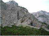 3
3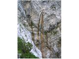 4
4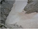 5
5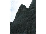 6
6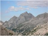 7
7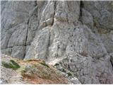 8
8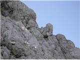 9
9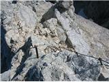 10
10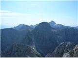 11
11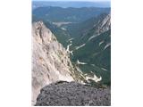 12
12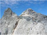 13
13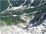 14
14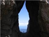 15
15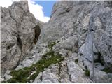 16
16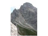 17
17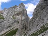 18
18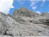 19
19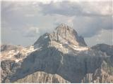 20
20 21
21 22
22 23
23 24
24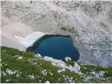 25
25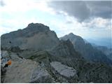 26
26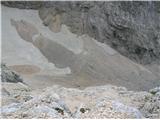 27
27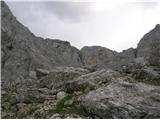 28
28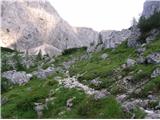 29
29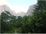 30
30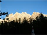 31
31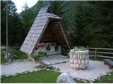 32
32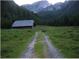 33
33