Salzstiegelhaus - Peterer Riegel
Starting point: Salzstiegelhaus (1543 m)
| Latitude/Longitude: | 47,06818°N 14,87182°E |
| |
Walking time: 1 h 45 min
Difficulty: easy marked way
Elevation gain: 424 m
Elevation difference along the route: 525 m
Map:
Recommended equipment (summer):
Recommended equipment (winter): ice axe, crampons
Views: 148
 | 1 person like this post |
Access to starting point:
We leave the Highway A2 Klagenfurt - Graz at the exit Packsattel, and then we follow the signs for Graz and Pack. At the settlement Stampf we leave the old road towards Graz and continue driving in the direction of the settlement Hirschegg, and from there we follow the signs for the ski slope Salzstiegel and the mountain hut Salzstiegelhaus. In the last part, we follow the macadam road to the parking lot at the mountain hut Salzstiegelhaus, which is situated by the mountain pass Hirscheggersattel.
b) We leave the Highway A2 Graz - Klagenfurt at the exit Modriach, and then we follow the signs for the lake Packer Stausee and the settlement Hirschegg. From the settlement Hirschegg we follow the signs for the ski slope Salzstiegel and the mountain hut Salzstiegelhaus. In the last part, we follow the macadam road to the parking lot at the mountain hut Salzstiegelhaus, which is situated by the mountain pass Hirscheggersattel.
Route description:
Signposts at the mountain hut Salzstiegelhaus direct us left towards the southwest in the direction of the saddle Peterer Sattel and the peaks Speikkogel, Ameringkogel, and Großerberg, where we initially walk on a macadam road, then quickly turn right onto a cart track. The cart track we follow moderately ascends, and at the crossing of the grazing fence, we turn left towards Ameringkogel. There follows some easy walking, then we moderately ascend on a grassy slope where a ski slope runs in winter. When the forest along the path ends, we quickly ascend to the indistinct peak Rosseben, where the artificial lake Salzstiegel Almsee is nearby.
We bypass the lake on the left side, then in a gentle ascent, we reach a marked junction.
From the junction, we continue slightly left in the direction of the saddle Peterer Sattel (slightly right Speikkogel and Ameringkogel) and start descending diagonally. After some time, the path flattens, crosses a stream, and then passes into a strip of forest, where we gradually start ascending diagonally. When we leave the forest, some more traversing follows, and in the final part of a gentle ascent, we reach the junction at Peterer Sattel.
Here we head onto the path towards Peterer Riegel (slightly left towards Pack, slightly right towards Peterer Hütte – the path that bypasses the summit of Peterer Riegel, right towards Weißensteinhütte) and begin ascending alongside a wire fence. A somewhat steeper and increasingly panoramic ascent follows, and we stick to this path all the way to the cross on the summit.
Starting point – Rosseben 0:30, Rosseben – Peterer Sattel 0:40, Peterer Sattel – Peterer Riegel 0:35.
Description and photographs refer to conditions in July 2023 and October 2025.

Photos:
 1
1 2
2 3
3 4
4 5
5 6
6 7
7 8
8 9
9 10
10 11
11 12
12 13
13 14
14 15
15 16
16 17
17 18
18 19
19 20
20 21
21 22
22 23
23 24
24 25
25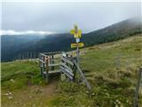 26
26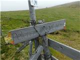 27
27 28
28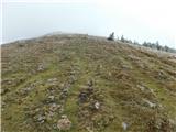 29
29 30
30 31
31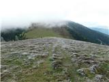 32
32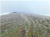 33
33 34
34 35
35 36
36 37
37 38
38 39
39 40
40 41
41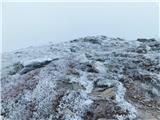 42
42 43
43
Discussion about the trip Salzstiegelhaus - Peterer Riegel
To post a comment you must log in:
If you do not yet have a username, you must first
register.