Schwarzkogelhütte - Hohenwart
Starting point: Schwarzkogelhütte (1558 m)
| Latitude/Longitude: | 46,94523°N 14,69840°E |
| |
Walking time: 50 min
Difficulty: easy marked way
Elevation gain: 260 m
Elevation difference along the route: 270 m
Map:
Recommended equipment (summer):
Recommended equipment (winter): ice axe, crampons
Views: 95
 | 1 person like this post |
Access to starting point:
a) Over the Ljubelj border crossing we drive into Austria and follow the signs for Klagenfurt am Wörthersee. In Klagenfurt at McDonald's we go right onto the south bypass / Südring, at the next major intersection we go right again towards Völkermarkt / Velikovec and Brückl / Mostič. We soon leave the road to Völkermarkt, shortly after the Obi store turning right towards the highway and Mostič. We then pass the Ikea store, following the signs for Mostič and past the highway on-ramps. When we arrive in Mostič we follow the signs for Eberstein / Svinec and Hüttenberg. Still before Hüttenberg, more precisely behind the settlement Mösel, we turn right towards the Klippitztörl pass and the settlement Lölling. We then begin to ascend more noticeably along the valley of the Löllingbach stream, higher up, behind the settlement Lölling, gradually distancing ourselves from the stream as well. We follow this road all the way to the Klippitztörl pass, from where we begin to descend. During the descent the road takes us past the Naturfreundehaus hut, but we descend to the Klippitztörl settlement, where we go left uphill towards the Hohenwarthütte hut. A short ascent and a left serpentine follow, and we arrive at a large parking lot located next to the ski area and the aforementioned hut.
b) Over the Jezerski Vrh, Holmec or Vič border crossings we drive into Austria, then follow the signs for Völkermarkt / Velikovec, from there the signs for Brückl / Mostič. When we arrive in Mostič we follow the signs for Eberstein / Svinec and Hüttenberg. Still before Hüttenberg, more precisely behind the settlement Mösel, we turn right towards the Klippitztörl pass and the settlement Lölling. We then begin to ascend more noticeably along the valley of the Löllingbach stream, higher up, behind the settlement Lölling, gradually distancing ourselves from the stream as well. We follow this road all the way to the Klippitztörl pass, from where we begin to descend. During the descent the road takes us past the Naturfreundehaus hut, but we descend to the Klippitztörl settlement, where we go left uphill towards the Hohenwarthütte hut. A short ascent and a left serpentine follow, and we arrive at a large parking lot located next to the ski area and the aforementioned hut.
c) We leave the Klagenfurt am Wörthersee - Graz motorway at the Šentlenart exit in the Labotska dolina / Bad St. Leonhard im Lavanttal, then follow the signs for Zeltweg and Reichenfels. We then drive along Obdacher Straße, which after about 2 km we leave, continuing left towards the Klippitztörl pass. A climb follows along the ascending asphalt road, which we follow to the Klippitztörl settlement, where we turn sharply right towards the Hohenwarthütte hut. A short ascent and a left serpentine follow, and we arrive at a large parking lot located next to the ski area and the aforementioned hut.
Route description:
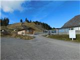
From the hut we head onto the road, alongside which there are signs for the Hohenwart peak and the Hohenwarthütte hut, initially ascending moderately past a few more holiday homes. A little further, we leave the road slightly to the right and climb the grassy slope, soon approaching the road completely again, but we do not continue along it, instead ascending to the right of the road. Higher up, the path leads through a strip of forest; once we leave the forest we descend briefly a little, where we approach the road completely again. A few minutes of steeper ascent along the ski slope route follow, then we return to the road, which we follow to the Hohenwarthütte hut. We bypass the hut on the left side and ascend along the road to a broader ridge along which we continue to a junction by the reservoir lake.
We continue right towards the Hohenwart peak (left to the Klippitztörl pass, straight to Zirbitzkogel), which we reach after a few minutes of increasingly scenic walking.
Schwarzkogelhütte - Hohenwarthütte 0:30, Hohenwarthütte - Hohenwart 0:20.
Description and photographs refer to conditions in November 2025.

Photos:
 1
1 2
2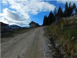 3
3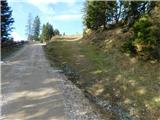 4
4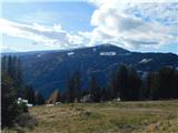 5
5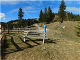 6
6 7
7 8
8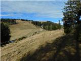 9
9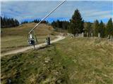 10
10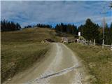 11
11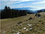 12
12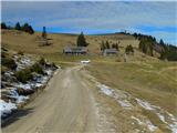 13
13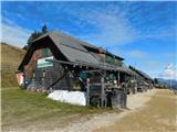 14
14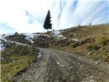 15
15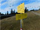 16
16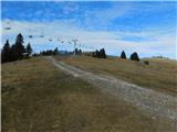 17
17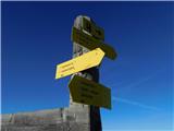 18
18 19
19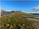 20
20 21
21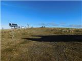 22
22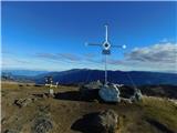 23
23
Discussion about the trip Schwarzkogelhütte - Hohenwart
To post a comment you must log in:
If you do not yet have a username, you must first
register.