Selo pri Žirovnici - Sveti Lovrenc above Zabreznica
Starting point: Selo pri Žirovnici (545 m)
Walking time: 30 min
Difficulty: easy unmarked way
Elevation gain: 180 m
Elevation difference along the route: 180 m
Map: Karavanke - osrednji del 1 : 50.000
Recommended equipment (summer):
Recommended equipment (winter): crampons
Views: 15.673
 | 3 people like this post |
Access to starting point:
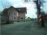
From the Ljubljana-Jesenice highway, we take the Lesce exit, where at the roundabout we turn onto the old road in the direction of Žirovnica and Jesenice. After a few kilometers of driving, we arrive at the intersection in Žirovnica, where we turn right, and already after a few meters again right over the railway in the direction of east. When we drive through the village Žirovnica, we encounter the place sign - Selo pri Žirovnici. We park at a suitable place nearby.
Route description:
Just a few meters ahead from the place sign, at the slight right bend (a little before the inn Osvald), at the somewhat larger building with pink facade, we turn left from the road into the street, which winds its way up among the houses. At the first intersection we turn left, soon after that at the second right, where we also encounter a wooden signpost "Sv Lovrenc". When the asphalt ends, after some 10 m at the fork before the residential building we turn left onto the cart track uphill, where we soon encounter a pasture fence with a gate and inscription "Sv Lovrenc". We continue on the cart track of the pasture (left shortcuts), which after some 10 m turns left, later somewhat higher (on the right a shortcut branches off), then right past the church landmark under the edge of the forest, where it turns even a little more to the right in the direction of east. When we encounter a wooden hut, the path soon turns left into the forest, where we walk on steps along a wooden fence. After a few minutes' walk along this fence (higher - right another shortcut branch-off), we encounter the last wooden signpost, where we continue straight (left uphill Brinjev vrh), and after some 10 m of further walking through the forest we arrive at the church of Sv. Lovrenc.
The logbook is located under the wish bell in front of the church entrance.

Photos:
 1
1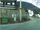 2
2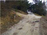 3
3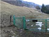 4
4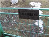 5
5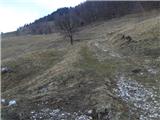 6
6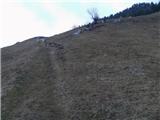 7
7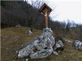 8
8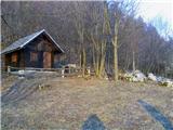 9
9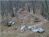 10
10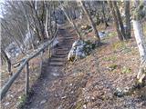 11
11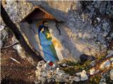 12
12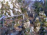 13
13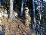 14
14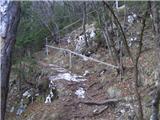 15
15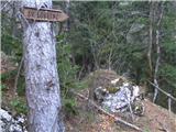 16
16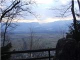 17
17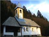 18
18 19
19
Discussion about the trip Selo pri Žirovnici - Sveti Lovrenc above Zabreznica
|
| megalodon23. 03. 2011 |
Hello,
I need a bit of help. I'm interested in where the path from Selo pri Žirovnici to Završnica goes (allegedly through a tunnel).
Is it suitable for children. We were at sv. Lovrenc 14 days ago, does the path branch off a bit below the cross on the meadow. What's the timing of the path (of course dawdling because of children). Maybe someone will muster up and even publish it under the path descriptions.
Thanks for any information.
|
|
|
|
| heinz23. 03. 2011 |
The simplest way is to head to the water tank in Žirovnica. There are stairs leading to it, then we come across a (even marked) path to the left, which quickly takes us to the little tunnel. From there on, we're in Završnica in about 20 min.
|
|
|
|
| heinz23. 03. 2011 |
That's right: the path is absolutely suitable for children (with accompaniment)
|
|
|
|
| megalodon23. 03. 2011 |
Don't mind if I burden you a bit more. 
But can't it be done from the path to sv. Lovrenc? And where in Žirovnica do you go to the water tank? Thanks.
|
|
|
|
| klm24. 03. 2011 |
Past the Trebušnik inn, then constantly along the main branch of the asphalted road through the village uphill, to the last house where there is a horse fence on the left. Through it (don't forget to close it behind you!), then across the meadow and very steep stairs to the water tank. From there wherever you want. There are as many paths as there are options, or vice versa.
|
|
|
|
| heinz24. 03. 2011 |
Probably yes. But from the ridge crest you probably don't get directly to the water tank from the right. So try from near the cross downwards across the meadow (possible path variants upwards lead to the top of the ridge) all the way below the water tank. Otherwise, in this direction partly leads a branch of the road in the middle of Žirovnica (past the Trebušnik inn), then left under the ridge to the foot of the water tank.
Check the map on Geopedia.si - Hiking.
With a small dose of exploratory spirit, the whole thing will be quite simple for you.
Best regards!
|
|
|
|
| heinz24. 03. 2011 |
klm: you beat me to it..
|
|
|
|
| Majdag27. 01. 2024 19:59:22 |
25.1... Started a bit off from Vodostan. It's a nice path through meadows. There's not much snow and you can avoid walking in it. Daisies are already peeking out of the ground and there are quite a few chicks. Spring was felt in the air and it was warm. Sitting on the bench by the little church and enjoying the wonderful landscape brightens the day..
https://jelenkamenmajdag.blogspot.com/2024/01/sveti-lovrenc-nad-zabreznico.html
|
|
|
To post a comment you must log in:
If you do not yet have a username, you must first
register.