Starting point: Senožeče (560 m)
| Latitude/Longitude: | 45,72100°N 14,03950°E |
| |
Walking time: 1 h 45 min
Difficulty: easy marked way
Elevation gain: 467 m
Elevation difference along the route: 500 m
Map:
Recommended equipment (summer):
Recommended equipment (winter):
Views: 145.577
 | 10 people like this post |
Access to starting point:
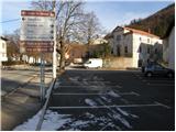
From the highway Ljubljana - Koper we go to the exit Senožeče. When we leave the highway, at the first crossroad we continue left in the direction of Senožeče. In Senožeče, we turn left in the direction of Razdrto and we follow the road only 100 meters to the parking lot in Senožeče, which is situated by the main road. The right parking lot is the one by which we notice signposts for Vremščica.
Route description:
From the parking lot, we continue on the road in the direction of Vremščica. The road which leads us among houses soon brings us to a smaller memorial park, where we come to the next mountain signposts. Here we continue on the left road which takes us past the last houses in the village and brings us to fenced pastures. The road which is getting worse here splits into two parts. We continue on the lower one in the direction of Vremščica, which soon changes into a cart track. A little further, the cart track brings us into a dense forest, where the path continues through a small valley. The path through the forest gradually starts to ascend more and more and eventually brings us to the unvegetated slopes of Slatna 914m. The path ahead starts slightly descending and soon brings us into a short strip of forest which we quickly leave. The path ahead brings us to a frost hollow, which is situated on the north side of the main ridge of Vremščica. Here the signpost by the path tells us that to the top we have 30 more minutes of walking. The path ahead goes into the forest and starts to ascend more steeply. In the upper part of the forest, we join a wide cart track which we follow to the left. The cart track in the next few steps brings us to a crossing, where we continue left in the direction of Vremščica. The path ahead gradually transitions onto more panoramic upper slopes of Vremščica. This path which leads us along the wide upper ridge of Vremščica we follow all the way to the top, which we reach in a few minutes.

Photos:
 1
1 2
2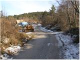 3
3 4
4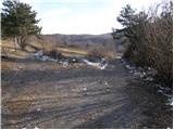 5
5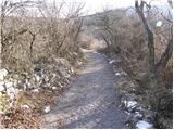 6
6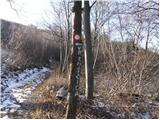 7
7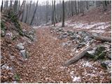 8
8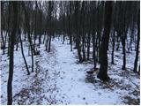 9
9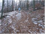 10
10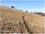 11
11 12
12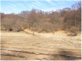 13
13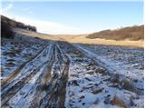 14
14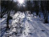 15
15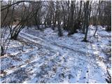 16
16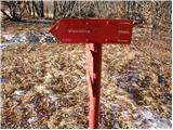 17
17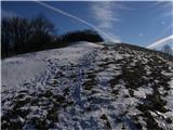 18
18 19
19
Discussion about the trip Senožeče - Vremščica
|
| Gost3. 01. 2008 |
Nice trip in all seasons, most beautiful in spring when Vremščica turns into a botanical garden. Narcissuses are also noticeable, which to me personally are even prettier than those on Golica.
|
|
|
|
| jerry12. 05. 2008 |
Really nice! Easy path, but varied. Due to fewer people much quieter than Slavnik, Sneznik, Slivnica... Too bad there's no hut on the path or summit!
|
|
|
|
| ervinplaninec1. 02. 2009 |
I have a question, do you think that a trip to Vremščica in March is suitable
|
|
|
|
| Tadej1. 02. 2009 |
A trip to Vremščica is suitable at all times of the year, just make sure not to choose a day with strong bora wind.
|
|
|
|
| Karletto6. 02. 2010 |
In snow and ice the markers around Slatna are poor. Wind and snow cover the tracks of previous hikers and you just have to continue 'blindly'. (!)
|
|
|
|
| marbrz3. 09. 2010 |
Where can I get the stamp for the Tranzverzala?
|
|
|
|
| klavdipo3. 09. 2010 |
At the top it's embedded in a pillar. Just bring the ink pad with you! LP
|
|
|
|
| K&R5. 04. 2011 |
When do the daffodils grow there??
|
|
|
|
| GITA5. 04. 2011 |
I went to look at the photo albums... I have photos from May 10th two years ago... but I remember they were already a bit towards the end... so, if a week earlier, it would have been even nicer...
|
|
|
|
| K&R6. 04. 2011 |
Thanks
|
|
|
|
| Kokta11. 12. 2011 |
Nice and easy path, recommend visiting in good weather....unfortunately quite foggy today, but still nice
|
|
|
|
| Darxta15. 07. 2012 |
Still a nice path, well marked, great view... recommend!
|
|
|
|
| anival3. 10. 2013 |
Very nice path. Beautiful landscape. The summit logbook has been completely full for a few days  . Otherwise super . Otherwise super
|
|
|
|
| crtomeister14. 04. 2014 |
Currently access to Vremščica on the mentioned path is closed due to glaze ice damage. There is a lot of fallen and uprooted trees and at some places passage on the marked path is impossible.
|
|
|
|
| zabava24. 09. 2014 |
I'm planning to go to Vremščica this weekend. TV is talking a lot about bears and wolves in the Karst. I'm interested if it's really possible to encounter such a beast.
|
|
|
|
| tine.sl24. 09. 2014 |
But this weekend such beasts will surely avoid Vremščica, because there's such a crowd there that there's no room for them at all
|
|
|
|
| ajax24. 09. 2014 |
hahaha, this weekend? nonsense :eek
|
|
|
|
| zabava27. 09. 2014 |
hahaha. thanks a lot for the answers. Here the bears have counted all the hikers, so during the week we only occasionally meet them, but on weekends we really scare them away, because there are more hikers than bears, and they are afraid of us. Already looking forward to the walk to Vremščica
|
|
|
|
| VikaT31. 10. 2014 |
Today we were on Vremščica. The path was easier than I expected. The weather was really wonderfully sunny, a bit windy, but no panic. Great hike on the last October day.
|
|
|
|
| ribnik8. 03. 2015 |
Wonderful day, though with some gusts of wind and a surprise at the end by the chapel. Thanks to the finder of the black glove for picking it up and placing it in a visible spot.
|
|
|
|
| korab4. 01. 2017 |
Yesterday we were on Vremščica for the first time via this path. We've set off up from the Pivka side several times, as Vremščica is always the right choice. Wind was strong, but the view and solitude make up for everything.
The path is cleared and very well marked.
|
|
|
|
| modrook1215. 04. 2018 |
Today on this path to Vremščica. Fallen trees in some places, but nothing particularly annoying. Otherwise nice path, without special features and well marked.
|
|
|
|
| suzys17. 05. 2020 |
How are the narcissi and other flowers at this time. And which path do you recommend that's richer in flowers? Thanks
|
|
|
|
| darinka428. 12. 2020 |
Yesterday I went from Senožeče to Vremščica. Now the path is known to me. And marked. So you won't get lost. Not difficult at all. Although there was snow, there were no problems walking. It was just cold and quite windy from the frost hollow to the top. Quite a few hikers considering the cold day and snow. Also on the descent in that steep part, nothing slipped. Maybe because it was in the forest. And the day was sunny and nice.
|
|
|
To post a comment you must log in:
If you do not yet have a username, you must first
register.