Serdica - Beli breg (via Rožičev breg)
Starting point: Serdica (239 m)
| Latitude/Longitude: | 46,81596°N 16,02702°E |
| |
Route name: via Rožičev breg
Walking time: 35 min
Difficulty: easy unmarked way
Elevation gain: 107 m
Elevation difference along the route: 113 m
Map: Pomurje 1:40.000
Recommended equipment (summer):
Recommended equipment (winter):
Views: 135
 | 1 person like this post |
Access to starting point:
We drive to Gederovci (from Murska Sobota or Radenci to here), and then we continue driving towards Kuzma. After Rogašovci we arrive in Nuskovo, and a little further already in Serdica, where signs for Serdiški breg and Ocinje direct us left onto a side road. We park after the junction at a suitable place beside the road.
Route description:
At the starting point, we notice signs for Serdiški breg, which direct us onto the side road beside which we have parked. Serdica ends immediately, and we quickly reach the fire station, behind which the path from Nuskovo joins from the left.
We continue straight ahead, at the next junction going slightly left (right: Serdiški breg via Brunarjev breg).
The path ahead begins to ascend along the asphalt road, leading us past a few houses. Higher up we reach a small saddle, where the marked path to Serdiški breg turns right, while we continue left past the NOB monument. The path ahead leads along a wide ridge; behind the last house the asphalt ends and we reach the indistinct Rožičev breg, followed by a gentle short descent. There follows a walk along an increasingly panoramic macadam road, which we follow all the way to the grassy Beli breg.
Description and pictures refer to the situation in March and August 2021.
Along the route: Rožičev breg (327m)
Photos:
 1
1 2
2 3
3 4
4 5
5 6
6 7
7 8
8 9
9 10
10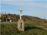 11
11 12
12 13
13 14
14 15
15 16
16 17
17 18
18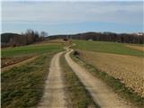 19
19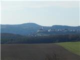 20
20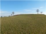 21
21 22
22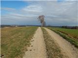 23
23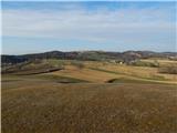 24
24
Discussion about the trip Serdica - Beli breg (via Rožičev breg)
To post a comment you must log in:
If you do not yet have a username, you must first
register.