Sežana - Veliki Medvejk / Monte Orsario (via the Karst living museum, Orlek and Fernetiči)
Starting point: Sežana (353 m)
Starting point Lat/Lon: 45.69894°N 13.87028°E 
Path name: via the Karst living museum, Orlek and Fernetiči
Time of walking: 2 h 30 min
Difficulty: easy marked way
Difficulty of skiing: no data
Altitude difference: 119 m
Altitude difference (by path): 119 m
Map: Poti so zadovoljivo vrisane na OpenStreetMap in v aplikaciji maPZS
Access to starting point:
With a car: We leave the highway between the junction Gabrk pri Divači and the border crossing Fernetiči at exit Sežana-vzhod (first after the before mentioned junction). From the exit we turn left, i.e. direction Sežana. Soon after the exit follows a traffic light crossroad, where from the right joins regional road from Nova Gorica, and from the left a local road from Divača. We continue straight and immediately after that crossroad we get to Sežana. At the next traffic light crossroad we turn left on the road Bazoviška cesta (signpost towards Lipica). On overpass we cross a railway track, immediately and then at the roundabout we turn right, and at the next roundabout we go straight (direction ZGRS Sežana or the Karst living museum). A little further from the fire station, where the asphalt ends and the traffic sign prohibits further driving to all except landowners, on the right we notice a free parking lot, where we can park. We can also park earlier somewhere in the center of Sežana, but during the week the parking there is time-limited and/or payable.
With a train: near the railway station Sežana unfortunately there aren't any settled passage over the track, therefore on the street Kosovelova ulica we go towards the east all the way to the end and then we turn right on the road Bazoviška cesta. On an overpass we cross the railway track, and then immediately at the roundabout we go right, and at the next roundabout we go straight (direction ZGRS Sežana or the Karst living museum). Little further from the fire station the asphalt ends, and on the right side we notice a parking lot, which serves as the starting point of the path.
Path description:
Caution: the path leads through the territory of Italy, where we come to on a remote cart track, therefore before the trip we need to find out if the Schengen regime is frozen and crossing the border outside the official border crossings isn't allowed. Mandatory we need valid identity document, if we happen to come across patrols looking for illegal migrants in remote areas.
Slovenian part of the route coincides with the official mountain path of Sonja Mašera, which otherwise leads from Sežana to Trst, but by the path, we will barely find any PZS trail blaze. But the Karst living museum (further KLM) very well-marked the path all the way to Orlek. From the starting point at the parking lot we go on a wide macadam road towards the south (KLM trail blaze towards Bazovica). By the path at numerous crossings KLM trail blazes point us towards numerous attractions a little away from the main path, which can be viewed if desired. Take into account that the attractions in average are about 1 km away from the main path, so that the sightseeing adds quite a bit to the distance of the trip. If we are not interested in these attractions, we stick to a macadam road towards Bazovica. After about 2 km we reach the crossing, where signs of KLM and also red signpost of PZS point us to the right towards Orlek's gunpowder factory and the village Orlek. So here we turn right on a little narrower forest road. Soon the path brings us between two columns, which are left from the former Orlek's gunpowder factory from the time between the both world wars. A little further follow two more columns, where we leave the area of gunpowder factory. From here further there are several possible paths towards Orlek, which is otherwise well-marked with KLM trail blazes. If we are not interested in specific attractions, at every crossing, where there more paths are available towards Orlek, everytime we choose the right variant, which is also the shortest. In this case the path after about 2 km past the pond brings us to Orlek, where KLM trail blazes end.
When we in Orlek again reach the asphalt, there are two possible paths to NOB monument on the other end of the village. On the official variant here we turn right and immediately after this left. And if we are interested in cultural heritage, at the end of the macadam we at first turn left. But here the asphalt road immediately splits into several paths, we choose the most right of them, which soon brings us to the chapel, where we follow the white arrow on the wall and we turn right. Through the village we soon reach another crossing with a stone cross in the middle, here we turn left and we soon reach a smaller "square" with the NOB monument on the northern edge.
From the recycling spot on that "square" we continue towards the west and we soon reach another crossing. Straight leads access path on a fenced private land. The official route leads left on an asphalt road all the way to the border. If we decide for this one, immediately after the border we turn right and we follow Italian signs, which bring us to Fernetiči. I recommend, that here we go right on a cart track, because the path to Fernetiči is a little shorter, and at the same time we gain also an option to view Orleška draga. If we decide for this option, this section unmarked and it is good to know some pointers for navigating the turn-offs. On the cart track, we at first all the time stick straight, until we get to a narrow underpass under the railway track between Sežana and Opčine. Immediately after the underpass follows a crossing of several paths. We continue on the most right, where also the cart track is the best. From here we walk about 250 meters, when follows another crossing. "Straight" (or "more right") leads our main path towards the border, if we want to view also the karst valley Orleška draga, circled with magnificent vertical walls, we can go here left. The cart track lightly brings us on the bottom of the karst sinkhole about 60 altitude meters lower. Walking itself to the bottom of the karst sinkhole and back takes about 20 minutes.
From the crossing towards Orleška draga we continue "right"/straight and after about 200 meters we reach the national border, which is from Slovenian side "invisible", only few meters after the border line on the Italian side we notice a large sign, which from the opposite direction warns about the proximity of the border. At this sign from the left joins also the official path, if in Orlek we would continue on the asphalt road and then already on the Italian side on the west side bypassed Orleška draga. From here further Italian trail blazes will guide us, mostly white and red stripes similar to the Polish flag, and occasionally also similar to the Austrian flag red - white - red with number of the path. Soon after the border line we reach a highway and we cross it through an underpass and we reach the first house in Fernetiči. A little further, we reach a quite busy main road border crossing Fernetiči - Opčine - Trst, where we turn right. Here starts the least pleasant part of the path, because by roads there basically aren't any sidewalks. First few meters we walk on the right side of the road, and when on the opposite side appears enough space by the road, we carefully cross the road (there aren't any marked pedestrian crossing). After additional 200 meters we reach the crossroad, where we turn left towards Repentabor (italian Monrupino). We at first walk on the left side of the road, because on the right there is very busy junction on Italian highway. On the overpass we cross truck terminal and by the road (which luckily isn't very busy) we continue towards Repentabor. About 400 meters from the overpass follows a mild left turn, and immediately after it on the right follows a smaller roadside parking lot, which serves as the starting point of the path on Veliki Medvejk. If we haven't done it before, here we very carefully cross the road (the turn isn't well visible!) and on that "parking lot" we look for a footpath which starts with the sign prohibiting traffic, and the pole is circled with Italian red white red trail blaze.
Here ends the flat part of the path and starts mountain part with a moderate ascent. If until now we have indulged ourselves with walking on the mostly well-passable cart tracks, now almost to the top there is mostly a narrow and not very beaten footpath, sometimes it runs also on rocks, and in normal tempo we will in around 30-45 minutes overcome about 150 altitude meters. But the official path is well marked, "polish flags" are on rocks or trees literally on every few meters, at the crossings the lines are curved and thus clearly show where we should turn.
When the path number 3 brings us already quite high on about 441 meters, follows another crossing and next to a fallen tree with red - white- red trail blaze. If we would continue here on the official path towards "left", we would soon reach the forest road, where we would turn right and on the path number 43 reach the peak. We can also choose a shortcut, and at that crossing we turn right and on a similar footpath until now (but unmarked) we soon reach the mentioned road a little higher. On a little steeper "stairs" we ascend to this road and we turn right, i.e. upwards. The road immediately makes a sharp left turn and turns for a little less than 180°. After barely 100 meters after that turn, at the spot, where on the left side we can notice ruins of some house, follows the last important crossing. Blazes for path number 43 point us to the right on a quite steep footpath across the "scree", which soon on Italian territory brings us directly to panoramic platform. If we are no longer in the mood for this ascent, we can continue straight on the forest road which few meters later enters the Slovenian territory and there gently brings us to the top.
If we don't want to go back the same way, we can in Sežana return on unmarked shortcut, where it is very recommended to have navigation with a sufficiently detailed map (OpenStreetMap is also sufficient). From the top, we go on the before mentioned forest road on the Slovenian territory. On two spots to the right (i.e. downwards) footpaths branch off which soon join into a still poorly beaten footpath. If we don't get lost, we eventually reach the macadam forest road which connects Sežana and Vrhovlje. In any direction we're going, we still have quite a walk to reach the first signs of "civilization". In addition, finding a suitable place to cross the highway near Sežana can turn out to be a bit more difficult.
Description and pictures describe the condition in November 2022.
Pictures:
 1
1 2
2 3
3 4
4 5
5 6
6 7
7 8
8 9
9 10
10 11
11 12
12 13
13 14
14 15
15 16
16 17
17 18
18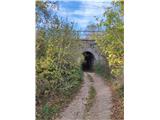 19
19 20
20 21
21 22
22 23
23 24
24 25
25 26
26 27
27 28
28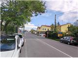 29
29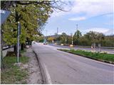 30
30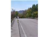 31
31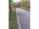 32
32 33
33 34
34 35
35 36
36 37
37 38
38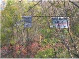 39
39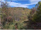 40
40 41
41 42
42 43
43 44
44 45
45 46
46 47
47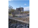 48
48