Slovenji Plajberk / Windisch Bleiberg - Kosmatica / Kosmatitza
Starting point: Slovenji Plajberk / Windisch Bleiberg (948 m)
| Latitude/Longitude: | 46,49020°N 14,23930°E |
| |
Walking time: 3 h
Difficulty: easy unmarked way
Elevation gain: 711 m
Elevation difference along the route: 740 m
Map: Karavanke - osrednji del 1:50.000
Recommended equipment (summer):
Recommended equipment (winter): ice axe, crampons
Views: 850
 | 2 people like this post |
Access to starting point:
Over the Ljubelj border crossing we drive into Austria, and after a few kilometres we turn left towards the valley Poden / Bodental. There follows some more ascent, and then we arrive at the settlement Slovenji Plajberk / Windisch Bleiberg, where we park on the parking lot below the church.
Route description:
From the parking lot below the church we continue straight and quickly arrive at the inn Gasthaus Kirchenwirt in Windisch Bleiberg, where before the inn to the right branches off the marked path to Žingarica / Singerberg, after the inn and still before the end of the settlement to the left branches off the marked path towards the valley Poden / Bodental.
We continue left, cross the bridge and ascend to the nearby chapel. At the chapel we continue straight (also sharply right possible, in this case higher for a short time we walk on the asphalt road) and go past a few houses to the nearby hayrack, where we leave the road.
We continue right, where on a nearby tree we notice the marking of path 17. The path ahead leads us along the edge of the forest, higher also through a strip of forest, then along the edge of the pasture to the asphalt road, which we reach at the chapel. We cross the road to the right (left settlement Žabnica / Bodental) and continue in the direction "Bodental, Sonnenhang 15 min.".
Follows a traverse ascent through a strip of forest, we walk on path no. 2. Somewhat further the forest ends and with nice views on the central Karawanks we reach the pension Lužekar / BergPension Lausegger.
We continue along the road, where the path leads us past the "exhibition" and farm, along the asphalt road we descend to the marked crossroads, from which we continue slightly right onto the macadam road in the direction of Vgrizeva planina / Ogrisalm and Celovška koča / Klagenfurter Hütte. A little further from the left joins one of the paths from the inn Gasthof Sereinig, after the junction we arrive at some houses in the settlement Žabnica, where at the first crossroads we go left, at the second right in the direction of Vgrizeva planina and Celovška koča. The path ahead also leads past the chapel, behind which markings of path 603 appear, the road begins to ascend transversely. Along the road we walk past individual houses, at the crossroads we follow the markings or signs for Celovška koča.
Above the farm Vgriz / Ogrisbauer the asphalt ends, along the path we notice the notice that we are entering the bear area. Some 10 steps further from the left joins also the path from Podnarja / Bodenbauer, the road, which further on is closed to public traffic with a traffic sign, splits. We continue on the left road, which becomes progressively worse and alongside which there are markings. A little further a nice view opens up temporarily, then the road returns to the forest and brings us to the next junction. To the right directs an old wooden sign for Veliki rob / Grosser Rain (1464 m), we continue left along the road, which turns into a cart track. The cart track further leads us into an indistinct little valley, where we go past a smaller spring, after the spring we begin to ascend steeply along the mountain path. Quickly we reach the ridge, where from the right joins a somewhat less trodden path leading from Veliki rob, we continue left and for some time walk on and along the ridge, occasionally on this section a nice view opens up reaching as far as the High Tauern. Higher the path withdraws from the ridge to the left and passes onto the fairly steep eastern slopes of Kosmatica / Kosmatitza (1659 m), where we mainly just cross the slopes without major changes in altitude. When the slope flattens somewhat, the path turns right, crosses the pasture fence and brings us from the forest to the edge of Vgrizeva planina. Follows a short walk and we arrive at the older and newer hut on the pasture, from where an exceptional view opens up onto Vrtača and the surrounding mountains.
Before both huts on the pasture we continue sharply right, where along a less trodden but traceable path we begin to ascend the grassy slope. Higher we reach the ridge and in a few minutes of further walking we reach the summit of Kosmatica.
Slovenji Plajberk - Vgrizeva planina 2:45. Vgrizeva planina - Kosmatica 0:15.
Description and pictures refer to the condition in 2018 (November).

Photos:
 1
1 2
2 3
3 4
4 5
5 6
6 7
7 8
8 9
9 10
10 11
11 12
12 13
13 14
14 15
15 16
16 17
17 18
18 19
19 20
20 21
21 22
22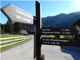 23
23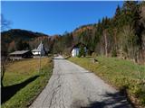 24
24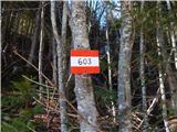 25
25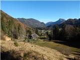 26
26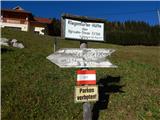 27
27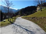 28
28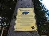 29
29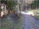 30
30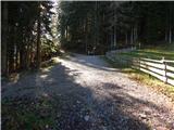 31
31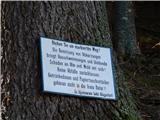 32
32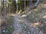 33
33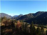 34
34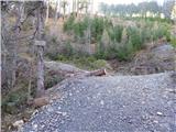 35
35 36
36 37
37 38
38 39
39 40
40 41
41 42
42 43
43 44
44 45
45 46
46 47
47 48
48 49
49 50
50 51
51 52
52 53
53 54
54 55
55 56
56 57
57 58
58 59
59
Discussion about the trip Slovenji Plajberk / Windisch Bleiberg - Kosmatica / Kosmatitza
|
| Janez Seliškar23. 11. 2018 |
Winter is at the door and Kosmatica is an excellent ski touring peak.
|
|
|
To post a comment you must log in:
If you do not yet have a username, you must first
register.