Slovenski planinski muzej - Grančišče (Ferata Mojstrana - Red)
Starting point: Slovenski planinski muzej (658 m)
| Latitude/Longitude: | 46,45810°N 13,93597°E |
| |
Route name: Ferata Mojstrana - Red
Walking time: 1 h
Difficulty: extremely difficult marked way
Via ferrata: C/D
Elevation gain: 186 m
Elevation difference along the route: 186 m
Map:
Recommended equipment (summer): helmet, self belay set
Recommended equipment (winter): helmet, self belay set, ice axe, crampons
Views: 42.640
 | 2 people like this post |
Access to starting point:
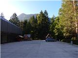
We leave the Gorenjska motorway at the Hrušica exit and follow the road ahead in the direction of Kranjska Gora. Just a little before the village of Dovje, the road to Mojstrana (Vrata, Kot and Krma) branches off to the left from the main road. We follow the road ahead in the direction of Vrata valley, but only to the Slovenian Mountaineering Museum. We park in the parking lot at the museum.
Route description:
From the parking lot at the museum we continue approximately 100 meters along the road towards Vrata, then turn sharply right onto the road (Pod Grančiščem), which leads towards the cliffs of Grančišče. The road leads us past a few houses and then soon on the left side in the forest we notice an information board about secured climbing paths.
We turn left onto the narrow path which leads past the mentioned boards and after a short ascent we come to the first steel cables.
To the right leads a blue somewhat easier path, we continue left on the red harder path. The path already at the beginning almost vertically ascends along the steel cable, which is not entirely taut and therefore pulling on the steel cable is somewhat more difficult. The steepness then slightly eases and brings us below the vertical ladder. Here we also cross the easier blue path. At the junctions where the easier and harder paths cross we follow the red colour on the steel cable. After the ascent over the vertical ladder the path turns right and soon follows a somewhat more demanding crossing where a few pegs assist us. We then continuously ascend an exposed path, which quite well chooses natural passages, here and there also aided by a peg. On the path there is quite a lot of earth and sand so there is also a danger of falling rocks. Higher we cross the easier blue path a few more times, and for a short time the paths unite into one. We continue ascending the exposed path with a nice view of Mojstrana all the way to the end of the secured path where there is also a registration box.
From the registration box only a short ascent follows through sparse forest to a panoramic summit.
For the ascent on the described path use of a via ferrata kit and helmet is mandatory.
We descend on the easy path through the forest, which is marked with a sign „Mojstrana“. The climbing paths are not intended for descent.

Photos:
 1
1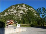 2
2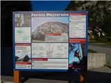 3
3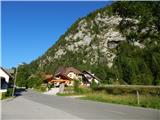 4
4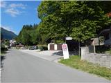 5
5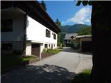 6
6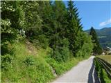 7
7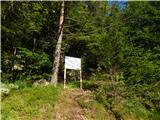 8
8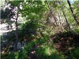 9
9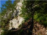 10
10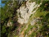 11
11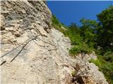 12
12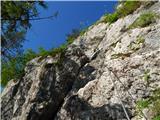 13
13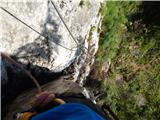 14
14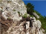 15
15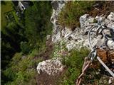 16
16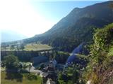 17
17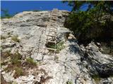 18
18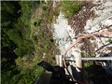 19
19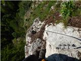 20
20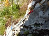 21
21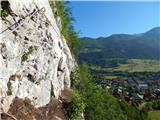 22
22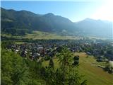 23
23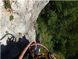 24
24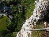 25
25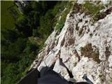 26
26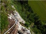 27
27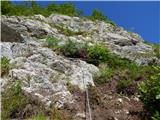 28
28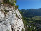 29
29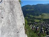 30
30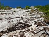 31
31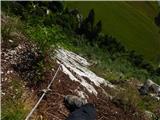 32
32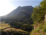 33
33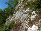 34
34 35
35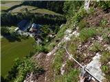 36
36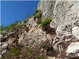 37
37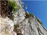 38
38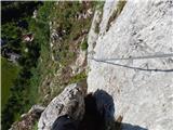 39
39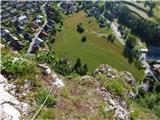 40
40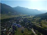 41
41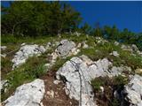 42
42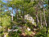 43
43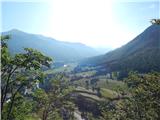 44
44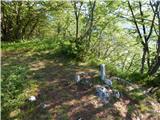 45
45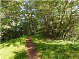 46
46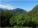 47
47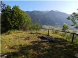 48
48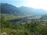 49
49
Discussion about the trip Slovenski planinski muzej - Grančišče (Ferata Mojstrana - Red)
|
| fico11. 07. 2016 |
interesting path, just that one hour is a bit too much for this path. Around 40 minutes there is quite okay, since you don’t need to clip in continuously.
|
|
|
|
| don kihott12. 07. 2016 |
The cable is definitely not there for beauty... On ferratas the cable is for self-belaying... Why is a via ferrata set needed on ferratas then??? Many very experienced ferrate climbers have already flown off due to soloing!!! The ascent and descent time is also objective on ferratas, since you are one of the faster ones and up in 40 minutes, someone else takes 1 hour or an hour and a half for the same path, we don’t all have the same abilities!!!
|
|
|
|
| zico1015. 07. 2016 |
The path is very nicely laid out, on certain sections it gives you a bit of adrenaline, so thumbs up. Nice end to the day after visiting the mountaineering museum 
|
|
|
|
| opavel18. 07. 2016 |
Occasional resident of Mojstrana, I come regularly in summer and winter for at least the last 12 years. These two vias ferratas, in a tourist place and in the valley, 5 minutes from the mountaineering museum, are truly a unique achievement and a positive thing for the area, this is how it should be done, all congratulations.
Personally, I'm not a fan of sporty/difficult vias ferratas, e.g. in the high mountains, because there are other challenges there that one must know how to overcome. But in such a place or in a town with this vertical wall, the matter simply calls for something like this to be done.
I tested the Path of Mojstrana Squirrels yesterday, at my 64 years and 95 kg weight, having already tackled almost all other nearby and distant high-mountain secured paths. I must admit that this harder variant really exhausted me, so after climbing the central part, in the upper part I was already sinfully thinking whether to switch directly to the easier path. I still feel some consequences in my arms today, because without using leg power, especially when clipping the via ferrata set at some difficult spots, it's almost impossible. That declared 1 hour is quite accurate, I took even a bit more, and I'm not a beginner.
So far, my hardest climbed via ferrata was Weg der 26er on Monte Coglians (Hohe Warte) in the Carnic Alps. The Austrians rate it e.g. D+, but it didn't take nearly as much strength from me as the Path of Mojstrana Squirrels (admittedly I was 5 years younger then and it exhausted my wife a lot, so I was glad that this time in Mojstrana she didn't want to go with me on this harder variant of the path). And I agree that a direct comparison with some high-mountain via ferrata, combined with a long approach, cannot be compared to such a short sport climbing path, yet it is sufficiently difficult.
All congratulations for the execution and it's simply genial that there is an easier and harder path, on which e.g. slightly more athletic visitors to the Slovenian Mountaineering Museum can test themselves.
|
|
|
|
| 1mitjas29. 07. 2016 |
We ask all visitors to use the road for access as described here and not to walk through private gardens.
Complaints about this have recently appeared.
|
|
|
|
| GWalker19. 08. 2016 |
Hello!
I'm interested in how this ferrata (red one) compares to Spodnji plot (easier route), or to the ferrata at Češka koča?
Best regards and thanks!
|
|
|
|
| janezs7320. 08. 2016 |
I climbed the Mojstrana via ferrata in May, did the one under Česka Koča once last year in light rain, and I can only compare the lower plot to the right (harder) one; it is substantially easier than Čajnik, somehow comparable or even a shade easier than Bruno Biondi above Glinščica
but all this is more subjective assessment - the Mojstrana via ferrata is thus the easiest for me; the overhanging part has nice holds in the rock, so there are other variants besides pulling on the cable (except the ladder of course).. of course there is always dirt around... it will take some time for the rain to wash away the soil as it should
safe steps to all
and one more thing - don't go into this via ferrata in climbing shoes, because there is too much soil... climbing shoes are only useful in via ferratas like the lower plot (right), where ledges line up one after another
|
|
|
|
| Rok5. 05. 2020 |
It is open. At the starting point there is a notice that wearing full-finger gloves (no fingerless gloves) is mandatory.
|
|
|
|
| Zgembo14. 06. 2020 |
I was yesterday on this via ferrata, it's a bit adrenaline-pumping  conditions super, dry terrain, here's the recording of the whole via ferrata: https://youtu.be/4fSgFYnhisM conditions super, dry terrain, here's the recording of the whole via ferrata: https://youtu.be/4fSgFYnhisM
|
|
|
|
| zvehar13. 06. 2021 13:57:18 |
Was there yesterday, not too demanding, but concentration and thought needed at some points. If you give up midway, there are exits to the blue variant. Also suitable for the start of the season to build some fitness and refresh technique.
Conditions - dry terrain, a bit annoying as gravel and soil still crumble, so caution is not superfluous.
Video from yesterday: https://youtu.be/IamwjT64Rhw
|
|
|
|
| MinasTirith13. 05. 2023 21:34:47 |
Information.
Today 13.5.2023 I wanted to go on the mentioned via ferrata but it is closed due to works/repairs/maintenance…so you won't turn back unnecessarily
|
|
|
|
| balon30. 06. 2023 12:41:32 |
Is the via ferrata open or are maintenance works still ongoing? Has anyone climbed on 13.5.?
|
|
|
|
| balon30. 06. 2023 12:45:24 |
I called SPM and got the answer that the via ferrata is open from today (30.6.2023).
|
|
|
To post a comment you must log in:
If you do not yet have a username, you must first
register.