Šmartno na Pohorju - Ponds Devin in Ošelj
Starting point: Šmartno na Pohorju (780 m)
| Latitude/Longitude: | 46,44504°N 15,54013°E |
| |
Walking time: 35 min
Difficulty: easy marked way
Elevation gain: 32 m
Elevation difference along the route: 85 m
Map: Pohorje 1:50.000
Recommended equipment (summer):
Recommended equipment (winter): ice axe, crampons
Views: 278
 | 1 person like this post |
Access to starting point:
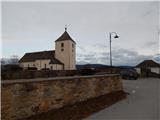
We leave the Styrian motorway at the Slovenska Bistrica south or north exit (depending on which direction we come from), then we drive into the centre of Slovenska Bistrica, from where we head on the road in the direction of the settlement Šmartno na Pohorju. A few kilometres of ascent follow, and we follow the road in the direction of the mentioned settlement. When we arrive at Šmartno na Pohorju, we park on a smaller arranged parking lot by the cemetery and church of St. Martin.
Route description:
From the parking lot in a few steps we walk to the main road which leads through the settlement, and we follow it to the right, where the blazes also point us. For a short time, we walk through the center of the settlement, then with nice views we walk to a smaller crossroad by a somewhat larger chapel.
Here we continue straight (right Ruška koča na Arehu - path over Frajhajm) and a few minutes further we arrive at the next marked crossroad, from which we continue left towards the Three Kings (straight Ruška koča na Arehu). We bypass the nearby houses on the left side, then we continue by the pasture. Further, we lightly descend on a poorer road; when the road turns sharply left, we continue straight on the path that goes into the forest. The path ahead leads us past a trough with water, then Knafelc blazes direct us to the left (straight guesthouse Dovnik). A little further, over a small bridge, we cross the Devina stream, and we follow the blazes. A short steep ascent follows, then the path flattens somewhat and leads us out of the forest, where we cross a meadow diagonally to the right. Higher up at the edge of the forest we reach a cart track which brings us to the lower pond in Ošelju.
We bypass the mentioned pond on the right side, and on a poorer road in two minutes we reach the upper pond in Ošelju as well.
Description and pictures refer to the condition in January 2022 and May 2023.

Photos:
 1
1 2
2 3
3 4
4 5
5 6
6 7
7 8
8 9
9 10
10 11
11 12
12 13
13 14
14 15
15 16
16 17
17 18
18 19
19 20
20 21
21 22
22 23
23 24
24 25
25 26
26 27
27
Discussion about the trip Šmartno na Pohorju - Ponds Devin in Ošelj
To post a comment you must log in:
If you do not yet have a username, you must first
register.