Šmartno na Pohorju - Šetorov mlin
Starting point: Šmartno na Pohorju (780 m)
| Latitude/Longitude: | 46,44504°N 15,54013°E |
| |
Walking time: 45 min
Difficulty: easy marked way
Elevation gain: -35 m
Elevation difference along the route: 30 m
Map: Pohorje 1:50.000
Recommended equipment (summer):
Recommended equipment (winter):
Views: 703
 | 1 person like this post |
Access to starting point:
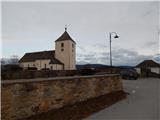
We leave the Štajerska highway at the exit Slovenska Bistrica south or north (depending on which direction we come from), and then we drive into the center of Slovenska Bistrica, from where we go on the road in the direction of the settlement Šmartno na Pohorju. There follow a few kilometers of ascent, and we follow the road in the direction of the mentioned settlement. When we get to Šmartno na Pohorju, we park on a smaller arranged parking lot at the cemetery and church of St. Martin.
Route description:
From the parking lot in a few steps we walk to the main road which leads through the settlement, and we follow it to the right, where the blazes also direct us. For a short time, we walk through the center of the settlement, and then with nice views we walk to a smaller crossroad by a somewhat larger chapel.
Here we continue straight (right Ruška koča na Arehu - path via Frajhajm) and a few minutes further we get to the next marked crossroad, from which we also continue straight (left Sv. Trije kralji) and we moderately ascend past individual houses and inn Dovnik. Next follows crossing a strip of forest, and then we descend a little to a crossroad, where we continue right towards Areh and Bojtina.
After the crossroad, the road descends even a little more, and we go from the road slightly right onto a parallel mountain path, which continues descending. Lower, the path flattens and past a newer and older building brings us back to the road, which we follow to the right. On the road over the bridge we cross the stream and we go past a cross, after the cross we go from the road slightly right onto a worse road or cart track in the direction of Šetorov mlin. There follow a few minutes of easy walking, and after the wooden cottage we soon go right downwards and descend to Šetorov mlin.
Description and pictures refer to the condition in January 2022.

Photos:
 1
1 2
2 3
3 4
4 5
5 6
6 7
7 8
8 9
9 10
10 11
11 12
12 13
13 14
14 15
15 16
16 17
17 18
18 19
19 20
20 21
21 22
22 23
23 24
24 25
25 26
26 27
27
Discussion about the trip Šmartno na Pohorju - Šetorov mlin
To post a comment you must log in:
If you do not yet have a username, you must first
register.