Starting point: Sora (360 m)
| Latitude/Longitude: | 46,14140°N 14,37030°E |
| |
Route name: footpath
Walking time: 50 min
Difficulty: easy marked way
Elevation gain: 355 m
Elevation difference along the route: 355 m
Map: Ljubljana - okolica 1:50.000
Recommended equipment (summer):
Recommended equipment (winter):
Views: 21.675
 | 4 people like this post |
Access to starting point:
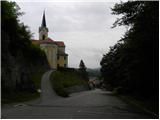
A) First, we drive to Medvode, then at the Spar store we leave the main road and continue towards the railway station and settlement Sora. In Sora, first the road towards Katarina branches off to the left, and a little ahead also towards Osolnik. We drive on the road towards Osolnik and then after a shorter ascent we park on the parking lot below the church of St. Štefan. We can also park a little lower on the parking lot by the presbytery.
B) From Kranj we drive towards Škofja Loka, from the periphery of Škofja Loka then we follow the signs for Gorenja vas. Before the Sten tunnel from the roundabout we take the exit in the direction of the settlement Sora. Further, we drive through the settlements Hosta, Pungert, Gosteče and Draga, to the settlement Sora, where we turn right towards Osolnik and then after a shorter ascent we park on the parking lot below the church of St. Štefan. We can also park a little lower on the parking lot by the presbytery.
C) From Poljanska valley we drive towards Škofja Loka and then on the bypass and through the Sten tunnel. After the tunnel we turn right and follow the signs for the settlement Sora. Further, we drive through the settlements Hosta, Pungert, Gosteče and Draga, to the settlement Sora, where we turn right towards Osolnik and then after a shorter ascent we park on the parking lot below the church of St. Štefan. We can also park a little lower on the parking lot by the presbytery.
Route description:
From the parking lot at the church of St. Štefan we continue on the asphalt road, which moderately ascends and after a short ascent brings us to a sharp left turn. Only a little above the mentioned turn, from the road a marked footpath branches off sharply to the right, which leads to Hom and Osolnik. We head onto the mentioned path, which goes into a dense forest and starts to ascend more steeply. Higher, the path flattens for a short time and gets very close to the road to Osolnik.
We continue slightly right on the marked mountain path, which a little higher splits into two parts. We again continue right in the direction of Hom (slightly left Osolnik - path which bypasses the peak of Hom on the left side) on an increasingly steep path. The path higher flattens, then in a few minutes of further walking brings us to the summit of Hom, from which a nice view opens up towards Gorenjska.
The trip can be extended to the following destinations: Osolnik (1 h)
Photos:
 1
1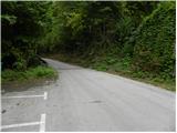 2
2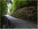 3
3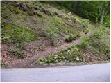 4
4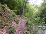 5
5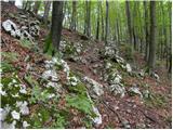 6
6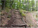 7
7 8
8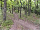 9
9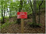 10
10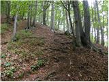 11
11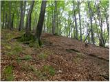 12
12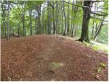 13
13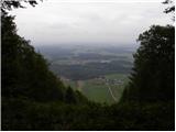 14
14
Discussion about the trip Sora - Hom (footpath)
|
| Gost27. 11. 2007 |
From Hom continue the path to scenic Osolnik (45 min.), from there via Gontarska planina to Tošč and Grmada. Diligent walkers can continue to Katarina, Sv. Jakob and then along the edge back to Sora. Such a path takes about 7 hours, is very beautiful, with views to Gorenjska with Grintovci, to Škofja Loka, towards Ljubljana. The path can be ended earlier, as marked paths already lead to the Ločnica valley and starting point. Very nice paths also for the winter season coming.
|
|
|
|
| mcatar14. 11. 2010 |
With a colleague and children we had a really nice trip. The path is quite steep in places, the upper part below the summit is a bit too steep for our six-year-olds, not very used to hills. We descended to the valley on the other side of the hill (we followed the left marked path and not the right one towards Osolnik). After a few dozen meters of descent, we turned back towards Sora at the junction.
The descent on the western side of Hom is much gentler and can also be used for ascent.
You can get the GPS track of the trip at: http://www.everytrail.com/view_trip.php?trip_id=884004
|
|
|
|
| KristinaG14. 11. 2010 |
I can't see the GPS track because it's "private", but from the description it's hard to imagine where you went. I assume you went up the shorter path (sign Hom 15 minutes). For children it's nicer if you don't turn right here, but keep left. And then higher up, at the sign turn right. But even here the path might be a bit steep in one section (for children).
|
|
|
|
| Alias989814. 07. 2017 |
Nice hill and nice trail. But the last meters are really noticeably steeper and almost a bit surprising. If children are used to it no problem, if not be a little careful so they don't end up on their knees and it's all fine. The view is wonderful, worth it at least for that 
|
|
|
|
| di9. 04. 2025 17:55:57 |
Hills conquered:
Brezje, Hom, Žebnik
|
|
|
To post a comment you must log in:
If you do not yet have a username, you must first
register.