Sovodenj - Bevkov vrh (gentle path)
Starting point: Sovodenj (592 m)
| Latitude/Longitude: | 46,08500°N 14,03860°E |
| |
Route name: gentle path
Walking time: 1 h 30 min
Difficulty: easy marked way
Elevation gain: 459 m
Elevation difference along the route: 459 m
Map: Škofjeloško in Cerkljansko hribovje 1:50.000
Recommended equipment (summer):
Recommended equipment (winter):
Views: 36.483
 | 3 people like this post |
Access to starting point:
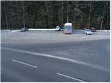
A) From Ljubljana or Kranj, we drive to Škofja Loka, from where we continue towards Gorenja vas. In Gorenja vas, we continue right in the direction of Cerkno and Žiri. The road then takes us past the village of Trebija, after which we turn right in the direction of Cerkno (left Žiri). We follow this road to the village of Sovodenj, where we park on the parking lot between the store and the fire station.
B) From Tolmin, we drive to Cerkno and follow the road ahead towards Škofja Loka. When we come to the village of Sovodenj, we park on the parking lot between the store and the fire station.
Route description:
From the parking lot, we continue on the left road, which leads us past the fire station. After a few steps of walking, at the refreshment place a marked road branches off to the right upwards in the direction of Bevkov vrh. The road first steeply ascends and after the first sharp left turn loses the asphalt surface. The steepness of the road then eases and a little further brings us to the place where a marked cart track branches off to the right upwards. The branch-off is poorly marked!
The cart track first ascends through the forest and then across grassy slopes brings us to the village, where we reach the road. We continue right and the path soon brings us to a path junction, where we continue left along the road in the direction of Bevkov vrh on the SPP. The road after a few minutes brings us to the other part of the village, where a marked cart track branches off to the left onto grassy slopes. The cart track gently ascends across grassy slopes and higher brings us to the next hamlet. A short descent on the road follows and the path brings us to a junction, where we continue right upwards. We follow the road to the next houses, where the path from Sivka joins from the left.
Here we continue right upwards past the houses onto grassy slopes across which we ascend at a moderate incline. In the upper part of the meadow the path turns left into the forest, where without major ascents and descents it crosses the slopes of Bevkov vrh. Further we follow the path, which brings us to ruined houses, where we notice the signs "žig pri kapelici". Further we ascend past the houses to the chapel, where the stamp is.
From the chapel we can also ascend to the forest-covered Bevkov vrh, which is a five-minute walk from here in the direction of Sovodenj.

Photos:
 1
1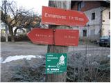 2
2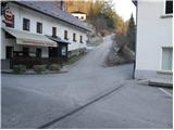 3
3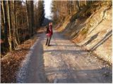 4
4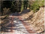 5
5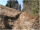 6
6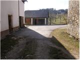 7
7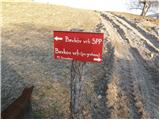 8
8 9
9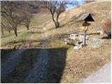 10
10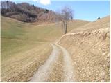 11
11 12
12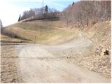 13
13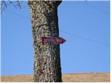 14
14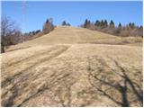 15
15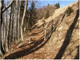 16
16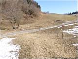 17
17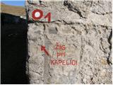 18
18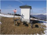 19
19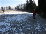 20
20 21
21
Discussion about the trip Sovodenj - Bevkov vrh (gentle path)
|
| žerjavček1. 04. 2012 |
Just a short note: (In the upper part of the meadow the trail turns left into the forest, where without major ascents and descents it crosses the slopes of Bevkov vrh.).
We descended via this trail. Currently the trail is on a short section "clogged" with felled trunks, branches. Bypass is along the left slope.
|
|
|
|
| frenk4512. 08. 2012 |
I didn't find the chapel today, did they demolish it or something
|
|
|
|
| balon22. 06. 2014 |
Is the path passable today?
Balončki
|
|
|
|
| balon20. 07. 2014 |
Yesterday we were at the top, nice path, not demanding at all, suitable for children of all ages. I would just point out the fact that there could be some more markings or signs.
Balončki
|
|
|
|
| KARAMELICA30. 12. 2014 |
We went to Bevkov vrh last Sunday and couldn't believe that just above Sovodenj there is such a wonderful view of the surrounding hills. Great hike  . I agree with balon that there should be more markings or signs. We had quite a bit of trouble finding the right path to the top. . I agree with balon that there should be more markings or signs. We had quite a bit of trouble finding the right path to the top.
|
|
|
|
| claire20. 06. 2015 |
Today we set out with my colleagues for Bevkov vrh, but unfortunately we didn't conquer it. We circled around the "summit" like satellites. The trail is very poorly marked... The grass isn't mowed, dogs are off-leash, locals are almost nowhere to be found. I hope the markings will be installed soon and that we'll find the summit next time.
|
|
|
|
| navdušena31. 12. 2015 |
I haven't been to Bevkov vrh for a while, but I'm going hiking on 2.1. In excuse for the poor markings, there was probably an ice storm raging in those areas and many trees are felled, likely some with markings too. The summit is in the forest, the stamp is at the chapel a bit below the summit - at least that's how it used to be...
|
|
|
|
| slavkoo3. 07. 2018 |
Has anyone been to Bevkov vrh from Sovodenj recently? Is the path well marked? Stamp?
|
|
|
|
| Lisica3. 07. 2018 |
I went up there a few years ago several times and took this path description with me, and it went without problems. The bigger problem was when I continued from Bevkov towards Sivka.
|
|
|
|
| slavkoo4. 07. 2018 |
Today I set off from Sovodenj to Bevkov vrh. The path is interesting, varied, unfortunately as many have said, poorly marked in the upper part. Praise to PD Sovodenj for the small wooden "chapel with bar and schnapps", but they could also put up a signpost for the real Bevkov vrh. I didn't find it.
|
|
|
|
| martin97023. 10. 2023 10:04:11 |
The chapel and stamp are located another 10 minutes walk ahead
from the summit of Bevkov vrh (1051m) from the forest onto the meadow. Keep the same direction for another 10 minutes straight across the meadow to the small woods (fence). When you reach the small woods, cross it (a few steps). A view opens to a large meadow, continue in the same direction, in the middle of which you notice the chapel. The stamp is at the chapel. You can also help yourself by typing the location into Google Maps: 32Q2+W3R Cerkno.
Confusion arises because the SPP path does not go over the "summit" of Bevkov vrh, but past the chapel.
|
|
|
|
| Fulcrum23. 12. 2023 17:57:35 |
Today I decided to visit Bevkov vrh via the gentle path. The path is poorly marked, so I reached the top partly by the described path, partly my own way. From the junction (picture 8) onwards I saw no more markers, only here and there an old signpost, half of which lie broken by the path. 
From the top, the chapel with the stamp cannot be seen due to the forest and uneven terrain. Best to follow the power line, as the said chapel is located along its route, towards NW.
I returned via the steep path, which is excellently marked.
|
|
|
To post a comment you must log in:
If you do not yet have a username, you must first
register.