Sovodenj - Bevkov vrh (steep way)
Starting point: Sovodenj (592 m)
| Latitude/Longitude: | 46,08500°N 14,03860°E |
| |
Route name: steep way
Walking time: 1 h 15 min
Difficulty: easy marked way
Elevation gain: 459 m
Elevation difference along the route: 459 m
Map: Škofjeloško in Cerkljansko hribovje 1:50.000
Recommended equipment (summer):
Recommended equipment (winter):
Views: 30.963
 | 5 people like this post |
Access to starting point:
A) From Ljubljana or Kranj we drive to Škofja Loka, from where we continue towards Gorenja vas. In Gorenja vas we continue right in the direction of Cerkno and Žiri. The road then runs past the village of Trebija, after which we turn right in the direction of Cerkno (left Žiri). We follow this road to the village of Sovodenj, where we park on the parking lot between the store and the fire station.
B) From Tolmin we drive to Cerkno and follow the road ahead towards Škofja Loka. When we come to the village of Sovodenj we park on the parking lot between the store and the fire station.
Route description:
From the parking lot, we continue on the left road, which leads us past the fire station. After a few steps of walking, at the snack bar a marked road branches off right upwards in the direction of Bevkov vrh. The road first steeply ascends and after the first sharp left turn loses its asphalt surface. The steepness of the road then decreases and a little further brings us to the spot where a marked cart track branches off right upwards. The turn-off is poorly marked!
The cart track first ascends through the forest and then across grassy slopes brings us to the village, where we come onto the road. We continue right and the path soon brings us to the junction of paths, where we continue right in the direction of Bevkov vrh along the ridge (steep path). We continue on the cart track, which has quite a few junctions, but they are well marked. The cart track then brings us into the forest, where it turns into a footpath. The path, which occasionally steeply ascends, soon brings us to the forested Bevkov vrh.
If we want to get to the stamp, we must descend across grassy slopes in the direction of Ermanovec (5 min). The stamp is located on a panoramic ridge near the chapel.

Photos:
 1
1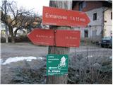 2
2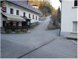 3
3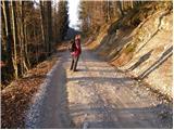 4
4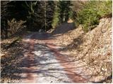 5
5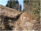 6
6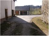 7
7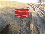 8
8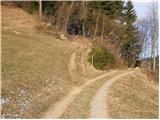 9
9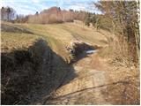 10
10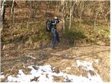 11
11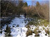 12
12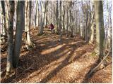 13
13 14
14
Discussion about the trip Sovodenj - Bevkov vrh (steep way)
|
| jozo14. 01. 2010 |
Was on Bevkov vrh today, from Sovodenj. Quite a lot of snow on the path, nature beautiful at this time of year. On the summit box with logbook and stamp, no need to go to chapel for it.
|
|
|
|
| m15. 01. 2010 |
Hello!
Finally, common sense prevailed.
Really nice that they finally remembered and the box with logbook and stamp is at the summit itself, not that you had to go down across a really big meadow where you didn't know where to go, and then along the little forest to the other side, to the chapel.
It wouldn't be bad if the path to the chapel was better marked, but who would think the stamp isn't at the top. And this is a summit on the transverse! Locals said many got confused and went only to the stone (at the very summit). I called their PD (admit; it was holiday time) and they couldn't tell me exactly where the stamp on Bevkov vrh is. Luckily a guy with tractor for bales came and showed me the way.
Great that it's fixed. Commendable.
|
|
|
|
| niki15. 01. 2010 |
Hello!
I agree the stamp is at the top. Pity not to go to the chapel, view really beautiful, only markings should be better, as at end of forest you can really get lost.
|
|
|
|
| joža x15. 01. 2010 |
Can I count on a track Sunday on route Pl.dom Ermanovec-Bevkov vrh-Sovodenj-Pl.dom Ermanovec and how much snow?
|
|
|
|
| jozo15. 01. 2010 |
Given that the hut at Ermanovec is open on weekends, I think the number of visitors on the path will be higher, and the path will be accordingly. There is about 30 to 40 cm of snow at the top.
|
|
|
|
| Ajda_Zitnik11. 09. 2011 |
Today we went with the kids on this path. The path is exemplary maintained, it might be good to draw some additional markings, especially at junctions (although with a bit of good reasoning and good eyes you can find the path here too).
The stamp and logbook are still at the top, but I advise taking a stamp pad with you.
Also, the last part of the path is really steep and caution is not superfluous (especially when crossing the meadow, where it was slippery in the morning despite the warm morning due to dew).
Addition to the description:
The junction which is said to be poorly marked (visible in picture 5.) is now equipped with a direction sign saying Bevkov vrh.
|
|
|
|
| Kokta13. 12. 2011 |
In short...one of the worse marked paths on SPP. At least at three places it would be necessary to mark the path, because you blindly decide where to go. Stamp and book are at the top. As for the path to the chapel....the problem arises when you reach the clearing, just as m.... mentions no signs at all. Also problem at picture 10 a bit higher.
Otherwise the path is easy and suitable for families.lp
|
|
|
|
| bo_zl15. 12. 2011 |
also my comment on the markings or signs. at the beginning of November I did the circular path Sovodenj-Bevkov vrh-Ermanovec-Sovodenj. On the descent from the chapel at Bevkov vrh to the lower farm there is no problem. Then the sign for Ermanovec is indeed at the junction, but it kind of leads the hiker on the footpath across the meadow.... but the real path is on the asphalt.... here some additional sign or sufficiently visible markings wouldn't hurt...
|
|
|
|
| katty15. 12. 2011 |
Can you make a circular path Sovodenj-Slajka-Sivka-Ermanovec-Bevkov vrh-Sovodenj? Yeah, that's the circular path I would do to cover all these peaks. Somehow I'm drawn to these parts.
|
|
|
|
| užitkar16. 12. 2011 |
It's possible to do the path Sovodenj-Sivka-Bevkov vrh-Ermanovec-Slajka, the return path to Sovodenj would be more along the road, because even the above described one would have to go more along local paths and is not fully marked, map and fitness mandatory, quite a few kilometers...
LP
|
|
|
|
| jure197716. 12. 2011 |
Last year I alone hiked the path Sovodenj-Ermanovec-Bevkov vrh-Sivka-Sovodenj. The path was well marked, only a little below the top of Sivka I didn't exactly know where the top was... From Sivka back to Sovodenj you need to go along the asphalt road, a bit through the forest, the path is not marked, but if you have a map with you, there's practically only one road, so there shouldn't be problems.
|
|
|
|
| Janiel744. 05. 2012 |
The path is well marked and you can't get lost. But I don't know where you were looking when saying there's no view from the top??? Of course there is From the top of that mighty mountain exactly 2463 trees are visible))
|
|
|
|
| ce_belica23. 07. 2013 |
My friend and I were on Bevkov vrh today. We had a great day, but we'd like to warn that from Sovodenj on some sections the path is very poorly marked and we had trouble finding the right path. At some junctions there are no markers, the hiking path is poorly visible. Some markers are on stones covered by grass. Some signposts are so low (with a low "pole") that you don't notice them right away or they are covered (with grass, towards the top there was a lot of hay in front of the signpost and it wasn't visible at all.
|
|
|
|
| B.Smart4. 12. 2013 |
Yesterday I walked the mentioned path. I also had initial orientation issues, as new asphalt has been laid, with a few hundred meters of gravel in between. Right at the beginning of the new asphalt, there's a tree with a mark on the left by the path, while a cart track branches off to the right. I assumed it was the right turn, but after a few hundred meters I reached a house from which I didn't know how to proceed. So I returned and continued on the asphalt, with no marks. When I got 200 m further to the next house, I finally noticed the mark and then the correct turn ahead, which is obviously newly signposted with a large sign for Bevkov vrh. From there on, I had no problems. It seems they must have freshly marked the path recently, as there were plenty of marks from the sign onwards.
A completely different story is the return via the flat scenic path, which is supposed to be transversal. There I walked more or less by guesswork and occasionally found a mark that only indicates the direction to Sivko.
It was a beautiful, though windy and cold winter day, perfect for dispelling fatigue after a strenuous duty shift
|
|
|
|
| Čeladarka5. 10. 2015 |
Today I was at Bevkov vrh. The path seems to me adequately marked, but at times not very pleasant due to fallen trees and branches.
At that green stone on the summit, there is a sign pointing towards the chapel. On the way there, you need to cross a pasture and step over two electric shepherds. The chapel is, in my opinion, impossible to miss, as it can be seen from afar through the green trees. There is also a box with a logbook and a newer stamp (1051 m!).
In clear weather, the view of Cerkljansko hribovje is wonderful. Porezen and part of Kamniško Savinjske Alpe are clearly visible.
|
|
|
|
| tavzentroza21. 10. 2015 |
Today visited Bevkov vrh, this stamp was still missing from this part of SPP. The path from Sovodenj is properly marked, perhaps a mark is missing under the summit, but there are still broken trees. With aggressive intervention in the environment with a forest path, probably some mark was destroyed and no one replaced it with a new one.
It was somewhat more difficult to find the chapel where the stamp is, otherwise I don't know why it's not at the top.
Otherwise nice views, with Triglav in the background and the entire chain of lower Bohinj mountains. Back the same way, although the sign at the farm below indicates two paths, steep and gentler, scenic. However, from the chapel back to Sovodenj there were no signs directing to the other path.
|
|
|
|
| ucakakla15. 01. 2016 |
Hello,
Can you tell us if the path from Bevkov vrh to Koča na Ermanovcu is clearly marked? Would it be better to do the reverse path?
Thank you and best regards
|
|
|
|
| marinka6722. 07. 2016 |
well, we walked like crazy across that meadow looking for the chapel, each at their end of the ridge, as the markers are overgrown in the grass and hidden behind bales. For help: when you reach the meadow from the top, keep to the right, along the track towards the power lines, bypass the little forest on the right side and in the middle of the meadow you spot the chapel. 5 min before our arrival, a man with a tractor sprayed the meadow with manure.  . What can you do, that also belongs to nature and mountains. . What can you do, that also belongs to nature and mountains.  We quickly stamped and fled back to the forest. We quickly stamped and fled back to the forest.
|
|
|
|
| tenorist10. 11. 2019 |
Hello. Today I visited Bevkov vrh. The path is pleasant and quite well marked to the summit. From the summit to the chapel, however, there is only one mark. It says STAMP and an arrow pointing to the chapel where the stamp is. I have to say, though, I was disappointed with the stamp. There are two, but in very poor condition. The first is on an iron rod and the imprint is very very poor. The second, in the box, is also in poor condition. It looks like it's melted. Probably due to the summer heat. I suggest putting the iron stamp in the box so that weather doesn't destroy it. Of course, attached with a chain so it doesn't grow legs
|
|
|
|
| Pale27. 02. 2022 16:56:15 |
The path is well marked, many markers look new (fresh). Despite the drifted snow, there were no orientation problems. Up the ridge path, down the gentle path. The stamp in the box at the chapel is also completely new. Marinka's upper description of how from the summit to the chapel was helpful.
|
|
|
|
| drevo6. 08. 2022 19:22:20 |
Nice path. At the top of Bevkov vrh, getting to the logbook on the other side of the large meadow by the chapel is a bit tricky to find. It would be good to add a photo here or mark it on the ground.
|
|
|
|
| martin97024. 10. 2023 08:11:11 |
The chapel and stamp are located another 10 minutes walk ahead
from the summit of Bevkov vrh (1051m) from the forest onto the meadow. Keep the same direction for another 10 minutes straight across the meadow to the small woods (fence). When you reach the small woods, cross it (a few steps). A view opens to a large meadow, continue in the same direction, in the middle of which you notice the chapel. The stamp is at the chapel. You can also help yourself by typing the location into Google Maps: 32Q2+W3R Cerkno.
Confusion arises because the SPP path does not go over the "summit" of Bevkov vrh, but past the chapel.
|
|
|
|
| Tbs4. 05. 2024 11:44:41 |
Hi Has anyone been to Bevkov vrh recently and can tell me, please, where the stamp is?
Thanks
|
|
|
|
| valerija1124. 05. 2024 21:06:25 |
The stamp is located at the chapel.
Nice evening
|
|
|
|
| Tbs4. 05. 2024 22:16:32 |
Thanks Yes, I went today, excellently marked, it was almost harder to find the actual summit than the stamp
|
|
|
To post a comment you must log in:
If you do not yet have a username, you must first
register.