Sportgastein - Hinterer Geißlkopf (via Hagener Hütte)
Starting point: Sportgastein (1570 m)
| Latitude/Longitude: | 47,06152°N 13,05771°E |
| |
Route name: via Hagener Hütte
Walking time: 5 h 15 min
Difficulty: partly demanding marked way
Elevation gain: 1318 m
Elevation difference along the route: 1355 m
Map:
Recommended equipment (summer):
Recommended equipment (winter):
Views: 328
 | 1 person like this post |
Access to starting point:
On the Tauern motorway in Austria take the exit for Bischofshofen and follow the road in the direction to Zell am See. After a little more than 20 km from Bischofshofen, take a left turn for Bad Hofgastein and Bad Gastein. Continue to Sportgastein and park at one of the big parking places (ski resort area). An alternative option is a motorail connection between Mallnitz and Bad Gastein. You will save 150 km one way with this option (along with tunnel tolls at Tauern motorway). Public transport is also an option (a combination of a train and a bus).
Route description:
The trail from Sportgastein first crosses the vast Gasteiner-Tal a.k.a. Nassfeld valley (Nassfeldalm). There are a lot of markings in the valley, since there are also many visitors (most of these are leisure walkers, who turn back at the end of the valley).
At the beginning of the trail on the right side stands the hut Valeriehaus. Just after a couple of minutes of walking there is the Schareck mountain pasture (Schareckalm) on the right side of the trail. Numerous mountain pastures follow to the end of the valley. Soon on the right are Moisesalm and Pottingeralm. Here the trail to Schareck branches off. Then on the left Nassfeldalm. At the end of the valley, where the trail starts to ascend, stands Veitbaueralm. The trail is flat for about half an hour to here, then it steeply ascends along the glacial moraines. The hiker gains more than 800 meters of altitude in the next two and a half hours and arrives at the Hagener Hütte (2446 m).
From the hut descend to the signs by the bell and continue westwards. The trail gently leads to a ground spring and then starts ascending. About 150 height meters later it reaches the saddle, from which the 2727 m high Westerfrölkekogel rises to the north. The trail is a bit gravelly just below the saddle and requires careful steps.
Since the ridge left of the saddle rises very steeply and impassably, the trail crosses it in the lower right part: first descend into a small basin, cross some rock slabs and then ascend towards the ridge. The ridge is then a nice flat plateau world, which first ascends gently, then becomes steeper again. The trail leads over some pre-summit, from where a nice view opens to the summit of Vorderer Geißlkopf. In early summer - possibly until the beginning of August and in early autumn (e.g. first snow) – snow persists stubbornly on the northern slopes.
The trail runs along the northern slope below Vorderer Geißlkopf to the ridge between Vorderer and Hinterer Geißlkopf. From here just follow the ridge west to the summit, from where there is a nice view of the neighbouring summit Vorderer Geißlkopf and the lake and Feldseekopf on the south side. In the distance to the west the Großglockner is also visible. Northwards about 1500 meters lower lies the valley leading to Sportgastein.
Sportgastein - Hagener Hütte (3 h 15 min); Hagener Hütte – Hinterer Geißlkopf (2 h).

Along the route: Valeriehaus (1580m), Schareckalm (1620m), Pottingeralm (1605m), Moisesalm (1620m), Nassfeldalm (1605m), Veitbauernalm (1645m), Hagener Hütte (2446m)
Photos:
 1
1 2
2 3
3 4
4 5
5 6
6 7
7 8
8 9
9 10
10 11
11 12
12 13
13 14
14 15
15 16
16 17
17 18
18 19
19 20
20 21
21 22
22 23
23 24
24 25
25 26
26 27
27 28
28 29
29 30
30 31
31 32
32 33
33 34
34 35
35 36
36 37
37 38
38 39
39 40
40 41
41 42
42 43
43 44
44 45
45 46
46 47
47 48
48 49
49 50
50 51
51 52
52 53
53 54
54 55
55 56
56 57
57 58
58 59
59 60
60 61
61 62
62 63
63 64
64 65
65 66
66 67
67 68
68 69
69 70
70 71
71 72
72 73
73 74
74 75
75 76
76 77
77 78
78 79
79 80
80 81
81 82
82 83
83 84
84 85
85 86
86 87
87 88
88 89
89 90
90 91
91 92
92 93
93 94
94 95
95 96
96 97
97 98
98 99
99 100
100 101
101 102
102 103
103 104
104 105
105 106
106 107
107 108
108 109
109 110
110 111
111 112
112 113
113 114
114 115
115 116
116 117
117 118
118 119
119 120
120 121
121 122
122 123
123 124
124 125
125 126
126 127
127 128
128 129
129 130
130 131
131 132
132 133
133 134
134 135
135 136
136 137
137 138
138 139
139 140
140 141
141 142
142 143
143 144
144 145
145 146
146 147
147 148
148 149
149 150
150 151
151 152
152 153
153 154
154 155
155 156
156 157
157 158
158 159
159 160
160 161
161 162
162 163
163 164
164 165
165 166
166 167
167 168
168 169
169 170
170 171
171 172
172 173
173 174
174 175
175 176
176 177
177 178
178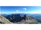 179
179
Discussion about the trip Sportgastein - Hinterer Geißlkopf (via Hagener Hütte)
To post a comment you must log in:
If you do not yet have a username, you must first
register.