Starting point: Srednji vrh (1000 m)
| Latitude/Longitude: | 46,48940°N 13,83710°E |
| |
Walking time: 2 h
Difficulty: easy unmarked way
Elevation gain: 737 m
Elevation difference along the route: 737 m
Map: Kranjska Gora 1:30.000
Recommended equipment (summer):
Recommended equipment (winter): ice axe, crampons
Views: 55.127
 | 4 people like this post |
Access to starting point:
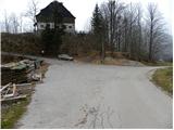
From the highway Ljubljana - Jesenice, take the exit Jesenice - west (Hrušica) and continue driving towards Kranjska Gora. When we arrive in Gozd-Martuljek, we turn right towards Srednji vrh and drive up a narrow and steep road to the mentioned place. When the road flattens a little, we will come to an intersection of several roads and a turning area. Here we park in a suitable spot at the intersection.
Route description:
From the crossroad, we continue on the left ascending road by which we notice signs "Trupijevo poldne". This road, which leads us past the dairy Pr' Hlebanju and the turn-off to the path to Trupejevo poldne, we then follow to the end of the road at the farm Jurež (Ecological farm pri Merklnu). We continue past the farm building, and then just before the residential house we continue sharply right on a cart track which ascends between the two buildings. We continue on the cart track, which ascends over a panoramic hayfield, then turns left and gradually enters the forest through which we ascend for quite some time. The path soon crosses a small spring and then quickly brings us to a fork of two cart tracks. We continue on the right (the left ends at the ruined bridge), which a little further brings us out of the forest onto grassy slopes. Here the trail becomes somewhat indistinct, but during the entire ascent we keep to the right edge of the grassy slope there. Higher we step onto the road which leads from Korensko sedlo towards Železnica, which we merely cross, and continue the ascent on a less trodden and initially harder-to-follow trail, which ascends over a somewhat steeper grassy slope. The poorer trail continues along an indistinct little valley and higher enters the forest, where it becomes easier to follow and turns left. There follow a few minutes of ascent through the forest, then we arrive at the summit grassy slope of Vošca. There follows a moderate ascent somewhat to the left, towards the ruins which we see on the summit of Vošca, and we reach there without major difficulties in a few minutes of further walking, amid ever finer views of the surrounding mountains.

Photos:
 1
1 2
2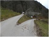 3
3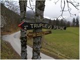 4
4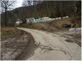 5
5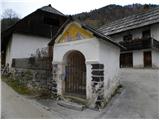 6
6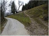 7
7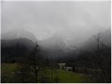 8
8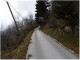 9
9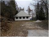 10
10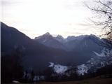 11
11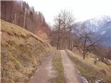 12
12 13
13 14
14 15
15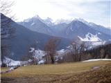 16
16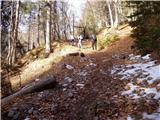 17
17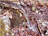 18
18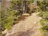 19
19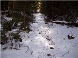 20
20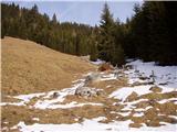 21
21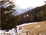 22
22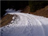 23
23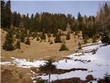 24
24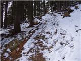 25
25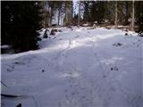 26
26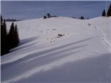 27
27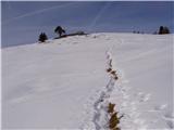 28
28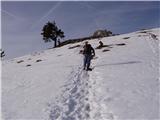 29
29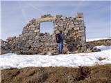 30
30 31
31
Discussion about the trip Srednji vrh - Vošca
|
| matej2. 06. 2007 |
Very nice excursion. The description is very well given, so no orientation problems on the path. I recommend to everyone who likes peace and beautiful views. Matej
|
|
|
|
| Parkeljc6. 12. 2010 |
This morning we tackled it with snowshoes towards Vošca. Initially the snow was dry and not too heavy for walking. To the top we needed just over two hours. Occasionally the sun wanted to peek out from behind the clouds - in vain, clouds covered it again and again, the wind was blowing stronger and stronger. On the way back, in the upper part there was no track left at all, wind-blown snow had completely covered it, then it started snowing, a bit lower the snow was getting heavier and heavier, because lower down it was lightly drizzling all the way. When we reached the first hayloft or something similar above Jurež it was so heavy that it was really hard to pull out the snowshoes. Back in 40 min. Just behind the former guard post there were some small avalanches triggered, soon after Jurež too. Despite windy and bad weather a pleasant trip.
|
|
|
|
| melitad26. 01. 2012 |
The descriptions of the two parking spots are not very precise if you start the ascent in Srednji vrh. We two got quite lost today in the forest on the steep slope, where we had no view at all of where we were. We had to give up before reaching the forest road. On the descent we came across the correct path to Jureževa farm.
First parking description: 'When the road levels out a bit, we will come to a junction of larger roads and a turning area.' I suggest: PARKING BELOW/BEFORE THE VILLAGE SREDNJI VRH
Second description: 'and continue past the chapel to the parking at the large old building on the right side of the road.' I suggest: WE GO UP LEFT THROUGH THE VILLAGE SREDNJI VRH. THE ASPHALT ROAD PASSES THE CHAPEL AND TURNS TO GRAVEL. FOLLOW THE ROAD AND PARK AT THE FORMER AND NOW RENOVATED KARAVLA ON THE RIGHT BEND.
Our mistake was parking BEFORE the village and then walking through it. Since we didn't know how long the village is (you can't see), at the second building on the left, thinking it was Jurež, we turned up the path into the steep slope. Snow had covered the path well, tracks of all kinds everywhere. Actually we were ascending in the right direction diagonally, but all the time through steep forest. In the completely impassable part we gave up, went straight down and luckily arrived exactly at Jureževa farm.
|
|
|
|
| pabo30. 01. 2012 |
Yesterday I was on Vošca, my route: from the village Srednji vrh to the Hlebanja farm, right after the farm into the forest on the cart track, along the Jerman stream to the top of the track, at the junction left, after about 1.5 km on flat ground, then steeply off-path through the forest to Vratca (border stone) and on to Vošca. Descent to Jureževa farm past the abandoned guardhouse to the car. Real winter tour, light snowfall, fog, windy, but unfortunately no view.
|
|
|
|
| Majdag1. 02. 2012 |
Hi Pabo, do you come out to Blekovi via this your trail...? Majda
|
|
|
|
| francimedved12. 08. 2012 |
The stamp at Vošca has suddenly disappeared. Who will need it at home anyway.
|
|
|
|
| Majdag6. 05. 2014 |
... BE CAREFUL when going through the yard past the farm building. Big dog, similar to a St. Bernard, according to the owner doesn't tolerate other dogs, but is vaccinated. This morning it bit Iro when he was sitting unleashed on his territory. Luckily, the clinic found that due to the dog's thick, long fur he only has superficial wounds. It happens, but I wonder why the trail to Vošca needs to go through this yard
|
|
|
|
| Bird of prey6. 05. 2014 |
Hello,
is the trail to Vošca completely dry?
Thanks and regards
|
|
|
|
| Majdag6. 05. 2014 |
...I don't know, I turned around and took the dog to the clinic in Lesce. But I think it's dry, as the trail is sunny and the pasture below Vošca too.
|
|
|
|
| francimedved6. 05. 2014 |
Do they have such a fierce dog at Jurež?
|
|
|
|
| Majdag7. 05. 2014 |
... francimedved I had already heard that he's fierce, but we experienced it ourselves. But the owner doesn't worry too much if the dog handles someone a bit. It'll be fine, next time I'll carry her over there in my arms
|
|
|
|
| francimedved8. 05. 2014 |
You can also start from Kranjska Gora, from Čičar gor, it's also a nice path.
|
|
|
|
| Majdag10. 05. 2014 |
... Vošca yesterday... Snow on the forest road and shady parts of the forest. But it can be bypassed. Path fully passable without issues, photos on Forum/current conditions photos on Forum/current conditions
|
|
|
|
| margu502. 12. 2015 |
Why when copying does the Croatian flag always get transferred next to the title, albeit in faded colors, but it's visible, if it at least transferred the Slovenian one it wouldn't bother me, but this does bother me truthfully. The best would be a picture of the tour that's in the description. Best hiking regards MG.
|
|
|
|
| tango11. 01. 2019 |
Today was a beautiful day with exceptional views. Temperatures low, of course, but nothing serious, a bit of wind and no visitors. The path above the road towards Jureževa planina is slightly icy in places, but without any problems. Nice!
|
|
|
|
| golica9. 06. 2021 16:01:17 |
I was looking for info on how long it takes to walk from Gozd Martuljek to Srednji vrh. I know you can drive up, but I'm interested in the footpath.
Thanks
|
|
|
|
| golica9. 06. 2021 21:25:15 |
I checked it, thanks for sending
|
|
|
|
| dkavcic22. 09. 2021 22:54:19 |
Does anyone know where to get the stamp, since it's not in the box at the top.
|
|
|
|
| J.P.8. 02. 2022 20:32:18 |
Does anyone perhaps know something to say about the ruins on the top? Otherwise, the path through the forest is mostly icy. Lp
|
|
|
|
| Fulcrum8. 02. 2022 20:48:20 |
It's the remains of an old shepherd's hut.
|
|
|
|
| Majdag2. 07. 2024 11:00:34 |
Vošca...
Parked the car at the old guardhouse. But there is lots of material for road repairs and access is sometimes closed. Past Jureževa homestead carefully if you're with a furry pooch. The big dog still guards his territory. Paths are dry and the slope seems even steeper over the years. Grasses past Jureževa planina are high and full of flowers. At the top views for the soul and heart. The forest road from the Korenska side is barely passable and past the planina not as torn up as it used to be. Option for those who can't manage alone anymore.
https://jelenkamenmajdag.blogspot.com/2024/07/cudovit-razglednik-vosca.html
|
|
|
|
| nkamin23. 02. 2026 09:11:43 |
Please, I would like information if the path to Vošca is okay.... if someone was perhaps up there this weekend
|
|
|
|
| Jure 223. 02. 2026 14:29:16 |
On Srednji vrh there are a few cm of snow. On Vošca, if you stepped off the skis you sank almost to the waist.
We were there on Saturday.
|
|
|
|
| velocy24. 02. 2026 15:54:49 |
Also on Sunday there were no hikers up there
|
|
|
To post a comment you must log in:
If you do not yet have a username, you must first
register.