Štore - Srebotnik (via Marija and south approach)
Starting point: Štore (240 m)
| Latitude/Longitude: | 46,22130°N 15,32150°E |
| |
Route name: via Marija and south approach
Walking time: 1 h 45 min
Difficulty: easy marked way
Elevation gain: 460 m
Elevation difference along the route: 540 m
Map: Posavsko hribovje Boč - Bohor 1:50.000
Recommended equipment (summer):
Recommended equipment (winter):
Views: 9.693
 | 2 people like this post |
Access to starting point:
Štore is accessible ideally with the help of the railway. On the road... you leave the highway in Celje and practically in the center of Celje go towards Štore or Šentjur. You park the car near the railway station Štore, where there are enough parking spots available and there is also the beginning of the marked mountain path.
Route description:
The beginning of the path is at the railway station in Štore. We go over Voglajna, where a signpost immediately points us right in the direction of Svetina and soon straight practically through the area of the old Štore ironworks. On the asphalt road, we continue in the lower part along Bojanski jarek to a new path junction, where we continue straight, sign „mimo Marije“, left path „čez Žlajfo“. Soon the road turns sharply left somewhat uphill, flattens again at the sports field in the settlement Pečovje, decades ago a coal mine, and from here we can also follow the signs of Barbarina pot and after a few terraced houses turn left onto the forest road, which passes into a forest path at the last homestead. Soon a path „skozi Bojanski graben“ branches off to the left, while we continue right upwards through dense forest and when the steepness eases, the path from Celje and Teharje soon joins from the right. We continue left on the forest road past two or three houses/holiday cottages and then once again left on a somewhat narrower forest path, partly also a cart track higher up. The path ascends somewhat more steeply again and on the left side there are also some steel cables, more in the function of a fence than for gripping.
We soon reach a junction. We could continue straight upwards, where there are also CPP signs or the inscription Srebotnik, but today the variant „somewhat detour“ and that is left downwards past the little chapel with the image of Mary carved into the wall of Srebotnik. Bench and table with a logbook box for a short rest. We continue upwards and on a wide forest path, partly cart track, reach another junction again with a table and bench and continue right on the forest road upwards, while straight higher up the path to Svetina continues.
We follow the forest road for a few hundred metres; it is well compacted, where at the junction we turn right again and with excellent signage into the final southern ascent to Srebotnik. In the first part a pleasant forest mountain path that brings us close to the southern precipitous walls of Srebotnik. We continue somewhat downwards and soon right on a rocky path into the steep final ascent to the summit. The last few tens of metres are secured with steel cables for a safer approach to the summit. At the summit we are rewarded with beautiful views.

Photos:
 1
1 2
2 3
3 4
4 5
5 6
6 7
7 8
8 9
9 10
10 11
11 12
12 13
13 14
14 15
15 16
16 17
17 18
18 19
19 20
20 21
21 22
22 23
23 24
24 25
25 26
26 27
27 28
28 29
29 30
30 31
31 32
32 33
33 34
34 35
35 36
36 37
37 38
38 39
39 40
40 41
41 42
42 43
43 44
44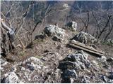 45
45
Discussion about the trip Štore - Srebotnik (via Marija and south approach)
|
| bruny26. 03. 2014 |
Respect to the others, some even higher in the Celje hills, but No.1 is somewhere Srebotnik… Evening/night miniAdventure on the above-described trail, also descent from the side of my hiking trifle. We were three and colleague first time on Srebotnik. Both quite enthusiastic, time was just enough, trail without special features and views beautiful with help of artificial light in the Voglajna and Savinja valleys and ,,that's it,,. On the way back, a quick dip into the Bojanski graben gorge, where ice has done a lot of damage, the gorge is poorly passable and the path was a small adventure among fallen trees and deposits of material in the streambed. Again use of friendly logistics for arrival/departure to the starting point and with lack of time in daylight… evening/night right and optimal choice during the week.
GPS track:Srebotnik, 26.03.2014
|
|
|
|
| seinfeld25. 02. 2020 |
Yesterday we did this trail. These hills around Celje are really phenomenal. Krvavica, Kamnik, Srebotnik,... despite low elevation they have everything or even more than two-thousanders. The trail to Srebotnik could be at least partially difficult, as there are some spots where a slip wouldn't end well. We went up past Marija, down along the ridge where it's already tricky when dry, probably dangerous when wet.
If coming by car, better to park in or in front of the settlement Pečovje, because the path from the railway along asphalt drags on quite a bit. At this time of year, the air in Štore is also quite bad, it has a taste.
The hike was leisurely, in the upper time, distance just under 8.5km.
|
|
|
To post a comment you must log in:
If you do not yet have a username, you must first
register.