Stubenbergsee - Kulm (via Kulmkögerl)
Starting point: Stubenbergsee (387 m)
| Latitude/Longitude: | 47,23594°N 15,79699°E |
| |
Route name: via Kulmkögerl
Walking time: 2 h
Difficulty: easy marked way
Elevation gain: 588 m
Elevation difference along the route: 615 m
Map:
Recommended equipment (summer):
Recommended equipment (winter): ice axe, crampons
Views: 237
 | 1 person like this post |
Access to starting point:
A) We leave the A2 Graz - Vienna / Wien highway at the Gleisdorf exit, then follow signs for Hartberg and Weiz, later only for Hartberg and Ilztal. From the roundabout in Ilztal we head towards Hartberg and Pischelsdorf. We leave the road to Hartberg in Kaibing, where we turn left towards Fürstenfeld and St. Johan b.h., at the next crossroads we go left towards St. Johan b.h. From Sankt Johann bei Herberstein we drive to the nearby Stubenbergsee lake, at the end of which we turn left and park at the larger paid parking lot, where parking is allowed from 6 a.m. to 8 p.m. Parking fee until 8 p.m. is 3 euros (November 2022).
B) From Prekmurje we first drive to the Kuzma border crossing, then towards Jennersdorf, just before the mentioned place we turn onto the expressway towards Vrbna / Feldbach. We leave the expressway soon as signs for the motorway and Riegersburg settlement direct us right. We then drive on the main road to Hatzendorf, where we turn left, upon reaching Riegersburg we go right. We then drive to Ilz, where we go right and immediately left towards Stubenbergsee lake. From the roundabout on the edge of Großhartmannsdorf settlement we take the exit towards Großsteinbach settlement, but we continue on the main road all the way to Stubenbergsee lake, at the end of which we turn left and park at the larger paid parking lot, where parking is allowed from 6 a.m. to 8 p.m. Parking fee until 8 p.m. is 3 euros (November 2022).
Route description:
From the parking lot we walk to the bridge over the river Bistrica / Feistritz, after the bridge we arrive at a smaller crossroads. We continue straight on footpath Kulmweg 31 and then continue left and walk parallel to the nearby road. After a few minutes crossing a strip of bushes the path turns right and ascends more steeply. Higher we reach an asphalt road and follow it to the right for some 10 steps, then behind the fence go left and continue the ascent on a narrow path that leads us between fences. Behind the fence we enter the forest and ascend steeply for a few minutes, when we leave the forest with a nice view of Stubenbergsee lake we walk to another asphalt road, which we follow to the left. The path further leads past Gasthaus Windhaber inn, then from a smaller crossroads sharply right. On the asphalt road we continue to the next hamlet, where we temporarily leave the road and continue along the fence of the nearby plot. When we return to the road we go left, a little further right off it onto a grassy path that ascends the panoramic slope to the nearby bench. At the bench the path turns slightly right, then we ascend to the next hamlet, passing the chapel. We also continue following the rare markings, at a smaller crossroads we take the slightly left road that turns even more to the left. Signs for Kulm further on direct us right onto the path along the fence, above the fence we reach a road which we follow left. We do not stay long on this road either as signs lead us right into the forest through which we ascend moderately. Higher we cross two meadows, when we return to the forest from the junction we continue slightly left. A little more ascent follows, when we reach the indistinct ridge we go right towards the Kulmgipfel peak (left Kulm). One more minute of walking follows and we reach the summit with a cross.
From the summit we return some 10 steps to the last junction, then continue on the marked path that continues along the indistinct ridge. Along the path we are accompanied by Stations of the Cross, and in a few minutes we arrive at the saddle connecting both summits.
On the saddle we also step onto the road, past the tourist facility we reach a crossroads where we continue on the upper right road. A bit further from the asphalt road slightly right onto an initially concreted path that soon turns into a grassy track. The track quickly brings us to a log cabin, behind which we return to the asphalt road that leads past the paragliding take-off site. We bypass the take-off site on the right side, the road then enters the forest and we follow it with moderate ascent to its end at Mariabrunn church.
Behind the church and in front of the private house we go left, the marked path splits into two branches. To Kulm summit we can continue on the left northern path or the right southern path. Both paths bring us to Kulm summit in just over 5 minutes of further walking, from which a nice view opens up.
Starting point - Kulmkögerl 1:20, Kulmkögerl - Mariabrunn 0:33, Mariabrunn - Kulm 0:07.
Description and pictures refer to the condition in November 2022.

Photos:
 1
1 2
2 3
3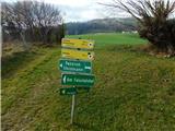 4
4 5
5 6
6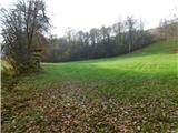 7
7 8
8 9
9 10
10 11
11 12
12 13
13 14
14 15
15 16
16 17
17 18
18 19
19 20
20 21
21 22
22 23
23 24
24 25
25 26
26 27
27 28
28 29
29 30
30 31
31 32
32 33
33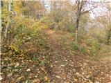 34
34 35
35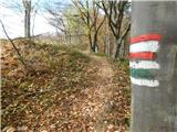 36
36 37
37 38
38 39
39 40
40 41
41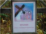 42
42 43
43 44
44 45
45 46
46 47
47 48
48 49
49 50
50 51
51 52
52 53
53 54
54 55
55 56
56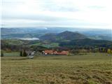 57
57 58
58 59
59 60
60 61
61 62
62 63
63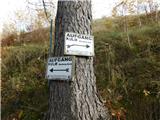 64
64 65
65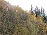 66
66 67
67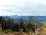 68
68 69
69 70
70 71
71 72
72 73
73 74
74 75
75
Discussion about the trip Stubenbergsee - Kulm (via Kulmkögerl)
To post a comment you must log in:
If you do not yet have a username, you must first
register.