Starting point: Štufna (830 m)
| Latitude/Longitude: | 45,68070°N 15,00820°E |
| |
Walking time: 50 min
Difficulty: easy marked way
Elevation gain: 269 m
Elevation difference along the route: 269 m
Map: Dolenjska 1:50.000
Recommended equipment (summer):
Recommended equipment (winter):
Views: 19.876
 | 2 people like this post |
Access to starting point:
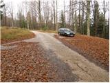
From the highway Ljubljana - Zagreb, take the exit Ivančna Gorica and follow the road ahead in the direction of Črnomelj. Soon after the village Obrh (which is located 1 km before the village Podturn pri Dolenjskih toplicah), the road branches off to the right, which will lead us towards our starting point (direction Rog). Further, we ascend on an asphalt road to the next junction, where signs for Rog, Podstenice, graveyard and Pogorelec and Primož point us to the right on a macadam road (straight Resa, Baza 20). We follow the macadam road, which has a few more junctions ahead, in the direction of Rog. When we notice on the left side of the road a forestry cottage and next to it a sign for Štufna, pay attention to the signposts. A little further, we come to a junction, where we notice signposts for Rog 1h. Here we park on the parking lot by the road.
From Novo Mesto, through Dolenjske Toplice drive to the village Podturn. Here we continue right towards Žužemberk, then soon after the village Podturn we turn sharply left in the direction of Rog. Further, follow the above description.
Access is also possible from Kočevje on forest roads.
Route description:
From the parking lot, we head onto a worse road in the direction of Rog - summit. We follow this road only a short time, as the blazes direct us left onto a cart track, which starts to ascend steeply through the forest. We follow the cart track for approximately 15 minutes, then the blazes direct us left upwards onto a poorly visible footpath, which higher joins the path from Skavtski dom (Žaga Rog). Here we continue right and continue the ascent on a cart track, which barely ascends noticeably. Further on, we will notice beside the usual blazes also blazes in the shape of a bear's paw. After a few minutes of gentle walking, the cart track ascends more steeply and brings us below the summit slope of Veliki Rog. Here the blazes again direct us left onto a footpath, which ascends steeply and after 5 minutes of further walking brings us to the highest peak of the vast forests of Kočevski Rog. From the top, we can also climb to the lookout tower, from which a nice view opens onto the nearby and distant surroundings.
The ascent to the wooden tower is at one's own responsibility.

Photos:
 1
1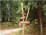 2
2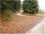 3
3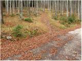 4
4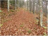 5
5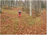 6
6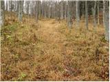 7
7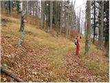 8
8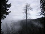 9
9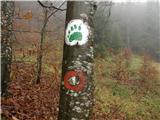 10
10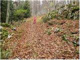 11
11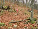 12
12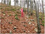 13
13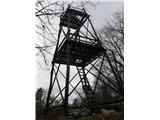 14
14
Discussion about the trip Štufna - Veliki Rog
|
| Lj1. 05. 2010 |
We visited the top of Rog via the path from the Scout home at Žaga. When you climb the viewpoint tower, it's clear why the Kočevje area is called the land of forests. Vast forests on all sides. Now is the best time for an easy hike on this path: fresh green color, ground covered with wild garlic, comfortable trail, suitable also for children (we had a not yet 3-year-old with us, who did the hike on his own feet).
|
|
|
|
| Saten17. 09. 2010 |
Yesterday I ascended Veliki Rog, because it's still in the old "Transverzala". But I didn't find the stamp on it. Maybe someone knows where to get it.
Thanks a lot for any info. Cheers.
|
|
|
|
| odri9. 10. 2011 |
What's the chance of meeting a bear on this trail? I'm afraid of these beasts, so I don't like walking in these Kočevje forests. Though I know it's very nice down there.
|
|
|
|
| Lj9. 10. 2011 |
It's no longer true that only Kočevska is bear territory, you can meet them in the Bohinj area, on Krim or around Ljubljana, on Notranjska and Primorska (Nanos, Vremščica, Snežnik...). Bears usually avoid humans if they detect them. You need really special luck to get between a sow and cubs or stumble unexpectedly on one or snoop around its den...
I don't worry at all anymore about the possibility of meeting a bear on Kočevje trails, I'm more afraid to meet one on the road where it's already jumped in front of my car 5 times. Hiking is so widespread on all marked trails that on weekends you meet hikers on all of them and animals probably know when to avoid crowded paths. Best, Ljubica
|
|
|
|
| Lj9. 10. 2011 |
Well, one more thing I'd add. Once in Rog I met cyclists with a bell on the handlebar, ringing to alert animals to their presence. If hiking alone, you can tie such a bell on your backpack, it can't hurt.
|
|
|
|
| julius21. 04. 2013 |
Today we walked from Baza 20 to the top of Veliki Rog. Still quite a lot of snow. We also saw many bear tracks, human ones almost none.
The stamp is cemented on the right, outer side of the tower.
Sometimes you need to check around the tower, summit etc. to find what you're looking for.
|
|
|
|
| Ivica 19. 07. 2013 |
How long did it take you on foot from Base 20 to Rog. I namely run every day to Jeledol from Dolejne toplice past base 20, but haven't gone to Rog yet, planning it this year .Ivica.
|
|
|
|
| aditaker8. 01. 2015 |
Hello, since I'm not from your parts I'm curious what the path to Veliki Rog is like, is it trodden or are there snow drifts or no major problems? And secondly, I'm also interested where the path runs or where the starting point is so that I go with my girlfriend first to Baza 20 and then to Veliki Rog and how long it would take, to see if it's worth it for us and what the path is like now in these winter conditions, please for advice and we plan to go this Sunday and wonder if there's any mountain hut on the path too?
|
|
|
|
| grega_p4. 01. 2018 |
Really nice, peaceful, panoramic hike.
On the path from the scout home there are currently some fallen spruces, but the detours are somehow logical, now in the snow everything is full of tracks of predecessors.
Today despite slightly cloudy weather beautiful views to all ends of Slovenia - Julian and Kamnik-Savinja Alps, Snežnik, Gorjanci, Pohorje. And of course everything in between.
Since the storm really did its thing down there, one must be careful as certain branches are hanging in "the air". Also when driving by car from the Kočevje side there are many leaning trees. When I decided to go further by car to Dolenjske Toplice, a huge spruce across the road prevented me. Two called and waited for foresters, I preferred to turn around and go back home the same way.
If you are interested in remote areas, forest silence, relaxed hamlets of Kočevje villages, these ends are really the right choice. And of course, don't forget that this is bear habitat.
|
|
|
|
| AndroB17. 10. 2025 10:24:58 |
The path is really pleasant. It is still well marked.
Unfortunately, the tower is no longer there, so no view either. Pity. I hope they rebuild it.
Otherwise, peace and quiet. No living souls anywhere, neither human nor bear.
In the surroundings, many natural and other sights worth seeing.
|
|
|
To post a comment you must log in:
If you do not yet have a username, you must first
register.