Starting point: Sveta Ana (725 m)
| Latitude/Longitude: | 45,73730°N 14,45170°E |
| |
Walking time: 20 min
Difficulty: easy marked way
Elevation gain: 132 m
Elevation difference along the route: 132 m
Map: Snežnik 1:50.000
Recommended equipment (summer):
Recommended equipment (winter):
Views: 15.346
 | 7 people like this post |
Access to starting point:
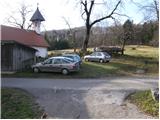
From the Ljubljana - Koper motorway, we take the Unec exit and follow the road ahead in the direction of Cerknica. We then drive through Cerknica, Martinjak and Grahovo to the village Bloška polica, where at the crossroads we continue right in the direction of the village Lož (straight Sodražica, access also possible from that direction). Towards the end of the village Lož, we will notice a road that turns right in the direction of Sveta Ana and Podlož. The somewhat narrower road then brings us to the next crossroads, where we continue left in the direction of the village Sveta Ana (straight Podlož). We follow the road that starts to ascend more steeply ahead to the mentioned village, where we park near the eponymous church.
Route description:
On the opposite side of the church, near the cross we will notice a road which already after a few steps changes into a cart track. We head onto the mentioned road which through a gently sloping meadow in a few minutes brings us to the first chapel, which marks the first Station of the Cross. A wide path then goes into the forest and along numerous chapels starts to ascend more steeply. After approximately 20 minutes of ascent the steepness decreases and the path brings us to the top of Križna gora from which a beautiful view opens up.
Photos:
 1
1 2
2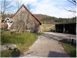 3
3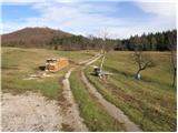 4
4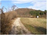 5
5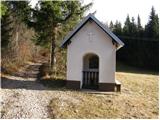 6
6 7
7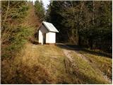 8
8 9
9 10
10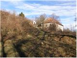 11
11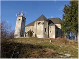 12
12
Discussion about the trip Sveta Ana - Križna gora
|
| Lj4. 12. 2010 |
When I return from the coast via Bloke, this hill with the church catches my eye and only now have I found out it's called Križna gora. The map shows a marked path also from Bločice. Maybe some local can tell where in Bločice to find the start of the trail and if a track has been made perhaps?
|
|
|
|
| katjuša24. 12. 2010 |
I'd say go along the main asphalt road to Križna jama and then up further on gravel or trail.
There's probably quite a lot of snow there and there might be a bear too.
For a track through the village there's very little chance. Maybe ask directly in the inn in the middle of the village.
|
|
|
|
| Lj4. 12. 2010 |
Katjuša2 thanks for the reply. I will really ask around, then decide if perhaps the path from Lož described above would be better. I don't worry much about bears, because in my home area (Kočevska) they walk around gardens...
Best, Ljubica
|
|
|
|
| katjuša24. 12. 2010 |
I prefer to go up the described one from Lož, back past Križna jama or towards Lipsenj.
lp
|
|
|
|
| Lj5. 12. 2010 |
Visited today in a winter fairy tale from Lož to Sv. Ana and on to the top of Križna gora. Back the same way as there was no other track. Nicely combined with ski touring on the Blokah and also tested the slope at Lož  . Suitable for a family outing even in winter. Katjuša2, your areas are beautiful! . Suitable for a family outing even in winter. Katjuša2, your areas are beautiful!
|
|
|
|
| katjuša25. 12. 2010 |
Hm, you know they're not exactly mine, I'm on the other side of Čarovniška Slivnica.
But I like going to the Bloške area, where the cradle of skiing is - as they say.
Glad you managed the winter ascent up to Sv. Ana and higher.
regards
|
|
|
|
| noteko6. 12. 2010 |
From Bločice numerous small paths lead to the top of Križna gora, but they are unmarked, run through overgrown forest and one can quickly get lost if not familiar with these paths. Now in winter time it's best to set off from Bloške Police towards Križna cave, this path is also regularly plowed. Car can be left there. Then we have to wade through snow on the macadam path towards Križna gora. Nice trip also from Lipsenj direction, where a nice 3km long macadam path leads us to the top of Križna gora, at Sveta Ana we join the path from Lož.
|
|
|
|
| Lj6. 12. 2010 |
Noteko, thanks for the info. There will still be something to explore in this area.LpLj
|
|
|
To post a comment you must log in:
If you do not yet have a username, you must first
register.