Sveti Kvirik - Orlovo gnezdo (Veli Badin)
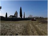
Starting point: Sveti Kvirik (408 m)
| Latitude/Longitude: | 45,46380°N 13,90430°E |
| |
Walking time: 1 h
Difficulty: easy marked way, difficult marked way
Elevation gain: -49 m
Elevation difference along the route: 35 m
Map: Slovenska Istra - Čičarija, Brkini in Kras 1:50.000
Recommended equipment (summer): helmet
Recommended equipment (winter): helmet
Views: 45.827
 | 3 people like this post |
Access to starting point:
From the Ljubljana–Koper motorway, take the Črni Kal exit. From Črni Kal, continue driving on the old road towards the coast, but drive along it only to the next somewhat larger intersection, where turn left in the direction of the Sočerga border crossing. On the mentioned road, drive past the settlements Kubed and Gračišče to Sočerga. Here, at the beginning of the settlement, near the former cooperative home, notice the beginning of a narrow asphalt road, up which you quickly ascend to the chapel of St. Kvirik, which is the starting point for our hike.
Route description:
The described old path is closed in its final section due to nesting of rare bird species. The new path in the final section runs somewhat more to the left and is technically not demanding.
From the chapel of St. Kvirik, continue on the marked path in the direction of the bunker and natural bridge. The path initially follows a gentle, partly grassy cart track, along which we walk in a few minutes to the nearby RTV transmitters.
From the transmitters, the path begins to descend gradually, leading us partly across panoramic slopes, partly along and beside an occasionally precipitous ridge (the path is always kept away from the precipices). After a few minutes, we reach a small junction, where a 50 m long path to the nearby bunker (small natural window) branches off to the right; we continue straight ahead on the path, which, except for a few short ascents, mostly descends gently to moderately. Lower down, we cross a strip of forest, and the path brings us to the edge of the ridge. Here, the path continues to descend slightly, crossing some slightly exposed spots. The path then levels out and brings us to the precipitous viewpoint of Orlovo gnezdo.
From Orlovo gnezdo, continue on the secured alpine path, which first descends to the nearby gully with the aid of a cable, then also with the aid of pegs. During the descent through the gully, some safety devices assist us, after which the path levels out and turns sharply left. A short traverse follows, then the path brings us to the mighty overhangs of Veli Badin. From the overhangs, continue in the same direction, and a little further on notice the signs for the natural bridge, which direct us left. We quickly reach the mentioned bridge, continue under the arch, and then ascend back to Orlovo gnezdo on an unmarked but clearly visible path.

Along the route: Bunker (390m)
Photos:
 1
1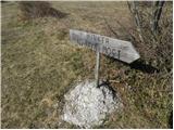 2
2 3
3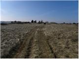 4
4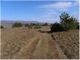 5
5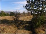 6
6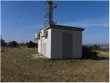 7
7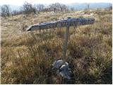 8
8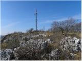 9
9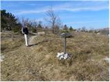 10
10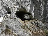 11
11 12
12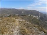 13
13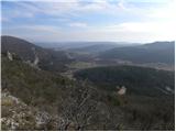 14
14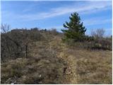 15
15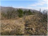 16
16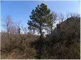 17
17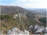 18
18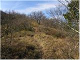 19
19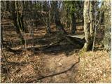 20
20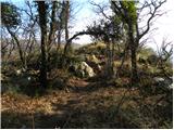 21
21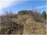 22
22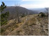 23
23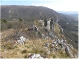 24
24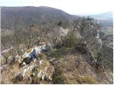 25
25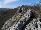 26
26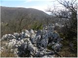 27
27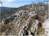 28
28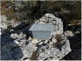 29
29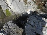 30
30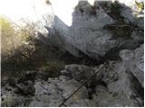 31
31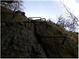 32
32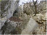 33
33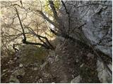 34
34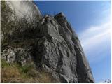 35
35 36
36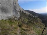 37
37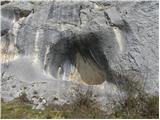 38
38 39
39 40
40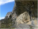 41
41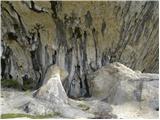 42
42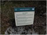 43
43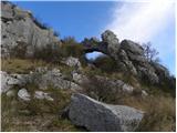 44
44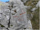 45
45 46
46
Discussion about the trip Sveti Kvirik - Orlovo gnezdo (Veli Badin)
|
| SunnyDay20. 02. 2014 |
The description needs a little correction. The trail is namely led lower down the slope, away from the rock overhang, the wire rope and footrests are also in poor condition, walking under the overhangs is prohibited due to birds.
When descending from the church or transmitter downwards, you come to a small forest, a small valley, there is also the stamp box. And the blue arrows + markers point LEFT towards the valley (if I'm not mistaken, the name of a village is also written on one rock), the trail (slightly less noticeable) also goes straight ahead - that's the old trail, where you walk directly above the overhang, on locally exposed rocks, the trail gets lost a bit in between ... In the small forest/valley at the stamp box, you therefore need to follow the arrow or path left downwards, it leads moderately down through the forest and when you come "to the bottom" out of the forest to the crossroads near the wide macadam, go right and then straight ahead for a couple more minutes (the path then turns slightly right), and you reach the natural bridge and overhangs.
The description describes the old path: "Lower we cross a strip of forest, but the path brings us to the edge of the ridge. Here the path continues slightly descending, crossing some slightly exposed spots. The path then levels out and brings us to the sheer vantage point of Orlovo gnezdo."
And then it mentions the ledge and footrests further, which are probably not safe to use at all. Besides, movement directly above/under the overhangs naturally disturbs the birds (rare, endangered species, some live only here).
|
|
|
|
| gustavs20. 05. 2014 |
Recently we checked out the caves along the repaired path as described by SunnyDay.
I would like to add the following detail: "...and when you come "to the bottom" out of the forest to the intersection near the wide macadam, go right..." - you have to go right on the grassy path that branches off in the clearing - BEFORE the macadam road. If you go right on the macadam you reach the barrier at the SLO-HR border and not the caves.
This turn to the right in the clearing is not marked/signposted so we missed it at first.
Given the changed path and the poor condition of the fixed cables (or what's left of them) it would be correct for the editors to update the path description.
|
|
|
|
| Kigeot26. 01. 2015 |
Beautiful path, wonderful corners of Istria, bunker, natural bridge, caves...
We also got confused in the little forest where the box and logbook are. The signs direct left down the path to the village Dvori. It didn't seem like the right path to us... We continued straight on the less noticeable trail along the overhang. Old markings are still frequent. From the chains, to the old markings, red spray marks have been added, so you know where the path is. The path leads exactly in front of the natural bridge.
|
|
|
|
| vikikrema30. 04. 2016 |
I recommend taking into account the above comments or the sign on the board "Please do not continue the trail!" Today, after a few years, we walked the path described above and wanted to return "from memory" along the overhangs. We were surprised to find that the path is very overgrown, in some sections it is no longer possible to follow it at all. We failed to find the fixed cables, but somehow returned through pathless terrain back to the trail. In the little forest, therefore, follow the markings left into the valley, then turn right just before the road. The junction is not marked!
|
|
|
|
| Badi16. 02. 2017 |
We plan to go on the mentioned path soon. Does anyone know the condition? Is it still completely overgrown or was the path maintained in 2016?
|
|
|
|
| garmont17. 02. 2017 |
The path secured with steel cables and pegs is abandoned due to bird disturbance. The easier path described above is fully passable and sufficiently marked so there should be no orientation problems. 
|
|
|
|
| Lunca29. 05. 2017 |
Yesterday my colleague and I did a loop. At the logbook in the forest we turned left towards Dvori and descended to the valley on the path. Then we missed the mark twice First we went right on the gravel road and reached the above-mentioned barrier on the border. Then we returned to the place where we reached the gravel road, crossed the road and continued in the direction of the sign Učna pot, straight ahead. When we reached the rock with the gunpowder sign and inscription Lačna, we knew this wasn't right either. Then we read the comments written here On the clearing, just before reaching the gravel road, we must watch for a really poorly visible path that doesn't branch off just to the right, but to the right and back, uphill. Soon after that we are at the stone bridge and overhangs. Back we went on the path that goes straight at the little forest with the logbook. So right after the stone bridge we turned left and uphill, and continued on the path that mostly runs along the top of the overhangs, on the edge.
|
|
|
|
| brenco25. 03. 2018 |
The description of this trail needs to be changed. The trail secured with cables and pegs is abandoned and dangerous because the steps are falling out of the wall... 
|
|
|
|
| zlatica29. 03. 2018 |
Yes, that would be more than necessary, as many people read this description and then get confused on the ground. Our Tadej will surely fix it!
|
|
|
|
| Tadej29. 03. 2018 |
It says in the description... "The described old trail has been closed in the last section for some time due to nesting of rare bird species. The new trail in the last section runs a bit further to the left and is not technically demanding."
|
|
|
|
| B229. 03. 2018 |
The sign (pic.43), which we should follow and respect what is written on it, has been in place for several years...
|
|
|
|
| felix1. 04. 2018 |
Now I still don't understand something. A few years ago I was on this trail several times. If now I go down to the bridge on the upper path and then return under the overhangs, where can I exit to the upper path if the secured path is no longer in use? Lp
|
|
|
|
| nacka.1. 04. 2018 |
You crawl, slither and climb through bushes, thorns and rocks upwards until you reach the path. There's nothing to boast about it, but last autumn my husband and I recklessly disregarded the recommendations not to use the lower paths because of birds, we took the overgrown path and ended up in a rather unenviable position. I took this incident as penance for irresponsible behavior. I do not recommend it, as I still have a guilty conscience. Forgive me.
Regards, Nacka
|
|
|
|
| felix1. 04. 2018 |
So, if I understand correctly, the rock shelters can be viewed by going up from the natural bridge, then returning the same way back, but the circular path is no longer possible? I'm really interested in how many birds nest there, since there's a road below with constant rumble, and people walk from above too. This reminds me a bit of wind turbines that only bother birds here with us!
|
|
|
|
| nacka.1. 04. 2018 |
That's right, the circular path is no longer possible. You can go along the upper trail, past the natural bridge and return the same way. Since I'm not an ornithologist, I leave the judgment to the experts.
|
|
|
|
| KSG24. 03. 2022 10:46:47 |
Nice path, especially in spring. Some snapshots from the path this March (past the natural bridge and back the same way: https://bit.ly/3tCunS0
|
|
|
|
| alyas25. 12. 2023 16:41:50 |
Hike – the usual path is easy and beautiful and suitable for a Sunday or holiday trip, the markings on the entire path are satisfactory, also for a ski touring bike trip /blue lines – but for this you need to be a bit more skilled on the bike and have good suspension. The circular panoramic footpath in the second part of the path is of course nicer to do if you descend along the cable - /currently torn and quite rusty/ and along the pegs - /some are missing at the bottom/, from the top edge down to the rock shelters, which you view in the direction of travel to the east. At the end of the rock shelters then through or over the natural window back to the ridge and back to the starting point of the church of St. Kvirik. The circular panoramic footpath in the second part of the path is of course nicer to do if you descend along the cable - /currently torn and quite rusty/ and along the pegs - /some are missing at the bottom/, from the top edge down to the rock shelters, which you view in the direction of travel to the east. At the end of the rock shelters then through or over the natural window back to the ridge and back to the starting point of the church of St. Kvirik.
Of course, that descent (as also described in the introduction), even if it had flawless protections, is not for ordinary hikers in sneakers and although it is short, you need some mountaineering knowledge and experience from via ferrata for it
|
|
|
|
| Majdag22. 10. 2024 17:06:31 |
20.10 - Spodmoli - ears of Istria...
We drove to the little church and continued on the quick path, through the natural bridge. There were already many visitors there. We returned on the longer, more beautiful path. The sumac is mostly still green or the leaves are already falling. Only individual bushes redden and adorn the nature. The overhangs look wonderful, it was nice..
https://jelenkamenmajdag.blogspot.com/2024/10/spodmoli-veli-badin-usesa-istre.html
|
|
|
To post a comment you must log in:
If you do not yet have a username, you must first
register.