Sveti Trije kralji - Mali Šumik waterfall
Starting point: Sveti Trije kralji (1181 m)
| Latitude/Longitude: | 46,43788°N 15,46004°E |
| |
Walking time: 2 h 15 min
Difficulty: difficult marked way
Elevation gain: -291 m
Elevation difference along the route: 125 m
Map: Pohorje 1:50.000
Recommended equipment (summer): helmet
Recommended equipment (winter): helmet, ice axe, crampons
Views: 439
 | 1 person like this post |
Access to starting point:
We drive into the center of Slovenska Bistrica, where at the traffic-light intersection we turn in the direction of the health home and further drive along Partizanska cesta. This is followed by driving through the town, where we continue straight, on the edge of the town at the industrial zone we head onto the road towards Tinje, Sveti Trije kralji and Črno jezero. This is followed by an ascent on a somewhat narrower asphalt road which starts to ascend and first leads past Lovska koča pizzeria Gams, higher we go through the settlement Visole, a few kilometers higher we arrive at Zgornje Tinje, from where we follow the signs for the ski slope Jakec - Trije kralji. We park on the parking lot at the foot of the ski slope, or near the church of the Holy Three Kings.
Route description:
From the starting point, we walk to the church of Sv. Treh Kraljev and continue in the direction of Črno jezero and Urškina pot and quickly arrive at the nearby ski slope, along which we continue briefly, then cross it (during ski slope operation, we cross the ski run and lift higher - above the cableway and ski slope). The path ahead leads past the ARSO weather station, and we continue to follow the blazes; along the connecting ski run, in a few minutes we arrive at another ski run, which we also cross (beside the ski slope upwards Veliki vrh). This is followed by crossing a lift and another ski run, then the path enters the forest, where after a few minutes of further walking we arrive at a cross, beside which stands the educational panel of Urškina pot. The path ahead slowly descends and brings us to a marked junction, where we continue straight in the direction of Šumik waterfall and Ruš (left Črno jezero and Osankarica).
We continue along the gentle path through the forest, which leads us across Peščena ravna; after the indistinct summit Trije studenci, the path gradually begins to descend. Somewhat lower, the forest thins out, the path, which temporarily stops descending, has several junctions where we follow the blazes. After a short gentle ascent, we begin to descend again and lower reach a macadam road that leads from Areh towards Osankarica, which we merely cross and continue the descent to the next road, which we follow to the left (right Ruška koča na Arehu), along which we quickly arrive at the starting point Bajgot na Šumiku, where to the right downwards branches one of the paths towards Ruše (Holcarska pot along the Lobnica valley).
We continue in the mentioned direction, along which there are also signs for Mali and Veliki Šumik waterfalls (straight posestvo Šumik, Koča na Klopnem vrhu...).
The path ahead begins to descend gently along Lobnica, and soon we arrive at a warning that the path ahead is very steep and slippery. Somewhat further, over a footbridge we cross Lobnica, then descend along the right bank of Lobnica, where we gradually move onto steeper slopes. Further on, at the more difficult sections, pegs and steel cables assist us; somewhat lower, with the help of fixed protections we descend over a short wall. Even below the wall, the slope is quite steep and dangerous for slipping, and we descend mainly without protections.
Somewhat lower still we arrive at the spot where the stamp is located, and then along the secured path we descend to the viewpoint for Veliki Šumik waterfall.
From Veliki Šumik we continue along the path that continues descending along Lobnica on locally steep slopes. Somewhat further, with the help of a steel cable we cross the Verna stream, which at high water level turns into several smaller waterfalls. Only somewhat further over a small bridge we cross the Lobnica river. Immediately after the bridge, we notice signs for the waterfall, which is 9 m high.
From the signboard we see the waterfall from above, but if we want to see it from below we continue along the path, which first ascends then descends to a path junction. Here we continue right downwards along the steep path, which quickly brings us to the bed of Lobnica, from which a view opens onto Mali Šumik waterfall.
Sv. Trije kralji - slap Veliki Šumik 2:00, slap Veliki Šumik - slap Mali Šumik 0:15.

Photos:
 1
1 2
2 3
3 4
4 5
5 6
6 7
7 8
8 9
9 10
10 11
11 12
12 13
13 14
14 15
15 16
16 17
17 18
18 19
19 20
20 21
21 22
22 23
23 24
24 25
25 26
26 27
27 28
28 29
29 30
30 31
31 32
32 33
33 34
34 35
35 36
36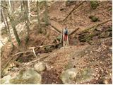 37
37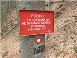 38
38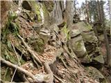 39
39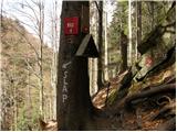 40
40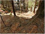 41
41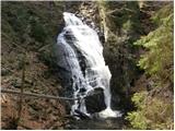 42
42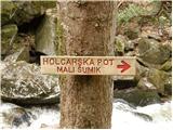 43
43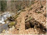 44
44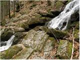 45
45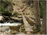 46
46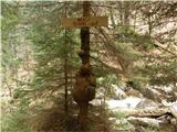 47
47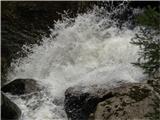 48
48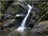 49
49
Discussion about the trip Sveti Trije kralji - Mali Šumik waterfall
To post a comment you must log in:
If you do not yet have a username, you must first
register.