Dolina Kot - Rjavina (ridge crossing Macesnovec-Rjavina)
Starting point: Dolina Kot (950 m)
| Latitude/Longitude: | 46,41570°N 13,89770°E |
| |
Route name: ridge crossing Macesnovec-Rjavina
Walking time: 8 h
Difficulty: very difficult pathless terrain
Elevation gain: 1582 m
Elevation difference along the route: 1750 m
Map: Triglav 1:25.000
Recommended equipment (summer): helmet
Recommended equipment (winter): helmet, ice axe, crampons, lamp
Views: 11.439
 | 4 people like this post |
Access to starting point:
We leave the Gorenjska motorway at the Hrušica exit and follow the road ahead in the direction of Kranjska Gora. Just a little before the village of Dovje, the road which goes to Mojstrana (Vrata, Kot and Krma) branches off to the left from the main road. We follow the road ahead in the direction of the village of Radovna and the valleys of Krma and Kot. The relatively steep road then takes us past the TNP sign, behind which the road soon flattens and brings us to a crossroads, where a macadam road into the Kot valley branches off to the right (straight ahead Radovna and Krma). We then follow this occasionally somewhat rougher road to the parking lot, where we also notice the mountain signposts.
Route description:
From the parking lot we first walk quite some time on the marked path that leads to the mountain hut Staničeva koča. The path is in places slightly exposed, on the most exposed spots secured with some pitons and two steel cables.
When we come to the spring, which we spot on the left side by the path (a short trough is placed there so that we can fill water, next to it on a smaller rock the inscription "drži čistočo"), we need to pay attention: about 50 m ahead the unmarked path branches off to the left upwards from the marked path, namely just before the marked path turns right across the torrent gully.
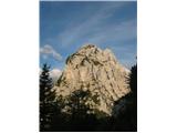
The unmarked but well visible trail climbs quite steeply towards the large scree field, and soon splits into two - right (upper) and left (lower). Both trails join again higher up. The lower (left) one ascends fairly evenly over the scree and among the dwarf pines (often marked with cairns), the upper (right) one first climbs quite steeply over the scree, then leads in a gentle ascent without major pronounced climbs to the place where both paths join again. From there the path continues mostly very steeply along the slope, in the sparse larch forest and dwarf pines it is exposed in quite a few places (slip hazard), but always well traceable. A little below the summit the path crosses the ridge to the other side (until then we were on the slope above Kot, from there on the slope above Krma). Just below the summit the dwarf pines completely replace the previously dominant larches. The summit itself is rocky and covered with grass.
From the summit we descend about 200 length meters, then we start watching for the trail that will take us to the notch between Macesnovec and Dimniki. The terrain is wild and pathless, so rope belaying is recommended! From the notch we climb approximately 30 elevation meters towards the wall, which will take us more or less easily to the summit of Dimniki. I divided the route into three parts, the first wall is approximately 50 m high and takes us to an exceptionally nice ledge covered with dwarf pines (belay station), the second pitch (most difficult) we do along the ridge edge of Dimniki to the next level, which takes us to the last wall. The last wall offers super climbing of upper third grade and takes us about 100 elevation meters below the summit of Dimniki. There are two summits, we descend further towards "žaga", but we avoid the žaga! To the horns and ridge we withdraw to the left (Krma) side. Soon we reach a gully that leads to Luknja peč (easy II-III), there is also a bypass option through the PP window to the north side from there along the ledge to the first gully, up the gully and then past "Skulpture" back to PP and along the "normal route to LP (crumbly I-II). From Luknja peč we descend along the normal route to the "path". In front of us opens the Rjavina ridge, to difficulties we withdraw to the left (Krma) side, but the route goes more or less strictly along the ridge edge, on the ridge there are two descents on rope and one more demanding chimney (IV). The descents are equipped, as is the chimney. In pleasant climbing (II-III) we slowly advance to the last sub-summit of Rjavina (flake!, demanding, friction). Soon we reach the point where the view opens to the cairn and the summit of Rjavina (from here to the summit still less than 100 m). After all-day climbing we finally treat ourselves to a rest, for the wilderness is indescribable. If the roped team is experienced it will manage the ridge (access, climbing, descent) in 10h-15h hours; otherwise it is necessary to carry bivouac gear. Climbing-wise this ridge is one of the harder ones (access to Dimniki IV-).
We descend along the climbing path back to Kot, or along the ridge to Staničev dom.
Equipment: rope, a couple of pitons, some friend and rock nut. Anchor points are there, pitons (a couple) too. The ridge has already been skied in winter.
Safe and especially scenic ascent wishes you Pipi Naveza

Photos:
 1
1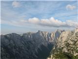 2
2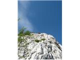 3
3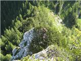 4
4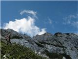 5
5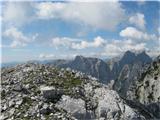 6
6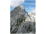 7
7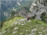 8
8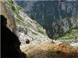 9
9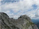 10
10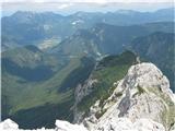 11
11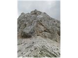 12
12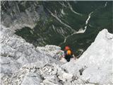 13
13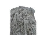 14
14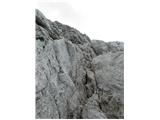 15
15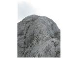 16
16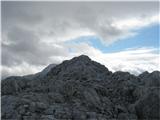 17
17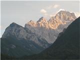 18
18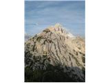 19
19
Discussion about the trip Dolina Kot - Rjavina (ridge crossing Macesnovec-Rjavina)
To post a comment you must log in:
If you do not yet have a username, you must first
register.