Starting point: Dolina Krma (930 m)
| Latitude/Longitude: | 46,38510°N 13,90710°E |
| |
Walking time: 2 h 55 min
Difficulty: difficult marked way
Elevation gain: 1035 m
Elevation difference along the route: 1070 m
Map: TNP 1:50.000
Recommended equipment (summer): helmet
Recommended equipment (winter): helmet, ice axe, crampons
Views: 9.218
 | 1 person like this post |
Access to starting point:
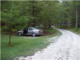
a) We leave the Gorenjska motorway at the Hrušica exit and follow the road further towards Kranjska Gora. Just before the village of Dovje, a road branches left from the main road leading to Mojstrana (Vrata, Kot and Krma). We continue along the road towards the village of Radovna and the Krma and Kot valleys. The relatively steep road then leads us past the TNP sign, after which the road soon levels out and brings us to a junction where a gravel road branches right into the Kot valley. We continue straight on the road which begins to descend. In the middle of the descent a road branches right into the Krma valley (straight on to Radovna). A little further we reach the next junction where we continue right towards Krma. The gravel road then brings us to Kovinarska koča and we follow it further. The occasionally somewhat poorer road then brings us to the parking lot in front of the barrier.
b) We drive to Kranjska Gora, then continue driving towards Jesenice. At Dovje we leave the main road and continue right towards Mojstrana and the Vrata, Kot and Krma valleys, following the signs for Krma at the subsequent junctions. The relatively steep road then leads us past the TNP sign, after which the road soon levels out and brings us to a junction where a gravel road branches right into the Kot valley. We continue straight on the road which begins to descend. In the middle of the descent a road branches right into the Krma valley (straight on to Radovna). A little further we reach the next junction where we continue right towards Krma. The gravel road then brings us to Kovinarska koča and we follow it further. The occasionally somewhat poorer road then brings us to the parking lot in front of the barrier.
Route description:
From the parking lot we go back a few dozen steps, then turn right (left from the access direction to the starting point), towards the east onto the path in the direction of Blejska koča na Lipanci. Initially we ascend only gently, but already after three minutes of walking the path becomes steep, and a few minutes higher we arrive below the cliffs where we notice an inscription that the path we will continue to ascend on was built in 1952.
The path ahead ascends steeply through the forest to a somewhat more demanding passage where we are helped by pegs, less steep steps and a steel cable. The path then leads us among dwarf pines and we follow it further to a mighty torrent gully. To the gully we first descend a little, on the other side we ascend transversely across the steep slope. Crossing the gully is difficult or even impossible after heavy rainfall, but since the slopes are steep the water drains quickly. The path ahead then ascends through the forest, still steeply upwards. The path gets closer and closer to the steep slopes and rock faces. When the forest becomes much sparser the path ascends even more steeply and for a short time becomes so steep that we have to help a little with our hands. This part of the path is especially dangerous for slipping when wet, in dry conditions it does not cause greater danger. The path then brings us below steep rock faces where there is a great danger of falling rocks especially in spring and after rain. We cross below the faces almost horizontally, then the path ascends again. Again we are helped by a steel cable which brings us to grassy slopes. Further we again cross slopes exposed to falling rocks and soon come to a less steep part of the path. We continue ascending on an increasingly scenic path mostly among dwarf pines and sparse forest to a junction where we turn right towards Mrežce and Lipanski vrh (left Lipanska vrata, Brda and Debela peč).
The path ahead in a slight ascent crosses scree below the cliffs of Kredarica peak (1943 m) and after a few minutes brings us onto the ridge where we are again at a junction, specifically at the saddle northeast of Lipanski vrh.
We again continue right (left Kredarica and Lipanska vrata), and continue along the ridge where we notice the sign for Lipanski vrh. The path then mostly ascends among dwarf pines on the increasingly steep summit slope of Lipanski vrh which we reach without major difficulties.
From Lipanski vrh we continue south along the secured ridge towards Mrežce where the path with the help of protections leads us along the ridge down to the notch between Lipanski vrh and Mrežce. From the notch follows a few steps of descent, then with the help of protections we ascend on the increasingly scenic summit slope to the summit of Mrežce.
Starting point - junction below Lipanska vrata 2:25, junction below Lipanska vrata - saddle below Lipanski vrh 0:10, saddle below Lipanski vrh - Lipanski vrh 0:15, Lipanski vrh - Mrežce 0:10.

Along the route: Pod Lipanskimi vrati (1656m), Razpotje pod Lipanskimi vrati (1878m), Sedlo pod Lipanskim vrhom (1910m),
Lipanski vrh (1974m)
Photos:
 1
1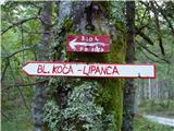 2
2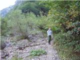 3
3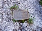 4
4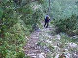 5
5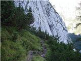 6
6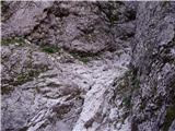 7
7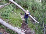 8
8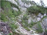 9
9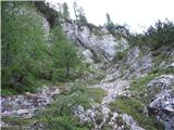 10
10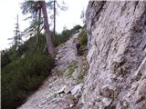 11
11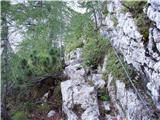 12
12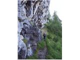 13
13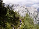 14
14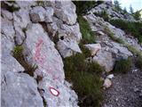 15
15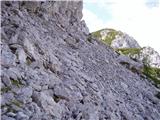 16
16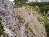 17
17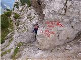 18
18 19
19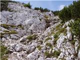 20
20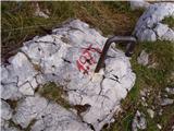 21
21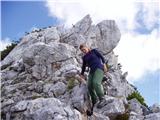 22
22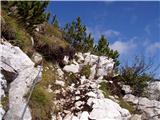 23
23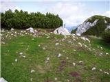 24
24
Discussion about the trip Dolina Krma - Mrežce
|
| LuncaPetra10. 11. 2024 10:58:38 |
Today we walked this path. It's nicely passable and marked, except just before crossing the torrent, instead of turning left we went straight towards the torrent and made the last few meters quite difficult for ourselves.
We descended the same way, and in places where there was mud caution was really needed, because most of it runs through the forest, the roots are very slippery.
|
|
|
To post a comment you must log in:
If you do not yet have a username, you must first
register.