Dolina Krma - Triglav (via Planika and Mali Triglav)
Starting point: Dolina Krma (930 m)
| Latitude/Longitude: | 46,38510°N 13,90710°E |
| |
Route name: via Planika and Mali Triglav
Walking time: 6 h
Difficulty: very difficult marked way
Elevation gain: 1934 m
Elevation difference along the route: 1970 m
Map: Triglav 1:25.000
Recommended equipment (summer): helmet, self belay set
Recommended equipment (winter): helmet, self belay set, ice axe, crampons
Views: 197.676
 | 7 people like this post |
Access to starting point:
a) Leave the Gorenjska motorway at the Hrušica exit and continue following the road towards Kranjska Gora. Just before the village of Dovje, a road branches off to the left from the main road leading to Mojstrana (Vrata, Kot and Krma). Continue following the road towards the village of Radovna and the Krma and Kot valleys. The relatively steep road then takes us past the TNP sign, after which the road soon levels out and brings us to a junction where a gravel road branches off to the right into the Kot valley. Continue straight along the road, which begins to descend. In the middle of the descent, the road to the Krma valley branches off to the right (straight on to Radovna). A little further on we reach the next junction, where we continue right towards Krma. The gravel road then takes us to the Kovinarska koča, which we continue to follow. The occasionally somewhat rougher road then brings us to the parking lot before the barrier.
b) Drive to Kranjska Gora, then continue the drive towards Jesenice. At Dovje leave the main road and continue right towards Mojstrana and the Vrata, Kot and Krma valleys, following the signs for Krma at the following junctions. The relatively steep road then takes us past the TNP sign, after which the road soon levels out and brings us to a junction where a gravel road branches off to the right into the Kot valley. Continue straight along the road, which begins to descend. In the middle of the descent, the road to the Krma valley branches off to the right (straight on to Radovna). A little further on we reach the next junction, where we continue right towards Krma. The gravel road then takes us to the Kovinarska koča, which we continue to follow. The occasionally somewhat rougher road then brings us to the parking lot before the barrier.
Route description:
From the last parking lot in the Krma Valley, called Pri lesi, we continue along the poor road that continues along the valley and soon brings us to a clearing where we bypass the nearby building on the left side. We continue along the gravel path that approaches the torrent and crosses it a little further on. On the other side of the torrent, the path enters the forest and ascends first gently, then quite steeply for some time. Higher up, we leave the forest for the belt of dwarf pines and bushes, and beautiful views open up from the path to the nearby walls of the peaks that descend more gently towards Pokljuka on the other side.
Higher, at an altitude of just over 1400 m, the path levels out temporarily and brings us to the beautiful grassy plain of Vrtača.
After the grassy section, the path begins to ascend again along a path that is often quite slippery in this section, leveling out on the Malo polje plain.
Here the path turns right and forks.
To the left branches the path towards Bohinjska vrata and Vodnikov dom on Velem polju, we continue straight and easily along the foot of Vernar to the spring with a trough.
After the trough the path forks, we continue straight along the marked path (left unmarked shortcut to planina Zgornja Krma). There follows some moderate, higher up somewhat steeper ascent through sparse, partly larch forest. Higher the path turns left and levels out, and from the left the aforementioned shortcut joins.
After the junction of both paths we quickly reach the shepherd's hut on planina Zgornja Krma, called Prgarca.
From here the path continues in a moderate ascent to the west and brings us to the last spring along the path, above the spring the path forks again.
To the left the path continues over Kurica leading to Konjsko sedlo and Dom Planika pod Triglavom, to the right paths lead to Kredarica and Staničev dom pod Triglavom.
We choose the left path that leads under the summit of Kurica and begins to ascend more and more steeply. A few minutes higher we reach a short rocky step, where the path becomes even steeper and especially in wet conditions dangerous for slipping. Above the rocky step the gradient gradually eases, the path leads us under the walls of the nearby peak Oklo, and the path also turns somewhat more to the left. A little further the slope temporarily becomes somewhat steeper, and we continue in a slight traversing ascent to Konjsko sedlo, where there is a junction of several paths.
Continue in the direction of Dom Planika pod Triglavom (left Pokljuka, Vodnikov dom on Velem polju, Uskovnica and Stara Fužina, right Triglavski dom on Kredarici and Dom Valentina Staniča pod Triglavom) and begin a fairly steep ascent to the west. For some time we approach Mokra skala (2266 m), then the path turns right and goes onto an indistinct ridge, where it levels out temporarily. The marked path higher bypasses a small cirque on the right side, then starts turning to the left. Another approximately ten minutes of ascent follows and with beautiful views of the Triglav massif and surrounding mountains we reach Dom Planika pod Triglavom.
We bypass the mountain hut on the right side and continue towards Triglav via Mali Triglav (slightly left Triglav via Triglavska or Bovška škrbina, sharply left Koča na Doliču), where we first descend slightly, then begin to ascend the gradually steeper slope. Soon we reach the rocky section, where we ascend transversely along an exposed ledge, after this section the path temporarily becomes easier. Further on the path turns right and ascends through scree to the climbing section, directed by a larger mark visible from afar.
We continue the ascent along the prominent secured gully, where with the aid of a fixed cable we climb to a nice viewpoint, where the path turns left. A steep ascent follows through rugged terrain, where frequent fixed protections assist us mainly on the more difficult and exposed sections.
Higher we reach the ridge of Mali Triglav, where we join the usually more frequented path from Kredarica.
Continue straight or slightly left (right down Kredarica) and quickly reach the summit of Mali Triglav.
From Mali Triglav there follows some slight descent along an occasionally less exposed ridge, when we start ascending again the ridge narrows and the path becomes precipitous on both sides. Further on there are some quite steep ascents, the path is mainly well protected with cables and individual pegs, and up to the summit on fine days there can be congestion due to passing. Below the summit the path becomes less demanding but still precipitous. Just below the summit a path branches slightly left towards Staničevo zavetišče (emergency bivouac carved into the Triglav massif), we follow the still cautious but last few meters less steep path to the Aljažev stolp, located on the summit of Triglav, the highest mountain of the Julian Alps and Slovenia.
Krma - Zgornja Krma 2:30, Zgornja Krma - Konjsko sedlo 1:00, Konjsko sedlo - Planika 1:00, Planika - Mali Triglav 0:55, Mali Triglav - Triglav 0:35.

Photos:
 1
1 2
2 3
3 4
4 5
5 6
6 7
7 8
8 9
9 10
10 11
11 12
12 13
13 14
14 15
15 16
16 17
17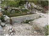 18
18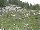 19
19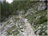 20
20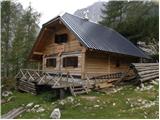 21
21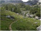 22
22 23
23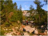 24
24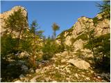 25
25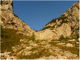 26
26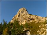 27
27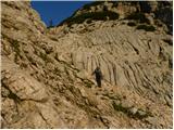 28
28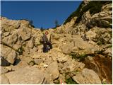 29
29 30
30 31
31 32
32 33
33 34
34 35
35 36
36 37
37 38
38 39
39 40
40 41
41 42
42 43
43 44
44 45
45 46
46 47
47 48
48 49
49 50
50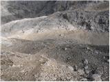 51
51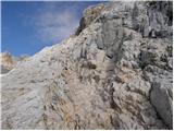 52
52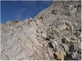 53
53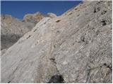 54
54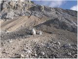 55
55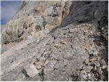 56
56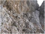 57
57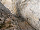 58
58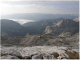 59
59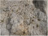 60
60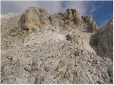 61
61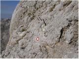 62
62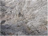 63
63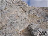 64
64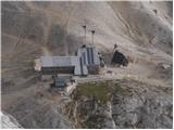 65
65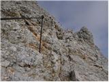 66
66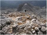 67
67 68
68 69
69 70
70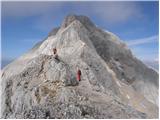 71
71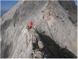 72
72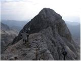 73
73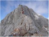 74
74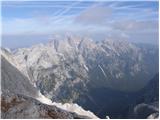 75
75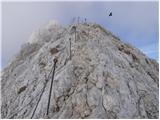 76
76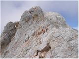 77
77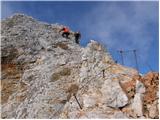 78
78 79
79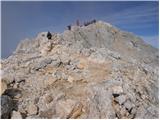 80
80 81
81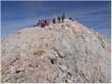 82
82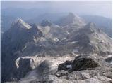 83
83 84
84
Discussion about the trip Dolina Krma - Triglav (via Planika and Mali Triglav)
Show older messages
|
| Gost27. 05. 2006 |
I give a rating of 8, because it seems to me that this is a quite safe path.Damir
|
|
|
|
| Gost17. 10. 2006 |
this path I think suits less experienced and less brave hikers who are climbing Triglav for the first time, maybe I'm wrong. stanko
|
|
|
|
| Gost15. 06. 2007 |
Trip for 100 inexperienced women and some others.
|
|
|
|
| Gost4. 07. 2007 |
I've never been up there but can someone tell me if about 6-year-old kids can go to Triglav too thanks for the answer
|
|
|
|
| Gost6. 07. 2007 |
if you have them roped up with all necessary gear, and you have to overnight then at Kredarica. otherwise no way, because it's too dangerous
|
|
|
|
| Gost6. 07. 2007 |
to Kredarica on this path it would somehow still be ok further on whoever leads in front leads, because otherwise it's way too dangerous, and you need to overnight twice not just once
|
|
|
|
| Gost7. 07. 2007 |
Every trail that you plan to take someone on, it's good to hike it alone first, ESPECIALLY WHEN TAKING SUCH SMALL CHILDREN. That way you'll best assess the difficulty, length, and the like yourself. This trail doesn't seem suitable to me. It's better to take them somewhere else first, introduce hikes and mountains to them differently. I assume you're not some great mountaineer, so I recommend the book: With Children in the Mountains. It will be very useful for everyone.
|
|
|
|
| Gost2. 08. 2007 |
I'm in good shape. I run uphill a lot. Last time I was on Peč via a very difficult secured route. Could I try this "hike" to Triglav alone? Six hours of walking and I'm no longer afraid!
|
|
|
|
| Gost4. 09. 2007 |
Hello!
I plan to go to Triglav for the first time on Saturday. I'm interested in the weather conditions given today's snow, is it too dangerous for the first time? What do you recommend I take with me? Thanks!
|
|
|
|
| Gost4. 09. 2007 |
On Saturday it's Mali Šmaren and the first snow can already fall then. Obligatory trekking poles, warm spare clothing, gaiters and common sense.
|
|
|
|
| Gost5. 09. 2007 |
Snow has already fallen, I hope it'll still be possible to go up, I'm going on Friday.
|
|
|
|
| Gost5. 09. 2007 |
Everyone should decide for themselves where to go. It all depends on fitness, equipment, well-being and many other factors. So asking someone if it's okay to go up? Wherever, everyone decides on their own.
|
|
|
|
| Gost10. 09. 2007 |
This path too is demanding in places namely due to snow patches and melting snow--risk of slipping (Planika hut--Triglav)..
|
|
|
|
| Gost12. 09. 2007 |
On Saturday 15.9.2007 we would go to Triglav via dom Planika and via Mali Triglav. I'm wondering if the snow has melted yet. Thanks
|
|
|
|
| Gost12. 09. 2007 |
If women have already made it up there, then you'll make it too.
|
|
|
|
| pati22. 02. 2008 |
What is the path to Planika like?
|
|
|
|
| Tadej23. 02. 2008 |
The path from Krma to planina Zgornja Krma is well-trodden. From Zgornja Krma onwards (via Kurica) we were wading through deep snow today (old tracks already covered by snow). Even further to Planika we managed somehow, but despite that the mountaineer following us turned back.
|
|
|
|
| bene1. 10. 2008 |
hello in spring I plan to go to Triglav with family. I'm interested which path is the safest. With me would be a 12-year-old child and we are not very experienced with pegs and cables
please for answers
|
|
|
|
| ben1. 10. 2008 |
Better move this "spring" to summer, it will be safer. Otherwise, there's no complete safety, but for Triglav with proper guidance, I think the above-mentioned route is the most suitable.
|
|
|
|
| bene1. 10. 2008 |
And I'm also wondering if there are many fixed cables.
|
|
|
|
| ben1. 10. 2008 |
There are none up to Planika, but the summit head is well secured and I emphasize: NOT for the vertiginous.
Best regards
|
|
|
|
| jersy1. 10. 2008 |
I recommend taking your children, if they have no experience, first on an easier route with some cables... so they get at least a little used to it... I remember going with my father at almost 11 years old to Grintovec via Taška, so I got just a bit of a feel... then you gradually increase the difficulty and soon you're a pro!
|
|
|
|
| jersy1. 10. 2008 |
Or you can take them via Komarča to the hut at the Triglav Lakes or even to the source of the Soča....of course for the first touch of pegs and pitons
|
|
|
|
| jersy1. 10. 2008 |
Or via Mogove from Krvavec over Zvoh to the top of Korena
|
|
|
|
| bene13. 10. 2008 |
now we went to Triglav lakes from Planina Blato back we went where the cables are dunno if there are any or something and it went quite nicely
|
|
|
|
| jersy13. 10. 2008 |
those were pegs yeah for first contact with cables you did quite well
keep it up
Lp!
|
|
|
|
| obscurity31. 08. 2009 |
Hi!
I need advice... in the future my boyfriend and I are planning an ascent to Triglav via this route (precisely because it's supposed to be the easiest). I've already "conquered" quite a few 2000ers and fitness is not a problem. What worries me most are the climbing sections of the ascents  I've encountered them before (e.g. from Škrbina to Vrh nad Škrbino) but I'm still a bit scared because I don't know exactly what to expect on Triglav. I've encountered them before (e.g. from Škrbina to Vrh nad Škrbino) but I'm still a bit scared because I don't know exactly what to expect on Triglav.
Although everyone tells me I'm overcomplicating it since "every Tom, Dick and Harry gets to the top" I'm still in doubt. I'd like to ascend without worries and enjoy it... Am I exaggerating? 
Where should I go (besides e.g. Raduha, Peč...) to gain more "climbing" experience? And what do you think about using a via ferrata set on this route?
Thanks, best regards
|
|
|
|
| turbo31. 08. 2009 |
Obscurity, a nice training tour for Triglav is for example the ascent to Mala Mojstrovka via Hanzova pot. It is appropriately exposed, the fixed protections are such that you can also "train" clipping the via ferrata set, and the descent to Vršič is easy and quick. Since no route to Triglav allows continuous use of the via ferrata set, I suggest visiting Vrbanove špice via Rekarjeva pot. Nice secured route, but like on Triglav, some sections need to be traversed without clipping to the fixed wires. The route itself is incomparably longer than Hanzova to Mojstrovka. For Triglav I suggest ascent to the summit from Dolica, as this route is in my opinion easier than the other two (Kredarica, Planika), and part of it is secured so the via ferrata set comes in handy. As approach to Dolica, consider Zadnjica as starting point. Both Zadnjica-Dolič and Dolič-Triglav summit are less crowded and calmer (for me personally an important factor in choosing a tour and route).
P.S. you're not exaggerating at all. Better a bit of doubt and smartly, than "storming" (like some fool) 
|
|
|
|
| obscurity31. 08. 2009 |
Thanks for the info...
still, looking at the pictures of the suggested routes made me feel a bit queasy  OMG OMG
|
|
|
|
| robter31. 08. 2009 |
A short time ago I went to Triglav for the first time alone from Kredarica. At first I didn't believe we would climb that rock, I was sure there was some path behind it, like say on Grintavec or something similar. Well on the way I thought: what the hell did I need this for, first and last time and never again, the mountain isn't crazy etc. Now that it's all behind me and after reflection I'd go again right away and probably will next year too.
So obscurity, don't hesitate too much. But you must have respect for the mountain (you must be a little scared all the time) to be even more cautious than usual.
Definitely not for those with vertigo.
Best regards
|
|
|
|
| JanaG10. 09. 2009 |
We ascended Triglav on Sunday 06.09.09, properly dressed and equipped. Weather: cold, snow patches, strong wind on ridge, fog on summit so not much view...
|
|
|
|
| štajerc10. 09. 2009 |
This trail is the most suitable for a one-day ascent to Triglav. For an average hiker, it's 4.5-5 hours of moderate walking from Krma to the summit.
|
|
|
|
| Branee23. 07. 2010 |
I've read and looked at all the paths described to Triglav and after consideration I've decided that this one might really be the most suitable for a 1-day trip. Is a via ferrata set really needed because in the pictures there's nothing particularly requiring it?
Branko
|
|
|
|
| velkavrh23. 07. 2010 |
Indeed this is the most pleasant tour for the first ascent to our champion. To Planika you really don't need any safety gear except good shoes. For the ascent to Triglav it's good to have a helmet, mainly because the hiker in front of you can dislodge a stone. Otherwise it's an equally pleasant path from Pokljuka to Vonikova koča and then to Planika. I wish you lots of mountain pleasures!
|
|
|
|
| ljubitelj gora23. 07. 2010 |
@Brane
Absolutely this is one of the easiest paths to Triglav, from Planika onwards the path is very demanding, the safety gear is impeccable, almost the entire path you hold onto the safety cables.
|
|
|
|
| amar nat26. 07. 2010 |
Hi! In autumn we're heading to Triglav for the first time and I'm interested which path is the most suitable? Is ascent and descent possible in one day? Thanks.
|
|
|
|
| Kriška26. 07. 2010 |
I can't believe it ... is this question serious, or ...? After all the detailed descriptions, all the extensive debates - comments, photos???
|
|
|
|
| šerpa26. 07. 2010 |
"amar nat"
Which path is most suitable for you depends on many factors: your psychophysical condition, experience in high mountains.... I myself on Thursday did the tour Krma-Planika-Triglavska škrbina-Triglav-Mali Triglav-Planika-ovinek via Vodnikov dom and back to Krma via Bohinjska vrata. After 12 hours from the start I was back in Krma. If I hadn't enjoyed the sunshine a bit in between and taken lots of photos, I would have been much faster, but I must emphasize that this path involves 2,140 meters of ascent and just as much descent, which requires really good fitness. If you're going up for the first time, I suggest someone who has already been up there and masters mountaineering goes with you, or even better, go for two days. That way the tour will remain in much nicer memory for you, and the weather risk is spread over two days. And move this "autumn" to early autumn, otherwise you might need winter gear. Also browse hribi.net a bit more and read topics about Triglav etc. - there are quite a few with useful advice. Have a nice and safe ascent!
lp
|
|
|
|
| amar nat26. 07. 2010 |
"Kriška", I think that we live in a more or less free country and that we can ask questions that seem important to us, as long as we don't offend others. If I accidentally offended you with this, I apologize and ask you not to get angry, because it harms beauty.
Luckily there are still people who gladly help and advise us who venture on such a path for the first time and for whom every bit of information is very important. Lp.
|
|
|
|
| strelec195426. 07. 2010 |
So that no one scolds me, I'm just interested by which path they take "100 women to Triglav" is it perhaps via "škrbina" thanks for the answer
|
|
|
|
| mukica26. 07. 2010 |
Women go along the usual path from Planika.
Amar nat, as Šerpa already suggested, it's best to do a two-day tour early in autumn. Very nice is from Krma-Kredarica-Triglav-Planika-Konjsko sedlo-Krma or to Vodnik and then back to Krma. It's very nice and when the larches turn slightly colorful, it's already fairy-tale like.
Feel free to ask boldly, some of us will gladly answer because we also get answers when we need them. Everyone once started with hiking or forum participation. LP
|
|
|
|
| amar nat26. 07. 2010 |
"Šerpa" and "mukica", thank you very much for the kindness!! And understanding. Have a nice day!
|
|
|
|
| petruša15. 08. 2010 |
amar nat, you were asking if this trail is possible in one day. We did this trail on 9.8.2010 in one day, plus two children aged 10 and 11 went along. The trail is not demanding if you have enough stamina. We started from Krma at 6 am and returned at 18:35. On the way up we had three 15-minute stops and one longer than half an hour to eat at Planika. On the way down we also ate pancakes at Planika and from Planika to Krma we stopped twice more for a snack. We also took quite a few photos. So yes, this trail can be done without problems in one day if you have enough stamina. Best regards and safe hiking with full enjoyment
|
|
|
|
| Lisa19. 08. 2010 |
Question.....
On Sunday we are heading to Triglav most likely via this path...from Krma valley, via Planika and Mali Triglav. Overnight at Kredarica, and I'm interested how much do you need to "go off the path" to the hut at Kredarica? Is it too far away, is it better to choose another path?
Please reply.
Thanks and good luck to all.
|
|
|
|
| Kriška19. 08. 2010 |
Someone might get offended again, some other forum members might show off again and repeat what's been said a hundred times, but I'll write this anyway.
I don't understand people who go to the mountains but can't be bothered to even look at a map and read the descriptions with comments (and look at photos) that are posted here on hribi.net and which say everything they're asking?
|
|
|
|
| Bojan_A19. 08. 2010 |
Planika and Kredarica are one hour of walking apart. I suggest ascent via Planika and Mali Triglav, descent back towards Kredarica (where you will overnight) and then further towards Konjsko sedlo, where both paths meet.
Otherwise, as Kriška says, you can figure out a lot from the map, and with the help of this forum especially, because everything is pictured and explained in detail.
|
|
|
|
| Lisa19. 08. 2010 |
Krišika.....don't worry about offending, not everyone bites at the first bone like you with the attack and I fully understand such people. Thanks anyway.
Bojan A..... thank you kindly for the reply. definitely the intention was to check the map, but why not seize the opportunity and ask here too. Better more info than less.
Thanks once again for the suggestion.
Nice day.
|
|
|
|
| IgorZlodej19. 08. 2010 |
Bojan don't crap.. Planika and Kredarica are only 15 minutes apart, that's how long I needed when I was a bit younger, and you're a mountain runner!?
Otherwise, for those going from Krma to Triglav I suggest going to Kredarica because it's closer, then climb from Kredarica to Triglav. Why like that? Because from Kredarica to Mali Triglav is harder, descent to Planika easier. From Planika they can still go overnight to Kredarica, if they have the chance to sleep in a bed of course. I think this weekend around Triglav is already fully booked.
|
|
|
|
| JusAvgustin19. 08. 2010 |
I agree, Kredarica is more exposed than Planika, Planika more exposed than down there. Before setting off for Triglav, check bed availability, look at the weather forecast, ask yourselves if you are fit enough for the tour and only then... I wish you many visits to our mountains, and may they above all be safe. And stop arguing on the forum already..., although sometimes we peek on purpose!
LPP
|
|
|
|
| Bojan_A19. 08. 2010 |
@ Igor, sorry I haven't gone on that connecting path between Kredarica and Planika yet, so I obviously completely misjudged how long (time-wise) it should be.
Sorry once again.
I fully agree that it's better up from Kredarica and down to Planika.
|
|
|
|
| Gorazd G19. 08. 2010 |
Eh guys, now you've totally confused Liso for sure
That hour will be just right. Whether up or down ... What do you say Igor?
|
|
|
|
| vrv19. 08. 2010 |
At Dom na Kredarici there is a sign 45 min to Dom Planika.
|
|
|
|
| Bojan_A19. 08. 2010 |
Well, then I didn't estimate so wrongly after all.
|
|
|
|
| skalar5020. 08. 2010 |
Kredarica - Planika 15 minutes walk? Hmm...
indeed, (serious) talk about mountain timings is anyway (often) a donkey shadow story, but I believe it raises blood pressure for someone who takes it all (too) seriously...
such chasing (can) be good for the liveliness of the forum, just read between the lines, so...
|
|
|
|
| vrv20. 08. 2010 |
Indeed, the path (45min) marked with a sign at Kredarica does not go right under/next to Mali Triglav, but makes a small detour. That path is supposedly no longer in use...
|
|
|
|
| Lisa20. 08. 2010 |
Guys, you're cool! Gorazd... thanks for the concern .
I understand everything, so no problem... you can continue to add or subtract minutes Kredarica - Planika ...
Enjoy!
|
|
|
|
| Bojan_A20. 08. 2010 |
Next time when I go training to Kredarica, I won't do an extension to Triglav, but I'll run along this connecting path to Planika to see how "far" it really is.
|
|
|
|
| main22. 03. 2011 |
I would return to Krma via this path. How many hours from the path is Staničev dom and how much would the arrival in Krma be extended time-wise?
|
|
|
|
| heinz22. 03. 2011 |
about 2 hours. Otherwise it depends on how much time you spend at Staničev (which definitely isn't open at the moment)
|
|
|
|
| heinz22. 03. 2011 |
let me correct: so -the arrival in Krma would be extended time-wise.. (From the path just under an hour -via Rž)
|
|
|
|
| main22. 03. 2011 |
You probably mean that the arrival in Krma would be extended by 2 hours?
|
|
|
|
| heinz22. 03. 2011 |
YES.. or for a bit more. In summer conditions.
|
|
|
|
| main22. 03. 2011 |
both at once
|
|
|
|
| heinz22. 03. 2011 |
Otherwise, the variant is also fine: Krma - Planika - Triglav - Kredarica - Staničeva - Kot.
It's feasible if you have two vehicles available - one in Krma, the other in Kot.
It's quite a long but interesting hike that you'll remember..
|
|
|
|
| VanSims18. 07. 2011 |
Heinz's variant is better in the opposite direction. Walked it this Sunday without ascent to Triglav due to fog and rain already at Kredarica (went around to Planika instead).
From Kredarica to Triglav is harder, descent to Planika easier (as Igor said), besides the descent to Kot is somewhat awkward due to moisture in the lower part and some slightly technically demanding spots (especially from Kredarica to Staniča) and scree. More interesting on ascent.
Descent to Krma is technically easy, much less scree. Only a bit awkward is the part from the last junction before Prgarca to Prgarca itself (but not too bad).
Another comment on the debate about the Kredarica-Planika path. I walked it in half an hour, official time is 45 min.
From Kredarica go down towards Krma and Vodnik and at the first junction follow the sign to Planika (from here 30 min). Climb a bit and there a path joins which is probably unusable without crampons due to snow fields that were still there yesterday. Here turn left and after about 5-10 min we meet some wire ropes. After the first we climb over a rock step (easy), some more serve as protection on exposed spots. After the end of the wires we're at Planika in a few minutes.
|
|
|
|
| VanSims18. 07. 2011 |
Warning: at Prgarica an unleashed barking dog lunges at hikers. We chase it away by charging at it and yelling at the top of our lungs. When I did that it scampered briskly behind the house and until the end of the snack I treated myself to there, there was no sign of it.
Heh, and such a "BEWARE OF FIERCE DOG" as written on the fence of the shepherd's hut. 
|
|
|
|
| JanaG19. 07. 2011 |
VanSins, doesn't that yelling apply to chasing away a bear?
|
|
|
|
| VanSims19. 07. 2011 |
For a bear I think it applies that you should be loud when walking in the forest, even before you meet it. So that it avoids you in advance, because meeting a human is unpleasant for it too.
But once you meet it, I don't think it's wise to yell, let alone charge at it. 
That dog was such that it lunged at me, then retreated and lunged again,... With those really fierce ones that really attack us, even that doesn't apply.
|
|
|
|
| valeri12330. 08. 2011 |
Went on this path to Triglav (28.-29.8.2011),
stayed overnight at Planika, had wonderful weather and a beautiful view
|
|
|
|
| wanyola22. 08. 2012 |
I walked this trail 20.8.-21.8.2012. It was fantastic, weather, company and everything else.
Staff at Planika is friendly, but there was really a crowd, people sleeping in all corners.
I recommend reserving beds.
We met a lot of foreigners, so it's not only Slovenes rushing to Triglav.
I definitely recommend the trail.
|
|
|
|
| marko100119. 07. 2013 |
Is it safe for a less experienced family with a 12-year-old child?
If not, please tell us about some safe route to Triglav.
Thank you for the reply.
|
|
|
|
| Daaam19. 07. 2013 |
Maybe it would be good to gain some experience first.. it's nice everywhere not just on Triglav ..basically this variant is among the easier approaches to daddy Triglav, nevertheless Triglav (especially when crowded) is not suitable for the first encounter in life with cables and pegs..
|
|
|
|
| Keko19. 07. 2013 |
For somewhat less experienced hikers, this path is in my opinion the safest. But generally speaking, every path is safe; only the hiker himself can make it dangerous if his skills and preparation are not up to the path's difficulty level.
So from this viewpoint, there is no safe path to Triglav, as no approach to Triglav is easy and anything can happen on any path.
If you are still completely inexperienced, it's better to first choose a lower peak with an easier approach and gradually increase the difficulty.
As mentioned many times, the climbing routes to Raduha or Peč are perfect for such a test.
If these paths pose no trouble, you can proceed to Triglav, but be aware that it is especially physically much harder and somewhat more technically demanding.
|
|
|
|
| marko100121. 07. 2013 |
Thanks for the answers!
|
|
|
|
| pohodnik3810. 08. 2013 |
Some photos and personal impressions from the hiked trail
PHOTOS
|
|
|
|
| grega12. 09. 2013 |
On Saturday I plan to go to Triglav with my son (12 years old) via Krma. Given that the women are already going down, there shouldn't be crowds, or will there? I haven't gone from this side yet. Would someone who knows the path join me? Is prior reservation for the hut needed?
|
|
|
|
| andrejp3. 09. 2013 |
I can't tell you about the crowds, but I suggest you call the hut immediately and ask for available beds. At this time there are still many people in the high mountains. We're going up next weekend and I reserved a week ago at Planika. The path from Krma itself is well marked and even if you go alone I think you won't have problems (map to help)
Enjoy!
|
|
|
|
| BibaS3. 09. 2013 |
grega1, I definitely recommend reservation to you - it costs you nothing. In such very crowded huts everything can be taken quickly...
|
|
|
|
| ljubitelj gora3. 09. 2013 |
When do they go up to Kredarica/Planika and when are they approximately at the top on Saturday or Sunday.
|
|
|
|
| Loni3. 09. 2013 |
Depends on the speed of movement and weather conditions.
On Saturday the women definitely won't have gone back down yet, but will overnight at Planika, regardless of whether they go to the summit Saturday afternoon or Sunday early morning.
|
|
|
|
| Loni3. 09. 2013 |
Definitivno - ok, my typing blunder
|
|
|
|
| mukica3. 09. 2013 |
The women start on Friday 6.9 early in the morning from the barracks at Pokljuka and in recent years if possible they summit the same day, in any case they are already in the valley on Saturday...
|
|
|
|
| robert1234512. 04. 2014 |
Does anyone have a good clear photo where from Triglav the Slovenian coast Piran or Izola is visible? I'll buy the photo (need it for a book)!
mail
robbie12345@mail.com
|
|
|
|
| markohorvat26. 10. 2014 |
I'm interested in the conditions on this trail. Is it possible without winter gear? Thanks.
|
|
|
|
| pohodnik385. 07. 2015 |
On Wednesday, July 1st, I walked this path and looking back analyzing things, it was the best tour to Triglav so far. Perhaps also because there is still no crowd and everything is so calm and peaceful. The path itself without peculiarities and without snow.
PICTURES AND personal impressions from the path
Best regards! Tone
|
|
|
|
| miranm12. 09. 2018 |
Hello,
I'm interested in how long it takes from Krma via Bohinjska vrata to Vodnikov dom (normal walking).
Thanks and safe steps!
|
|
|
|
| simon7912. 09. 2018 |
I'd say 3 and a half hours of normal walking with short breaks.
|
|
|
|
| miranm12. 09. 2018 |
Thanks for the info.
Best, Miran
|
|
|
|
| sirt112. 09. 2018 |
But; where the hell did you find Mali polje in Krma?
You descend to Mali polje further from Vodnikov dom and it's next to (big) Vele polje!
|
|
|
|
| garmont12. 09. 2018 |
It's not in Krma. It's quite above it.
|
|
|
|
| sirt112. 09. 2018 |
But the "junction at Mali polju" as he calls it, could still be in Krma!
|
|
|
|
| garmont12. 09. 2018 |
How can it be in Krma if it's on the alpine pasture?
|
|
|
|
| sirt112. 09. 2018 |
Click on the cow that's at this junction!
|
|
|
|
| djimuzl12. 09. 2018 |
On the Triglav map (PZS, 1993), the area below Zg. Krma is marked as M. Polje (probably "Malo") - exactly there where the path junction to Bohinjska vratca or Konjsko sedlo is - which simon79 points out.
|
|
|
|
| djimuzl12. 09. 2018 |
The map from 1990 mentions only "Polje"..
|
|
|
|
| simon7913. 09. 2018 |
Dr. Henrik Tuma in "Imenoslovje Julijskih Alp" (reprint of the 1929 edition) names this plain Malo Polje, as I stated. The one mentioned by sirt1 and next to Velega Polja, he calls "Malopolje". So written together. LP and safe steps, I'll be exactly on this section in 3 days.
|
|
|
|
| Hribolazec8111. 10. 2018 |
Does anyone know perhaps how this path is, any snow somewhere?
|
|
|
|
| Grenaleva12. 10. 2018 |
Check current conditions: On Triglav - few days ago someone hiked and described the path as BP
|
|
|
|
| Perosu110. 08. 2019 |
Is this path easier than the one via Kredarica?
|
|
|
|
| bo_zl10. 08. 2019 |
Not much easier than the one from Kredarica, but some obstacles that need to be crossed are fewer here. From Mali Triglav you still go along the ridge though. I prefer the path from Planika directly to Triglav - Gorjanska pot much more. And there's less crowds than on the ridge.
|
|
|
|
| snezzzinka4. 08. 2020 |
On 27. 7. we were in Dolina Krma; somewhere from Kovinarskega doma to Bohinjska vrata we lost our sunglasses. We will be very grateful to the finder.
|
|
|
|
| Jusk12. 09. 2020 |
Finally conquered it started at 3am from Krma, already then the parking was packed full, barely found a spot.. good company and easy pace for such a long tour, hours to the summit fly by the path is all OK, towards the shepherd's hut and over Kurica it's damp and slippery. The climbing section is super protected, real enjoyment overall a great day spent in great company
|
|
|
|
| darinka427. 10. 2021 21:02:01 |
Today was a nice sunny day. Almost no one at the top. There's still quite a bit of snow. Winter gear is mandatory.
|
|
|
|
| hribi4324. 06. 2023 06:22:26 |
Is the path from Krma via Planika to Triglav already dry, i.e. passable without winter gear?
Thanks
|
|
|
|
| momonono19. 08. 2023 23:20:00 |
Is the path from Krma to Triglav already open?
|
|
|
|
| docepe220. 08. 2023 09:07:28 |
Can't you look it up anywhere on the net? It's still closed, check promet.si
|
|
|
|
| djimuzl20. 08. 2023 09:43:04 |
The road will be closed until spring 2024.
|
|
|
To post a comment you must log in:
If you do not yet have a username, you must first
register.