Dolina Krma - Triglav (via Planika and Triglavska škrbina)
Starting point: Dolina Krma (930 m)
| Latitude/Longitude: | 46,38510°N 13,90710°E |
| |
Route name: via Planika and Triglavska škrbina
Walking time: 5 h 55 min
Difficulty: very difficult marked way
Elevation gain: 1934 m
Elevation difference along the route: 1950 m
Map: Triglav 1:25.000
Recommended equipment (summer): helmet, self belay set
Recommended equipment (winter): helmet, self belay set, ice axe, crampons
Views: 71.279
 | 4 people like this post |
Access to starting point:
a) Leave the Gorenjska motorway at the Hrušica exit and continue following the road towards Kranjska Gora. Just before the village of Dovje, a road branches off to the left from the main road leading to Mojstrana (Vrata, Kot and Krma). Continue following the road towards the village of Radovna and the Krma and Kot valleys. The fairly steep road then takes us past the TNP sign, after which the road soon levels out and brings us to a junction where a gravel road branches off to the right into the Kot valley. Continue straight on the road, which starts to descend. In the middle of the descent, a road branches off to the right into the Krma valley (straight ahead Radovna). A little further on, we reach the next junction, where we continue right towards Krma. The gravel road then brings us to the Kovinarska koča, but we follow it further. The occasionally somewhat rougher road then brings us to the parking lot before the barrier.
b) Drive to Kranjska Gora, then continue driving towards Jesenice. At Dovje, leave the main road and continue right towards Mojstrana and the Vrata, Kot and Krma valleys, and at the following junctions follow the signs for Krma. The fairly steep road then takes us past the TNP sign, after which the road soon levels out and brings us to a junction where a gravel road branches off to the right into the Kot valley. Continue straight on the road, which starts to descend. In the middle of the descent, a road branches off to the right into the Krma valley (straight ahead Radovna). A little further on, we reach the next junction, where we continue right towards Krma. The gravel road then brings us to the Kovinarska koča, but we follow it further. The occasionally somewhat rougher road then brings us to the parking lot before the barrier.
Route description:
From the last parking lot in the Krma Valley, called Pri lesi, we continue on the rougher road that continues up the valley and soon brings us to a clearing where we bypass the nearby building on the left side. We continue on the gravel path that approaches a torrent and crosses it a little further on. On the other side of the torrent, the path enters the forest and first ascends gently, then quite steeply for a while. Higher up, we leave the forest and enter the belt of dwarf pines and shrubs, from the path we enjoy beautiful views of the nearby rock faces of the peaks, which descend more gently towards Pokljuka on the other side.
Higher up, at an altitude of just over 1400 m, the path levels out temporarily and brings us to the beautiful grassy plain of Vrtača.
After the grassy section, the path starts ascending again on a path that is often quite slippery in this section, leveling out on the Malo polje plain.
Here the path turns right and forks.
To the left, a path branches off towards Bohinjska vrata and Vodnikov dom on Velem polju, but we continue straight and easily continue along the foot of Vernar to a spring with a trough.
After the trough, the path forks again, but we continue straight on the marked path (left unmarked shortcut to planina Zgornja Krma). There follows some moderate ascent, higher up somewhat steeper, through sparse, partly larch forest. Higher up, the path turns left and levels out, and from the left the aforementioned shortcut joins us.
After the junction of both paths, we quickly reach the shepherd's hut on planina Zgornja Krma, called Prgarca.
From here, the path continues with a moderate ascent towards the west and brings us to the last spring along the path; above the spring, the path forks again.
To the left, the path continues over Kurica leading towards Konjsko sedlo and Dom Planika pod Triglavom, to the right paths lead to Kredarica and Staničev dom pod Triglavom.
We take the left path, which leads below the summit of Kurica and begins to ascend ever more steeply. A few minutes higher, we reach a short rocky step where the path becomes even steeper and especially dangerous for slipping when wet. Above the rocky step, the steepness gradually eases, the path leads us below the rock faces of the nearby peak Oklo, and the path also turns somewhat more to the left. A little further on, the slope temporarily becomes somewhat steeper, but we continue in a slight traverse ascent to Konjsko sedlo, where there is a junction of several paths.
We continue in the direction of Dom Planika pod Triglavom (left Pokljuka, Vodnikov dom na Velem polju, Uskovnica and Stara Fužina, right Triglavski dom na Kredarici and Dom Valentina Staniča pod Triglavom) and begin a fairly steep ascent towards the west. For a while we approach Mokra skala (2266 m), then the path turns right and passes onto an indistinct ridge where it levels out temporarily. The marked path higher up bypasses a small cirque on the right side, then begins to turn to the left. There follows about ten more minutes of ascent and with beautiful views of the Triglav massif and surrounding mountains we reach Dom Planika pod Triglavom.
At the hut, we head onto the path towards Triglav via Triglavska škrbina, also called the Gorjanska pot. The path ahead first crosses the high-mountain cirque Triglavski kot almost horizontally, where snow persists for most of the year. On the other side of the cirque, the path ascends through scree to the start of the climbing section. The path ascends steeply with the aid of pegs and fixed cables. The well-protected path is exposed to falling rocks, so a helmet is mandatory! The last meters below Triglavska, or Bovška škrbina are less steep but no less dangerous. Ascending on loose sand requires great caution to avoid slipping. At the škrbina, where the path from Dolič joins us and from Plemenic, we continue right upwards on the steep but well-protected path. After a few minutes, the steepness eases and to the summit only a few minutes of ascent on the summit slope await us.
Krma - Zgornja Krma 2:30, Zgornja Krma - Konjsko sedlo 1:00, Konjsko sedlo - Planika 1:00, Planika - Triglav 1:25.

Photos:
 1
1 2
2 3
3 4
4 5
5 6
6 7
7 8
8 9
9 10
10 11
11 12
12 13
13 14
14 15
15 16
16 17
17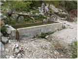 18
18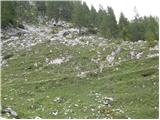 19
19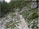 20
20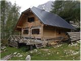 21
21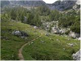 22
22 23
23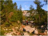 24
24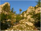 25
25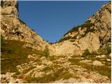 26
26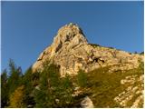 27
27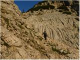 28
28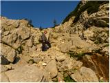 29
29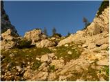 30
30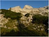 31
31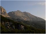 32
32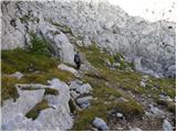 33
33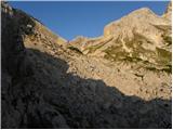 34
34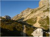 35
35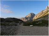 36
36 37
37 38
38 39
39 40
40 41
41 42
42 43
43 44
44 45
45 46
46 47
47 48
48 49
49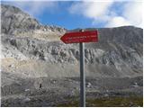 50
50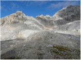 51
51 52
52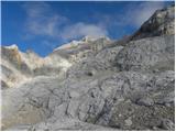 53
53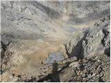 54
54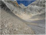 55
55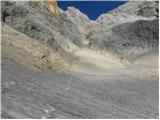 56
56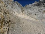 57
57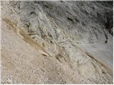 58
58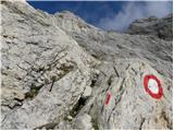 59
59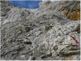 60
60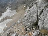 61
61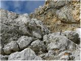 62
62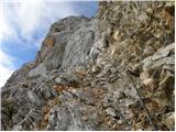 63
63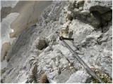 64
64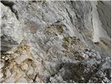 65
65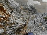 66
66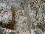 67
67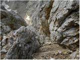 68
68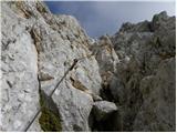 69
69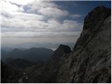 70
70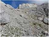 71
71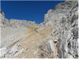 72
72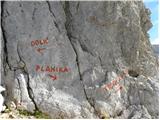 73
73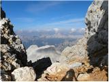 74
74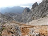 75
75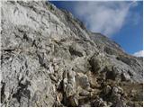 76
76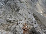 77
77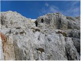 78
78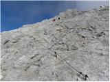 79
79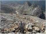 80
80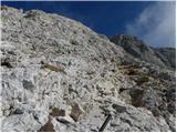 81
81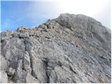 82
82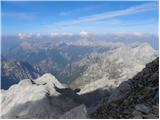 83
83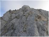 84
84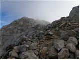 85
85 86
86
Discussion about the trip Dolina Krma - Triglav (via Planika and Triglavska škrbina)
|
| Gost11. 09. 2007 |
Is a complete self-belay set and helmet really necessary??
|
|
|
|
| Gost11. 09. 2007 |
You probably don't need a complete set unless you want to feel safer. A helmet is almost mandatory equipment on high mountain paths!
|
|
|
|
| NEIC00815. 09. 2007 |
To overcome the notch you need quite some "fitness", even onward to Triglav summit is quite strenuous, otherwise safety gear (cables, pegs) is in sufficient quantities.
|
|
|
|
| Gost6. 11. 2007 |
Hello everyone!
I'm interested where snow currently starts on this path, because I'm heading to the summit on Thursday.
Thanks for the reply, Janez
|
|
|
|
| Gost7. 11. 2007 |
First snow, not much of it, starts at about 1400m. Further on, the south-facing slopes are bare up to 2000m (in shady spots sometimes icy) then the thickness of the snow cover increases quickly.
|
|
|
|
| Gost7. 11. 2007 |
Thanks for the reply.
Regards, Janez
|
|
|
|
| slaven3. 07. 2009 |
Hello!
I'm interested in the snow situation from Planika to the summit? Since it rains every day, I think it's possible that it might snow a bit higher up. I would go mid-July. Thanks for the reply!
|
|
|
|
| nevica25. 08. 2009 |
On Sunday in the middle of the night (at 3 o'clock) wake-up. Start from Krma valley at 4:30. Pitch dark like in a den, so we need a veeeeery good flashlight because the stars above shine too dimly. We continue towards Konjsko sedlo to the hut at Planika (4:40h).
After a short break, the real thing begins. The path leads us through Triglavska škrbina all the way to the summit (11:50). Lots of scree on the slabs themselves, not pleasant.
At the top, all the bad from the valley is forgotten. The sun warms us until the descent to Kredarica, where we take a longer break and something modest for the stomach (muesli).
Since we never get enough wandering in the mountains and valleys, we decide together to continue (need a stamp urgently?! ) via Rž peak to Staničeva koča.
It's 16:00, what now!!
Since the youth is full of energy, I abandon the thought of overnight stay, although it would suit me well (41...) and reconcile that we have to go to the valley.
At 20:00 in the valley we rejoice at encounters with chamois, ibex, Apollo, marmot, alpine flowers that accompanied us on the 15-hour path.
Beautiful is this mountain world...
|
|
|
|
| eco28. 12. 2010 |
Greetings to all, a small mountaineering society from Olovo -BiH- intends to climb Triglav in the summer by camping with two tents, overnighting and early in the morning heading to the summit, then overnighting one more night for rest and easier way home. The team is mostly with an average of around 30 years with experience type Maglić Čvrsnica... and we are interested in a path that does not fall into alpinism but is in extreme mountaineering or on the border. We need a recommendation from those who have experience with Triglav. In advance very grateful 
|
|
|
|
| ljubitelj gora2. 10. 2011 |
Went this trail today, my pace, 2:50 hours to the summit, trail is OK, in the Škrbina it's good to have a helmet, ...
|
|
|
|
| _sandra_2. 10. 2011 |
I went yesterday on this trail, quite crumbly in Škrbina yes, so helmet is mandatory here.
|
|
|
|
| ljubitelj gora2. 10. 2011 |
I triggered some loose stones myself but there was no one below, otherwise I'm very careful, if someone is below me, I rather step elsewhere.
|
|
|
|
| NellA44. 07. 2012 |
Hi, I'm wondering if we go on this trail which one is easier for descent, otherwise we'd like to do it so one day up then when descending sleep in a hut
|
|
|
|
| jprim4. 07. 2012 |
Last Saturday we hiked it from Krma - Planika - Škrbina - summit - via Mali Triglav and then back to Planika, that's the best variant ..., but if it's a hot day earlier via Škrbina because it scorches.(tour doable in one day)
LP!
|
|
|
|
| Branee5. 07. 2012 |
come on, it's a walk, on Saturday 30.6 we needed a good 3.5 hours from Krma to the top of Triglav and we were walking in the strongest sun from 10:00 to half past two.. Then we descended to Kredarica and back to Triglav and finally past Kredarica to Kovinarska koča and we were back at the car just after 21..
So it's not exactly Everest and you can do it twice a day up if you have legs and will..
So go boldly
|
|
|
|
| dprapr5. 07. 2012 |
Branee - "from 10:00 to half past two" - that's 4.5 hours!
|
|
|
|
| Branee5. 07. 2012 |
yes, we spent an hour drinking at Planika..
|
|
|
|
| urbancek5. 07. 2012 |
@dprapr: He did write GOOD 3.5 hours
|
|
|
|
| Branee5. 07. 2012 |
but on the way we met runners who were much faster than us (I think they train only on skis, well they were really fast. All they had was that little bottle that looks like a belt bag..
|
|
|
|
| turbo5. 07. 2012 |
That's it!!!
In the strongest sun  (whatever that means, probably not exactly like full moon) then it happens to you. You add up the hours wrong and go to the summit twice because you forgot in between that you had already been up once (whatever that means, probably not exactly like full moon) then it happens to you. You add up the hours wrong and go to the summit twice because you forgot in between that you had already been up once 
|
|
|
|
| Branee5. 07. 2012 |
I didn't time at Planika, because we were changing clothes, taking feet in and out of boots and drank a beer or two, then we continued
But with some fast walking you can be on Triglav from this direction well under 3 hours
|
|
|
|
| Branee5. 07. 2012 |
turbo we went to the summit twice because we thought we had enough energy not because we would have forgotten something
As for the phrase "strongest sun" it's completely normal in our parts, but I can interpret it for you; it means at the time when the sun is strongest
|
|
|
|
| jprim6. 07. 2012 |
I think Branee,  , let that tell you how much boasting there is in your words, we're not all runners, so better say next time that for you it's a walk, so others don't take it as the only truth that getting to Triglav is just a little cat's cough. , let that tell you how much boasting there is in your words, we're not all runners, so better say next time that for you it's a walk, so others don't take it as the only truth that getting to Triglav is just a little cat's cough. 
|
|
|
|
| _sandra_6. 07. 2012 |
@jprim: I agree, under 3 hours to the top of Triglav is a bit unrealistic for average hikers, so waste of words about it..
|
|
|
|
| Daaam6. 07. 2012 |
@.. this Branee is really puffing....even in the brightest sun ...of course it's extremely irresponsible to explain to novices that the path to Triglav is a walk...Bite your tongue a bit...or put the mouse in the corner...
|
|
|
|
| miri6. 07. 2012 |
Some are harmed by the sun too, not just the moon.
|
|
|
|
| ljubitelj gora6. 07. 2012 |
For the restricted path last year I needed 2.50 hours, but I went up midday when it wasn't exactly fresh. Otherwise I normally arrive in 3.30 hours, winter via Kredarica to the top good 7 hours.
|
|
|
|
| Kriška7. 07. 2012 |
Could this bragging about who has the bigger one please be moved to some bar, and leave these pages to those of us who read them for news about the mountains? Thanks!
|
|
|
|
| drago117. 07. 2012 |
Kriška, I completely agree with you. I don't usually comment but I regularly read the news on this forum. Yes, some comments can be very misleading for newcomers. Obviously we go to the mountains each for our own purpose. Some enjoy running up and down and watching the clock, for whatever reason, some even go to Triglav for a "walk", others go to enjoy the mountain beauties and all the other nice things mountains offer, and we don't worry if we took 5:45 hours for the described path as written in the description or less. I wish everyone a nice and safe step!
|
|
|
|
| ljubitelj gora7. 07. 2012 |
I don't have a watch, I only have my mobile in case of emergency and it stays in my backpack the whole trip, on the photo device I also have to look a bit more closely at the time, I only check the departure time from the starting point in the car and then when I get back I calculate how much time I needed. In between I take photos, stop, sit a lot....
|
|
|
|
| Branee7. 07. 2012 |
some of you are really weird, who is boasting here, I just said it informatively without breaking records, because I can't either, because there are people who are much, much faster than me.
But by praising the mountain like that you scare someone, a person thinks twice before even trying..
Anyway, every average hiker should manage this mountain in one day (in summer time, when the day is long.)
|
|
|
|
| čemšeničan7. 07. 2012 |
Kriška, nicely written, I'm just popping into the forum, oh a lawnmower awaits me, that's my training for today, then in the evening to bed, tomorrow early into the mountains. Nice regards.
|
|
|
|
| seinfeld16. 09. 2020 |
Yesterday from Krma through the notch to Triglav. The path from Planika didn't seem particularly crumbly to me at all, it's completely normally passable, even back. We returned towards Kredarica. Despite Tuesday there were huge numbers of us. While we were alone through the notch, columns formed on the ridge and the path was extended by at least half an hour. Altogether 2000 vertical meters, 20 km distance in 9.5 hours.
|
|
|
|
| MinasTirith23. 08. 2024 12:19:59 |
Hello,
I'm interested if the road in Krma valley is open and if you can drive by vehicle to the parking lot beyond Kovinarska koča in Krma?
Lp
|
|
|
|
| DVas23. 08. 2024 13:31:50 |
The news about Krma's opening was published some time ago. It has been open since 1.8.
|
|
|
|
| MinasTirith25. 08. 2024 12:46:19 |
I was yesterday (24.8.2024) on this trail and it's a good choice to avoid crowds and waiting on the ridge. In the section where there is climbing, part is excellently protected with cable and pegs. Personally, I didn't secure myself, as I didn't feel the need, while my niece (age 14) did secure herself. Weather was sunny, no clouds. Wouldn't choose the trail over the notch in wet weather. For the trail (up/down) we needed 10.5 hours, with longer stops at Planika and at the top of Triglav.
|
|
|
To post a comment you must log in:
If you do not yet have a username, you must first
register.