Starting point: Dolina Krma (930 m)
| Latitude/Longitude: | 46,38510°N 13,90710°E |
| |
Walking time: 4 h 5 min
Difficulty: very difficult pathless terrain
Elevation gain: 1295 m
Elevation difference along the route: 1305 m
Map: Triglav 1:25.000
Recommended equipment (summer): helmet
Recommended equipment (winter): helmet, ice axe, crampons
Views: 16.963
 | 3 people like this post |
Access to starting point:
a) Leave the Gorenjska highway at the Hrušica exit and follow the road further in the direction of Kranjska Gora. Just a little before the village of Dovje, a road branches off to the left from the main road, leading to Mojstrana (Vrata, Kot and Krma). Follow the road further in the direction of the village Radovna and the valleys Krma and Kot. The relatively steep road then leads us past the TNP sign, after which the road soon flattens and brings us to a crossroads, where a gravel road branches off to the right into the Kot valley. Continue straight on the road that begins to descend. In the middle of the descent, a road branches off to the right into the Krma valley (straight Radovna). A little further on, we reach the next crossroads, where we continue to the right in the direction of Krma. The gravel road then leads us to the Kovinarska koča, and we follow it further. The occasionally somewhat worse road then leads us to the parking lot in front of the barrier.
b) Drive to Kranjska Gora, then continue driving in the direction of Jesenice. At Dovje, leave the main road and continue to the right in the direction of Mojstrana and the valleys Vrata, Kot and Krma, and at the following crossroads follow the signs for Krma. The relatively steep road then leads us past the TNP sign, after which the road soon flattens and brings us to a crossroads, where a gravel road branches off to the right into the Kot valley. Continue straight on the road that begins to descend. In the middle of the descent, a road branches off to the right into the Krma valley (straight Radovna). A little further on, we reach the next crossroads, where we continue to the right in the direction of Krma. The gravel road then leads us to the Kovinarska koča, and we follow it further. The occasionally somewhat worse road then leads us to the parking lot in front of the barrier.
Route description:
From the last parking lot in the Krma valley, called Pri lesi, we continue on a poorer road that continues along the valley and soon brings us to a clearing, where we bypass the nearby object on the left side. We continue on a gravel path that approaches the torrent and crosses it a little further on. On the other side of the torrent, the path transitions into the forest and initially ascends gently, then quite steeply for some time. Higher up, we transition from the forest into a belt of dwarf pines and shrubs, and from the path, beautiful views open up to the nearby walls of the peaks, which descend more gently towards Pokljuka on the other side.
Higher up, somewhere at an altitude of a little more than 1400 m, the path temporarily flattens and brings us to the beautiful grassy plain Vrtača.
After the grassy part, the path begins to ascend again on a path that is often quite slippery in this part, and it flattens on the plain Malo polje.
Here the path turns to the right and splits.
We continue to the left in the direction of Vodnikov dom on Velo polje (straight Planika and Kredarica) on a path that quickly begins to ascend, initially through a larch forest, then upwards over scree. The path over the scree becomes increasingly steep and is dangerous for slipping in snow, which can persist here until mid-summer. Higher up, we ascend transversely to the left under the walls of Vernar, and due to the narrowness of the last part of the path to Bohinjska vratca, there is also an increased danger of falling rocks. Under the vratca, the path turns slightly to the right and steeply ascends to Bohinjska vratca, from where a beautiful view opens.
From Bohinjska vratca, we continue to the right on an unmarked little path that leads upwards along the grassy slope (straight down Vodnikov dom on Velo polje). The grassy slope becomes increasingly steep and is especially very dangerous for slipping when wet. We then follow the steep little path, which runs slightly to the left of the ridge, all the way to the grassy pre-summit at an altitude of 2183 m.
From the pre-summit, we continue along the ridge and initially descend a few meters steeply along the rocky slope. We continue along the ridge, which becomes quite narrow and exposed. We walk mostly on the left side of the ridge, and the direction is also shown by a few cairns. Then follow a few very short climbing sections (grade I-II) and we are already on the summit of Vernar.
Krma - Malo Polje 2:05, Malo Polje - Bohinjska vratca 1:10, Bohinjska vratca - Vernar 0:50.

Along the route: Vrtača (1430m), Malo polje (1585m), Bohinjska vratca (1979m)
Photos:
 1
1 2
2 3
3 4
4 5
5 6
6 7
7 8
8 9
9 10
10 11
11 12
12 13
13 14
14 15
15 16
16 17
17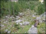 18
18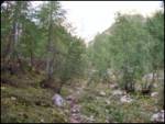 19
19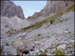 20
20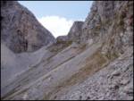 21
21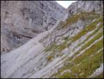 22
22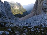 23
23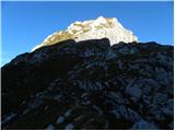 24
24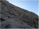 25
25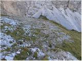 26
26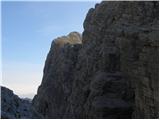 27
27 28
28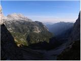 29
29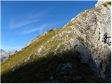 30
30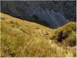 31
31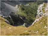 32
32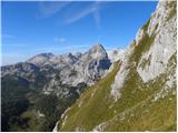 33
33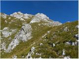 34
34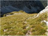 35
35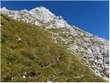 36
36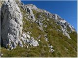 37
37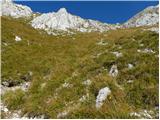 38
38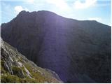 39
39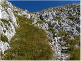 40
40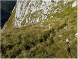 41
41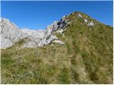 42
42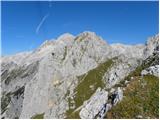 43
43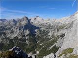 44
44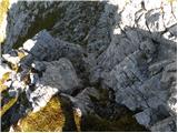 45
45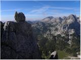 46
46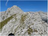 47
47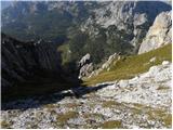 48
48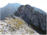 49
49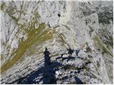 50
50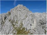 51
51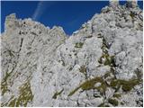 52
52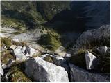 53
53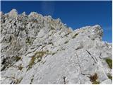 54
54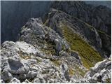 55
55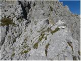 56
56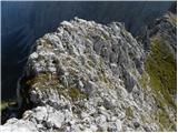 57
57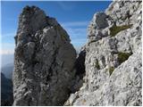 58
58 59
59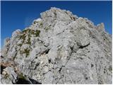 60
60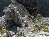 61
61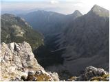 62
62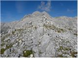 63
63
Discussion about the trip Dolina Krma - Vernar
|
| velkavrh1. 04. 2012 |
Last summer I took this trail. But I only got to the subpeak of Vernar. That descent from the subpeak to the ridge seems really a bit tricky. I would have continued, but strong wind was blowing and it started drizzling lightly, so I quickly descended on slightly damp slippery grass to Vodnikova. The weather calmed and I continued to the mountain pasture and from there to Dolič. On some nice summer day I plan to really conquer Vernar.
|
|
|
|
| Jonny_29. 08. 2012 |
Visited on Friday, 24.8.2012. I think the path doesn't even need to be classified as very demanding. At the end, but really at the end, the last 5-10 minutes you need to hold on a bit with your hand. Before this last part there's a 5-minute ridge - not for the vertiginous. Otherwise, the path is nicely trodden. True, in wet it can be quite unpleasant.
Also "pathless" isn't quite the word for this tour, since up to Bohinjsko sedlo the path is marked, that's about 3/4 of the way, from the saddle you then turn right and soon see the summit, so you can't miss it - just follow the trodden trail.
I from Krma to Malo polje at faster pace took 1.5 hours, from Malo polje to Bohinjsko sedlo 1 hour and 5 minutes (realistically e.g. 45 min), from saddle to summit you can do in half an hour, I had time, so I went slowly and with pleasure - took me just under an hour. Total 3.5 hours, at slow pace.
Vernar is worth visiting if you like peace in the mountains. Didn't meet anyone on the path, on the fairly spacious summit I was completely alone for a good two hours. From the summit, where there's a large cairn, there's a very nice view of Triglav. If you like going barefoot on summits, take flip-flops, as the ground pricks. 
With this tour you'll find out if you like pathless terrain. You'll also see lots of chamois and marmots.
PICTURES
|
|
|
|
| _sandra_29. 08. 2012 |
@Jonny: "With this tour you'll find out if you like pathless terrain.".. doubtful, given that 3/4 of the path is marked, as you mentioned above..? That's not really pathless then 
|
|
|
|
| ljubitelj gora29. 08. 2012 |
Of course it's pathless terrain, just that it should be classified as difficult pathless.
|
|
|
|
| Alfista29. 08. 2012 |
It's marked to the saddle, from there to the peak it's completely pathless.
|
|
|
|
| _sandra_29. 08. 2012 |
I read yes, from the saddle it's pathless...and very demanding..
|
|
|
|
| J.P.31. 07. 2018 |
Path done yesterday. Off-trail from Bohinjske vratce to the top of Vernar. Up to the sign for Vodnikov dom the path is very well marked. Then just a little attention needed (cairns) to the scree where a very well trodden path awaits us again. Off-trail is demanding but not very demanding. As Johnny wrote, a few minutes of ridge walking and two spots to use hands (I-II). No snow on the path after the scree. Good luck.
|
|
|
|
| J.P.31. 07. 2018 |
p.s. - Take a helmet with you anyway. If nothing else, stones fly from Tošca right into the vratca.
|
|
|
|
| bumbi31. 07. 2018 |
Don't underestimate the ridge. It's exposed on both sides and crumbly. Not for everyone. Vernar's neighbor is Tosc.
|
|
|
|
| Sujcic4. 07. 2019 |
Is there any snow on the scree?
|
|
|
|
| tango4. 08. 2022 15:56:24 |
Today my wife and I visited the long-planned Vernar. Of course, with weather like today, it was wonderful. The junction at Malo polje is more for trail followers, as the sign Vodnikov dom on the large boulder has completely faded, but the continuation is then quite straightforward, Tošč even provided shade for a while so it wasn't too hot. The ascent from Bohinjska vrata was easy in dry conditions, along the slope with whole sheets of beautiful gentians, but from the pre-summit onwards it was quite demanding for us. And what's more, besides us there was one other visitor, but on the way back from Malo polje to "Psnakova štala" we were just amazed at what kind of hikers, gear, physical fitness decide to head for Triglav.
|
|
|
To post a comment you must log in:
If you do not yet have a username, you must first
register.