Tinčkova koča - Begunjščica
Starting point: Tinčkova koča (1070 m)
| Latitude/Longitude: | 46,42280°N 14,19910°E |
| |
Walking time: 3 h 15 min
Difficulty: partly demanding marked way
Elevation gain: 990 m
Elevation difference along the route: 990 m
Map: Karavanke - osrednji del 1:50.000
Recommended equipment (summer): helmet
Recommended equipment (winter): helmet, ice axe, crampons
Views: 36.830
 | 3 people like this post |
Access to starting point:
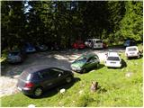
From the highway Ljubljana - Jesenice we go to the exit Lesce and follow the road ahead in the direction of Žirovnica and Jesenice. After a few km of driving, we will get to a crossroads, where the road to Žirovnica and Moste branches off to the right (from the direction of Jesenice left). Only a few meters ahead in the next crossroads, we turn left to Moste (right Žirovnica). Further, we drive past a monument to fallen soldiers, where the road starts ascending a hill below the railway track. On top of the slope, we turn right (at the sign Vila Karin), and we drive towards Završniško jezero lake and Valvasorjev dom. The road then flattens and brings us to a crossroads, where the road towards the mountain hut Valvasorjev dom branches off to the left, and we continue straight on the initially still asphalted road. The road soon becomes macadam, and we follow it to a parking lot near the mountain hut Tinčkova koča. The road in the upper part is often in quite bad condition.
Route description:
From the parking lot at the mountain hut Tinčkova koča we continue on a wide rocky cart track in the direction of the mountain hut Koča pri izviru Završnice. Already after a few steps of walking blazes point us slightly right, on a somewhat steeper footpath which ascends over a panoramic grassy slope, and then it returns to the aforementioned cart track which we follow to the right. Cart track, which relatively steeply ascends through the forest, after a few minutes of further walking brings us to a grazing fence, behind which we come to the marked junction.
We continue right in the direction of the mountain hut Roblekov dom (straight mountain hut Koča pri izviru Završnice) on the path which further at first gently, and then steeper and steeper ascends through the forest. The steepness quickly decreases and the path turns a little to the right, where it crosses relatively steep slopes. After a shorter crossing, the path turns to the left and starts to ascend very steeply along a smaller quite steep valley. Very steep and gravel path (on the descent great risk of slipping) higher for a short time flattens, and then turns to the right, where in zigzags it ascends over again very steep slopes. Higher, the steepness decreases and the path brings us on a side ridge of Begunjščica, on which in a few minutes of further walking, we ascend to the mountain hut Roblekov dom.
From the hut, we continue right in the direction of Veliki vrh on Begunjščica on the path which already after a few steps goes into the forest. The short strip of forest quickly changes into bushes and higher into dwarf pines. After a good 20 minutes of ascent from the mountain hut Roblekov dom we come to the next junction, where we again continue in the direction of Veliki vrh, which is with 2060 m the highest peak of Begunjščica. The path ahead ascends transversely on locally quite steep southern slopes of Begunjščica. The transverse path, which offers nice views on Gorenjska, has in the upper part a larger number of orientation loops. Because of large number of hikers and sheep in the upper part there have formed numerous small paths, which can quickly lead us away from the right path. So as not to get lost, which in fog can quickly happen, we stick to the left (upper) otherwise very poorly marked path. The path, which is also dangerous for slipping when wet, then finally brings us to the panoramic peak.
Starting point - Roblekov dom 1:45, Roblekov dom - Begunjščica 1:30.

Photos:
 1
1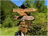 2
2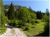 3
3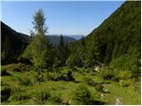 4
4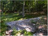 5
5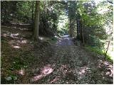 6
6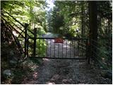 7
7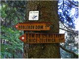 8
8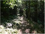 9
9 10
10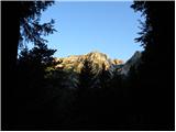 11
11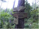 12
12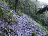 13
13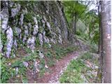 14
14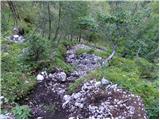 15
15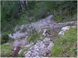 16
16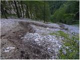 17
17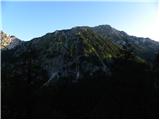 18
18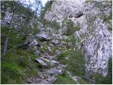 19
19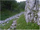 20
20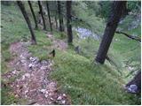 21
21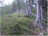 22
22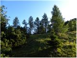 23
23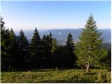 24
24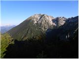 25
25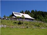 26
26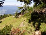 27
27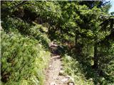 28
28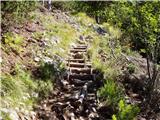 29
29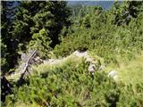 30
30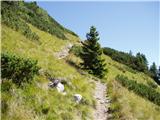 31
31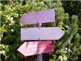 32
32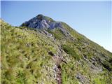 33
33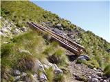 34
34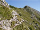 35
35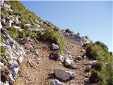 36
36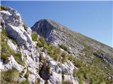 37
37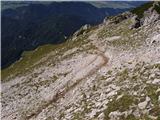 38
38 39
39
Discussion about the trip Tinčkova koča - Begunjščica
|
| gti6. 09. 2010 |
Addition to the path description:
after the last path renovation, the path (even in fog) is orientationally less demanding (fresh markings, reinforced most exposed sections,...). I recommend the circular path: Tinčkova koča - Roblek - Begunjščica - Dom na Zelenici - Tinčkova koča. This last section is the least marked...
|
|
|
|
| Parkeljc8. 02. 2011 |
The path from the second "crossroads" (left Zelenica - right Roblek) through the scree to the ridge is very dangerous in places. At least crampons are needed. I struggled up without them, but they were very useful on the way down.
In the morning at Roblek a couple of visitors. To the summit of Begunjščica we climbed from everywhere  ,,, On the way back the snow was soft, sloppy so it was sinking in, but in places icy, in places completely bare path, so I didn't know whether to put on crampons or not. When I reached Roblek I could hardly find a place to sit, real crowd, occupation ! At least 50 visitors! At first I hesitated to descend to Draga, but when I saw they were still coming, I descended the same way. The path can be quite dangerous, as right below the approach to the ridge there is a vertical wall from which stones constantly fall. Obviously I scared a herd of chamois while descending, which rushed past me down the gully, and behind them quite a few stones rolled into the valley. Helmet is really recommended. ,,, On the way back the snow was soft, sloppy so it was sinking in, but in places icy, in places completely bare path, so I didn't know whether to put on crampons or not. When I reached Roblek I could hardly find a place to sit, real crowd, occupation ! At least 50 visitors! At first I hesitated to descend to Draga, but when I saw they were still coming, I descended the same way. The path can be quite dangerous, as right below the approach to the ridge there is a vertical wall from which stones constantly fall. Obviously I scared a herd of chamois while descending, which rushed past me down the gully, and behind them quite a few stones rolled into the valley. Helmet is really recommended.
|
|
|
|
| JusAvgustin8. 02. 2011 |
obviously Begunjščica hasn't taken many yet so that you walk in winter conditions on the southern path... Even yesterday a colleague was up at Roblek and said that people cheerfully go to V. vrh from Roblek, but return after 20 minutes... Apparently someone really has to get carried to Draga after the J massacre! Such behavior is extremely risky not only irresponsible. Otherwise smart alecks really almost never have anything happen to them, rather to a fully equipped alpinist... But why continue, it won't stick...
|
|
|
|
| heinz8. 02. 2011 |
Exactly! Even more than just - you're right!!
|
|
|
|
| bongo8. 02. 2011 |
what if experts wrote how (and when or from which direction) it is recommended to go up?
as I understood from your words, you have to go up from the northern direction?
I think the information here is incomplete, as the forum is also read by those for whom "ah Šmarna gora, let's go a bit higher now"...my opinion.
|
|
|
|
| JusAvgustin9. 02. 2011 |
Due to the extremely exposed southern slopes and the substrate there (grass on scree), in winter (in winter conditions) an approach from the northern side is recommended, i.e. starting point Ljubelj. From there we have more options. Šentanski plaz is the easiest access among all gullies and couloirs, central gully (slightly more difficult) Smokuški plaz (demanding). Other ravines and gullies are already very demanding. It's not called the mountain of a hundred gullies for nothing, since on the S side Begunjščica (from BV Begunjske Vrtače to Srednji vrh) hides 95 routes, both in gullies and in the wall (mixed). So let me summarize: Winter conditions: approach from the S side, dry conditions: approach from Roblek, via Kalvarija also Šentanski plaz, which in dry conditions is scree... Approaching from the S side in such conditions is a very dangerous undertaking and anyone who knows about it will agree with me. If you slip on the S slope it's GAME OVER. And in winter there are much nicer approaches, as you see the wild wall of Begunjščica and its 100 gullies
if there is any unclarity about this, you can PM me!
|
|
|
|
| bongo9. 02. 2011 |
Thanks for the exhaustive explanation, the question was otherwise completely seriously posed - if someone doubted it.
I asked because someone mentioned a few days ago that from Vrtače they saw a real anthill on Begunjščica, I doubt that the winter approaches you mentioned would "carry" a whole bunch of people. I looked at the mentioned approaches from Zelenica and it seems to me that in winter it's still a feat for more experienced ones and of course with appropriate equipment, I didn't know the conditions from the south side - now it's clearer to me, thanks again
|
|
|
|
| janez.j4. 09. 2011 |
GTI: "I recommend the circular route: Tinčkova koča - Roblek - Begunjščica - Dom na Zelenici - Tinčkova koča."
How much time does that take according to measurements so you know what to take with you,...
Thanks for the reply.
Best
|
|
|
|
| gti5. 09. 2011 |
About 6 hours of moderate hiking with breaks.
|
|
|
|
| Jure874. 08. 2012 |
Today I did the path Tinčkova koča - Zelenica - Begunjščica - Roblekov dom - Tinčkova koča. Nice path, except the annoying scree downhill from Roblekov dom towards Tinčkova koča. It took me less than six hours, but I was walking very fast, and had two long breaks (about 45 minutes each at Begunjščica and Roblekov dom).
|
|
|
|
| Edina15. 11. 2012 |
I discovered this approach today, I really liked it, although fog accompanied me up to 1800 m, when I stepped into heavenly beauty... From the fog only the highest were visible and that 360 degrees around. I descended towards Poljska planina, then on a path less known to me towards Tinčkova koča. This little path is also nice, but recommended only when dry. Today it was wet, plus leaves on the steep slope where in places the path is really only one foot wide. Overall a very nice circular tour.
|
|
|
|
| Edina9. 08. 2013 |
Yesterday again to Roblek via this path through Macesnovec. It's shady and nice, somewhat strenuous in the gully, in wet or on descent it could be dangerous. To the top via the usual path, descent somewhat unusual; via Smokuški plaz. Not for everyone and strictly forbidden in wet conditions. In several places the scree is interrupted and there it's really unpleasant. Probably true that this variant is more suitable for winter conditions. More http://stezeinsledi.blogspot.com/ and happy trails
|
|
|
|
| tenorist14. 09. 2019 |
Hello. What is the road to Tinčkova koča like?
|
|
|
|
| JusAvgustin14. 09. 2019 |
Depends on what car you have and how much damage you can afford.
|
|
|
|
| tenorist14. 09. 2019 |
I have a VW Polo. I'm more interested if there are any big potholes, ditches ... Because towards Tomčeva koča it's really bad 
|
|
|
|
| orchigu5. 07. 2022 20:56:19 |
If someone else has a similar question - I have a Polo and leave it a bit lower on the way to Tinčkova koča, when we start ascending into the forest from the alpine pasture. On the left there's a clearing that's perfect for parking there's almost always some car parked there too. We extend the trail by about 15 min. I really wouldn't test my car (and my nerves) on those last few hairpin turns, the road at the top is really bad. But last weekend down there where the macadam starts I saw a new barrier. It was raised, but there were stickers visa, maestro... for info maybe then those last few turns will be better arranged too, we'll see
|
|
|
|
| Barbara 757. 05. 2024 13:16:44 |
Hello, I'm interested in the condition of the road to Tinčkova koča and if it's possible to park lower down, the car is really low,... I'd go to Svacica, seems like a suitable starting point, thanks for info, B
|
|
|
|
| Toni-k8. 05. 2024 15:10:23 |
I don't know about the road condition,,usually it's good to the pasture,,further on, especially the last slope can be a problem,,,but down in Završnica you have to pay 10 eur to open the barrier.
|
|
|
To post a comment you must log in:
If you do not yet have a username, you must first
register.