Tolminske Ravne - Tolminski Migovec
Starting point: Tolminske Ravne (924 m)
Walking time: 2 h 45 min
Difficulty: easy marked way
Elevation gain: 944 m
Elevation difference along the route: 944 m
Map: Julijske Alpe - zahodni del 1:50.000
Recommended equipment (summer):
Recommended equipment (winter): ice axe, crampons
Views: 30.405
 | 1 person like this post |
Access to starting point:
From Tolmin, a 12 km long drive awaits us to Tolminske Ravne. From the center of Tolmin, we head towards Žabče. In this settlement, we turn right among the houses and above the village continue driving towards Tolminske Ravne. After some time, we descend into the valley, where we cross a bridge and continue uphill towards the Ravne. When we arrive at the village, we turn right onto a smaller parking lot.
The road is completely asphalted, but in some places narrow and with sharp bends.
Route description:
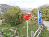
From the parking lot, a path leads us onto the meadow, past the sign for TNP. At the end of the meadow there is a pasture gate, behind it a signpost directs us left uphill on the path to Planina Kal and Migovec. From here continues an easy, poorly marked path, but at junctions well marked with signposts.
We come to a junction for Planina Razor and Planina Kal (also Krn). Again we turn left and continue on more or less flat terrain until we reach a signpost that leads us along a steeper forest path, this time well marked.
When we reach the clearing, we arrive at a junction where we continue right uphill. This junction needs to be well remembered, as it is poorly marked on the way back. After a few minutes, we already glimpse Planina Kal and Migovec above it.
Behind Planina Kal there is a signpost directing to Krn, we follow it, after which it splits a few meters above the huts: left to Krn, right to Migovec.
The path first leads through dwarf pines, then along a rocky path, in places also a small scree field. From the path we have a nice view of the Krn mountain range and the Tolminka valley. Along the rocky path via serpentines we reach the saddle, where we can already see the summit. Here the path leads right upwards to the summit, left downwards to Tolminski Kuk.
We continue right towards the summit, watch out for the limestone slabs that we must cross. The path from the saddle is fairly flat, as the summit is domed. We follow the beaten track to the top.
The summit is marked with a cairn, on it we also find the logbook, stamp and seal.
If we have enough fitness, we can from Planina Kal also visit Grušnica (1570 m), to which leads an easy unmarked path. The elevation difference from Planina Kal is only 80 m.
From the saddle leads right, along the ridge towards the north, a 1.5 km long path to Tolminski Kuk. The path is undemanding, marked with many cairns. The elevation difference from the saddle is approx. 250 m.

Along the route: Planina Kal (1490m)
Photos:
 1
1 2
2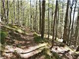 3
3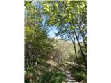 4
4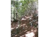 5
5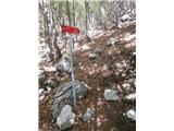 6
6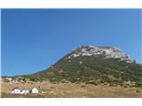 7
7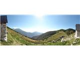 8
8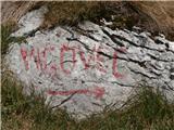 9
9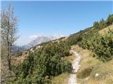 10
10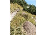 11
11 12
12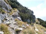 13
13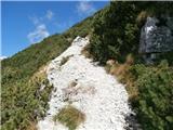 14
14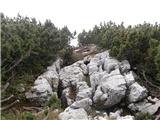 15
15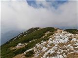 16
16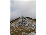 17
17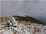 18
18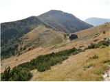 19
19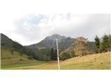 20
20
Discussion about the trip Tolminske Ravne - Tolminski Migovec
|
| d1licen4. 05. 2014 |
Today I tried to ascend to Tolminski Migovec but it didn't go to the top. It gets complicated above Planina Kal, in the middle of the path to the top. There are quite large snowfields where you can't go without crampons and ice axe (icy even at 9 am)
|
|
|
|
| cut4ever4. 07. 2015 |
The path is easy and well marked, it is an easy marked path, not pathless.
The system doesn't allow corrections once you save the entry. I wrote to the website administrators, but in two years they haven't managed to change it yet.
|
|
|
|
| cut4ever4. 07. 2015 |
The path is easy and well marked, it is an easy marked path, not pathless.
The system doesn't allow corrections once you save the entry. I wrote to the website administrators, but in two years they haven't managed to change it yet.
|
|
|
|
| piamhrob26. 06. 2019 |
Easy and nicely marked path, some markers are slightly faded, it is necessary to follow the signs and signposts.
The path marked 'Kravja pot' at the foot (in the forest) is steeper and leads to a junction where we continue right and return to the main path.
|
|
|
|
| darinka430. 01. 2020 |
Were there yesterday after fresh snowfall. Views magnificent as everything was decorated. Especially the scree fields, plentiful all along. No issues with orientation despite invisible path. From junction up to summit quite some windblown snow, sank to waist in places. Path now trodden. Those following have much easier going.
|
|
|
|
| darinka45. 02. 2020 |
How much walking is there from Čadrg village to Kal highland? Is it longer than from Tolminske Ravne?
|
|
|
|
| miri5. 02. 2020 |
Why not from Korit? Beautiful along the ridge.
|
|
|
|
| julika5. 02. 2020 |
From Čadrg it's a good 2 hours' walk.
|
|
|
To post a comment you must log in:
If you do not yet have a username, you must first
register.